
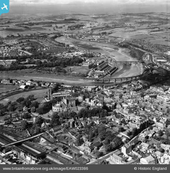
EAW023386 ENGLAND (1949). Lancaster Castle, the River Lune and environs, Lancaster, from the south-west, 1949. This image has been produced from a print.
© Copyright OpenStreetMap contributors and licensed by the OpenStreetMap Foundation. 2025. Cartography is licensed as CC BY-SA.
Nearby Images (15)
EAW023386

EAW005631

EAW005629

EPW042027

EPW026404

EAW003570

EAW037592

EPW029178

EAW005630

EPW042028

EAW005632

EAW005633

EPW002092

EAW023385

EPW002086

Details
| Title | [EAW023386] Lancaster Castle, the River Lune and environs, Lancaster, from the south-west, 1949. This image has been produced from a print. |
| Reference | EAW023386 |
| Date | 25-May-1949 |
| Link | |
| Place name | LANCASTER |
| Parish | |
| District | |
| Country | ENGLAND |
| Easting / Northing | 347368, 461788 |
| Longitude / Latitude | -2.8039682398007, 54.04918032276 |
| National Grid Reference | SD474618 |
Pins
 John Wass |
Saturday 19th of August 2017 02:54:49 PM | |
 sirdouglas |
Sunday 15th of May 2016 12:18:22 PM | |
sirdouglas |
Sunday 15th of May 2016 12:18:00 PM | |
sirdouglas |
Sunday 15th of May 2016 12:17:38 PM | |
Triggy |
Wednesday 29th of April 2015 06:29:42 PM |