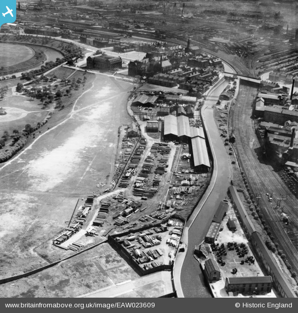
EAW023609 ENGLAND (1949). John H. Ashton Peel Park Sawmills and the Manchester, Bolton and Bury Canal, Salford, 1949
© Copyright OpenStreetMap contributors and licensed by the OpenStreetMap Foundation. 2025. Cartography is licensed as CC BY-SA.
Nearby Images (15)
Details
| Title | [EAW023609] John H. Ashton Peel Park Sawmills and the Manchester, Bolton and Bury Canal, Salford, 1949 |
| Reference | EAW023609 |
| Date | 29-May-1949 |
| Link | |
| Place name | SALFORD |
| Parish | |
| District | |
| Country | ENGLAND |
| Easting / Northing | 381872, 399067 |
| Longitude / Latitude | -2.2732377326179, 53.48775248646 |
| National Grid Reference | SJ819991 |
Pins
 Joseph |
Friday 28th of April 2017 05:27:03 PM | |
 DaveH |
Monday 9th of May 2016 10:36:06 PM | |
 John Wass |
Sunday 3rd of May 2015 09:06:04 PM | |
 boltie |
Sunday 12th of January 2014 03:09:17 PM | |
 boltie |
Sunday 12th of January 2014 03:08:10 PM | |
 boltie |
Sunday 12th of January 2014 03:06:53 PM |


![[EAW023609] John H. Ashton Peel Park Sawmills and the Manchester, Bolton and Bury Canal, Salford, 1949](http://britainfromabove.org.uk/sites/all/libraries/aerofilms-images/public/100x100/EAW/023/EAW023609.jpg)
![[EAW023610] John H. Ashton Peel Park Sawmills, the Manchester, Bolton and Bury Canal and environs, Salford, 1949. This image was marked by Aerofilms Ltd for photo editing.](http://britainfromabove.org.uk/sites/all/libraries/aerofilms-images/public/100x100/EAW/023/EAW023610.jpg)
![[EAW021911] John H. Ashton Ltd Peel Park Sawmills and the Manchester, Bolton and Bury Canal, Salford, 1949. This image was marked by Aerofilms Ltd for photo editing.](http://britainfromabove.org.uk/sites/all/libraries/aerofilms-images/public/100x100/EAW/021/EAW021911.jpg)
![[EAW023604] John H. Ashton Peel Park Sawmills and the Manchester, Bolton and Bury Canal, Salford, 1949. This image was marked by Aerofilms Ltd for photo editing.](http://britainfromabove.org.uk/sites/all/libraries/aerofilms-images/public/100x100/EAW/023/EAW023604.jpg)
![[EAW023606] John H. Ashton Peel Park Sawmills, Peel Park and environs, Salford, 1949. This image was marked by Aerofilms Ltd for photo editing.](http://britainfromabove.org.uk/sites/all/libraries/aerofilms-images/public/100x100/EAW/023/EAW023606.jpg)
![[EAW023607] John H. Ashton Peel Park Sawmills, Peel Park and environs, Salford, 1949. This image was marked by Aerofilms Ltd for photo editing.](http://britainfromabove.org.uk/sites/all/libraries/aerofilms-images/public/100x100/EAW/023/EAW023607.jpg)
![[EAW023605] John H. Ashton Peel Park Sawmills and the Manchester, Bolton and Bury Canal, Salford, 1949. This image was marked by Aerofilms Ltd for photo editing.](http://britainfromabove.org.uk/sites/all/libraries/aerofilms-images/public/100x100/EAW/023/EAW023605.jpg)
![[EAW021916] John H. Ashton Ltd Peel Park Sawmills, the Manchester, Bolton and Bury Canal and Peel Park, Salford, 1949. This image was marked by Aerofilms Ltd for photo editing.](http://britainfromabove.org.uk/sites/all/libraries/aerofilms-images/public/100x100/EAW/021/EAW021916.jpg)
![[EAW021913] John H. Ashton Ltd Peel Park Sawmills and the Manchester, Bolton and Bury Canal, Salford, 1949. This image was marked by Aerofilms Ltd for photo editing.](http://britainfromabove.org.uk/sites/all/libraries/aerofilms-images/public/100x100/EAW/021/EAW021913.jpg)
![[EAW023608] John H. Ashton Peel Park Sawmills and the Manchester, Bolton and Bury Canal, Salford, 1949. This image was marked by Aerofilms Ltd for photo editing.](http://britainfromabove.org.uk/sites/all/libraries/aerofilms-images/public/100x100/EAW/023/EAW023608.jpg)
![[EAW021912] John H. Ashton Ltd Peel Park Sawmills and the Manchester, Bolton and Bury Canal, Salford, 1949. This image was marked by Aerofilms Ltd for photo editing.](http://britainfromabove.org.uk/sites/all/libraries/aerofilms-images/public/100x100/EAW/021/EAW021912.jpg)
![[EAW021914] John H. Ashton Ltd Peel Park Sawmills and the Manchester, Bolton and Bury Canal, Salford, 1949. This image was marked by Aerofilms Ltd for photo editing.](http://britainfromabove.org.uk/sites/all/libraries/aerofilms-images/public/100x100/EAW/021/EAW021914.jpg)
![[EAW023603] John H. Ashton Peel Park Sawmills, the Manchester, Bolton and Bury Canal and environs, Salford, 1949. This image was marked by Aerofilms Ltd for photo editing.](http://britainfromabove.org.uk/sites/all/libraries/aerofilms-images/public/100x100/EAW/023/EAW023603.jpg)
![[EAW021917] John H. Ashton Ltd Peel Park Sawmills, Peel Park and environs, Salford, 1949. This image was marked by Aerofilms Ltd for photo editing.](http://britainfromabove.org.uk/sites/all/libraries/aerofilms-images/public/100x100/EAW/021/EAW021917.jpg)
![[EAW021915] John H. Ashton Ltd Peel Park Sawmills and environs, Salford, from the east, 1949. This image was marked by Aerofilms Ltd for photo editing.](http://britainfromabove.org.uk/sites/all/libraries/aerofilms-images/public/100x100/EAW/021/EAW021915.jpg)