
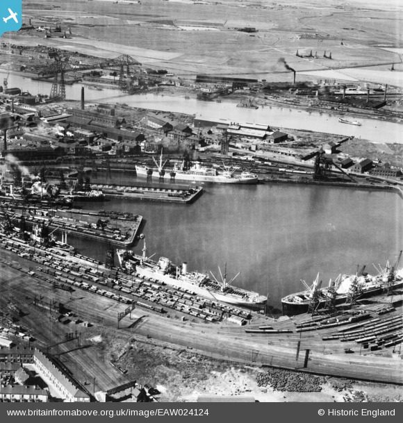
EAW024124 ENGLAND (1949). Middlesbrough Dock and the Transporter Bridge, Middlesbrough, 1949
© Copyright OpenStreetMap contributors and licensed by the OpenStreetMap Foundation. 2025. Cartography is licensed as CC BY-SA.
Nearby Images (3)
EAW024124

EPW010415

EAW024125

Details
| Title | [EAW024124] Middlesbrough Dock and the Transporter Bridge, Middlesbrough, 1949 |
| Reference | EAW024124 |
| Date | 22-June-1949 |
| Link | |
| Place name | MIDDLESBROUGH |
| Parish | |
| District | |
| Country | ENGLAND |
| Easting / Northing | 450228, 520729 |
| Longitude / Latitude | -1.2228309518655, 54.579147846597 |
| National Grid Reference | NZ502207 |
Pins
 ColinMac |
Sunday 30th of July 2023 07:41:22 AM | |
redmist |
Monday 29th of November 2021 10:58:47 PM | |
redmist |
Monday 28th of October 2019 09:38:58 AM | |
redmist |
Monday 28th of October 2019 09:37:34 AM | |
redmist |
Monday 28th of October 2019 09:36:52 AM | |
redmist |
Monday 28th of October 2019 09:30:12 AM | |
redmist |
Monday 28th of October 2019 09:23:45 AM | |
redmist |
Monday 28th of October 2019 09:19:26 AM | |
redmist |
Monday 28th of October 2019 08:59:24 AM | |
redmist |
Monday 28th of October 2019 08:51:01 AM | |
redmist |
Monday 28th of October 2019 08:50:26 AM | |
km |
Monday 16th of June 2014 08:31:40 PM | |
km |
Monday 16th of June 2014 08:30:29 PM | |
km |
Monday 16th of June 2014 08:29:41 PM | |
km |
Monday 16th of June 2014 08:26:50 PM | |
km |
Monday 16th of June 2014 08:24:48 PM | |
km |
Monday 16th of June 2014 08:23:48 PM | |
km |
Monday 16th of June 2014 08:22:40 PM | |
km |
Monday 16th of June 2014 08:21:57 PM |
User Comment Contributions
 Middlesbrough Dock and the Transporter Bridge, Middlesbrough, 1949 |
Ali |
Saturday 15th of February 2014 02:45:22 PM |