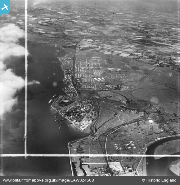
EAW024608 ENGLAND (1949). Shell Haven Oil Refinery, Coryton, from the east, 1949. This image has been produced from a print marked by Aerofilms Ltd for photo editing.
© Copyright OpenStreetMap contributors and licensed by the OpenStreetMap Foundation. 2025. Cartography is licensed as CC BY-SA.
Nearby Images (35)
Details
| Title | [EAW024608] Shell Haven Oil Refinery, Coryton, from the east, 1949. This image has been produced from a print marked by Aerofilms Ltd for photo editing. |
| Reference | EAW024608 |
| Date | 11-July-1949 |
| Link | |
| Place name | CORYTON |
| Parish | |
| District | |
| Country | ENGLAND |
| Easting / Northing | 574875, 182014 |
| Longitude / Latitude | 0.52029693162145, 51.509470846706 |
| National Grid Reference | TQ749820 |
Pins
Be the first to add a comment to this image!


![[EAW024608] Shell Haven Oil Refinery, Coryton, from the east, 1949. This image has been produced from a print marked by Aerofilms Ltd for photo editing.](http://britainfromabove.org.uk/sites/all/libraries/aerofilms-images/public/100x100/EAW/024/EAW024608.jpg)
![[EAW045730] The Coryton Oil Refinery, Coryton, from the south-east, 1952. This image was marked by Aerofilms Ltd for photo editing.](http://britainfromabove.org.uk/sites/all/libraries/aerofilms-images/public/100x100/EAW/045/EAW045730.jpg)
![[EAW034435] Part of the Coryton Oil Refinery under construction, Coryton, from the west, 1951. This image has been produced from a print marked by Aerofilms Ltd for photo editing.](http://britainfromabove.org.uk/sites/all/libraries/aerofilms-images/public/100x100/EAW/034/EAW034435.jpg)
![[EAW034403] Part of the Coryton Oil Refinery under construction, Coryton, 1951. This image has been produced from a print marked by Aerofilms Ltd for photo editing.](http://britainfromabove.org.uk/sites/all/libraries/aerofilms-images/public/100x100/EAW/034/EAW034403.jpg)
![[EAW047421] Coryton Oil Refinery and Holehaven Creek, Coryton, from the south, 1952. This image was marked by Aerofilms Ltd for photo editing.](http://britainfromabove.org.uk/sites/all/libraries/aerofilms-images/public/100x100/EAW/047/EAW047421.jpg)
![[EAW051371] Coryton Oil Refinery and environs, Coryton, from the west, 1953. This image was marked by Aerofilms Ltd for photo editing.](http://britainfromabove.org.uk/sites/all/libraries/aerofilms-images/public/100x100/EAW/051/EAW051371.jpg)
![[EAW034437] Part of the Coryton Oil Refinery under construction, Coryton, 1951. This image has been produced from a print marked by Aerofilms Ltd for photo editing.](http://britainfromabove.org.uk/sites/all/libraries/aerofilms-images/public/100x100/EAW/034/EAW034437.jpg)
![[EAW035783] Part of the Coryton Oil Refinery alongside Holehaven Creek, Coryton, from the south-west, 1951. This image has been produced from a print marked by Aerofilms Ltd for photo editing.](http://britainfromabove.org.uk/sites/all/libraries/aerofilms-images/public/100x100/EAW/035/EAW035783.jpg)
![[EAW043887] The Coryton Oil Refinery, Shell Haven, 1952. This image was marked by Aerofilms Ltd for photo editing.](http://britainfromabove.org.uk/sites/all/libraries/aerofilms-images/public/100x100/EAW/043/EAW043887.jpg)
![[EPW032109] Shell Haven Oil Refinery and environs, Corringham, from the east, 1930](http://britainfromabove.org.uk/sites/all/libraries/aerofilms-images/public/100x100/EPW/032/EPW032109.jpg)
![[EAW048086] Coryton Oil Refinery, Coryton, 1952. This image was marked by Aerofilms Ltd for photo editing.](http://britainfromabove.org.uk/sites/all/libraries/aerofilms-images/public/100x100/EAW/048/EAW048086.jpg)
![[EAW035772] The Coryton Oil Refinery, Coryton, from the west, 1951. This image has been produced from a print marked by Aerofilms Ltd for photo editing.](http://britainfromabove.org.uk/sites/all/libraries/aerofilms-images/public/100x100/EAW/035/EAW035772.jpg)
![[EAW048095] Coryton Oil Refinery, Coryton, from the west, 1952. This image was marked by Aerofilms Ltd for photo editing.](http://britainfromabove.org.uk/sites/all/libraries/aerofilms-images/public/100x100/EAW/048/EAW048095.jpg)
![[EAW048302] Flooding at the Coryton Oil Refinery, Coryton, from the south-east, 1953](http://britainfromabove.org.uk/sites/all/libraries/aerofilms-images/public/100x100/EAW/048/EAW048302.jpg)
![[EAW039884] The Coryton Oil Refinery, Coryton, 1951](http://britainfromabove.org.uk/sites/all/libraries/aerofilms-images/public/100x100/EAW/039/EAW039884.jpg)
![[EAW048587] Upper Horse and the Coryton Oil Refinery under construction, Coryton, 1953. This image was marked by Aerofilms Ltd for photo editing.](http://britainfromabove.org.uk/sites/all/libraries/aerofilms-images/public/100x100/EAW/048/EAW048587.jpg)
![[EAW045734] The Coryton Oil Refinery and Lower Horse, Coryton, 1952. This image was marked by Aerofilms Ltd for photo editing.](http://britainfromabove.org.uk/sites/all/libraries/aerofilms-images/public/100x100/EAW/045/EAW045734.jpg)
![[EAW034436] Part of the Coryton Oil Refinery under construction, Coryton, 1951. This image has been produced from a print marked by Aerofilms Ltd for photo editing.](http://britainfromabove.org.uk/sites/all/libraries/aerofilms-images/public/100x100/EAW/034/EAW034436.jpg)
![[EAW048089] Coryton Oil Refinery, Coryton, from the west, 1952. This image was marked by Aerofilms Ltd for photo editing.](http://britainfromabove.org.uk/sites/all/libraries/aerofilms-images/public/100x100/EAW/048/EAW048089.jpg)
![[EAW043886] The Coryton Oil Refinery, Shell Haven, 1952. This image was marked by Aerofilms Ltd for photo editing.](http://britainfromabove.org.uk/sites/all/libraries/aerofilms-images/public/100x100/EAW/043/EAW043886.jpg)
![[EAW035778] Part of the Coryton Oil Refinery, Coryton, 1951. This image has been produced from a print marked by Aerofilms Ltd for photo editing.](http://britainfromabove.org.uk/sites/all/libraries/aerofilms-images/public/100x100/EAW/035/EAW035778.jpg)
![[EAW047430] Coryton Oil Refinery and environs, Coryton, from the south-west, 1952. This image was marked by Aerofilms Ltd for photo editing.](http://britainfromabove.org.uk/sites/all/libraries/aerofilms-images/public/100x100/EAW/047/EAW047430.jpg)
![[EAW039881] The Coryton Oil Refinery, Coryton, 1951. This image has been produced from a damaged negative.](http://britainfromabove.org.uk/sites/all/libraries/aerofilms-images/public/100x100/EAW/039/EAW039881.jpg)
![[EAW048367] Flooding at the Coryton Oil Refinery, Coryton, from the west, 1953. This image was marked by Aerofilms Ltd for photo editing.](http://britainfromabove.org.uk/sites/all/libraries/aerofilms-images/public/100x100/EAW/048/EAW048367.jpg)
![[EAW047427] Coryton Oil Refinery, Holehaven Creek and environs, Coryton, from the west, 1952. This image was marked by Aerofilms Ltd for photo editing.](http://britainfromabove.org.uk/sites/all/libraries/aerofilms-images/public/100x100/EAW/047/EAW047427.jpg)
![[EAW039894] The Coryton Oil Refinery and Canvey Island, Coryton, from the south-west, 1951](http://britainfromabove.org.uk/sites/all/libraries/aerofilms-images/public/100x100/EAW/039/EAW039894.jpg)
![[EAW034404] Part of the Coryton Oil Refinery under construction, Coryton, 1951. This image has been produced from a print marked by Aerofilms Ltd for photo editing.](http://britainfromabove.org.uk/sites/all/libraries/aerofilms-images/public/100x100/EAW/034/EAW034404.jpg)
![[EAW042274] The Coryton Oil Refinery, Coryton, 1952. This image was marked by Aerofilms Ltd for photo editing.](http://britainfromabove.org.uk/sites/all/libraries/aerofilms-images/public/100x100/EAW/042/EAW042274.jpg)
![[EAW034440] Part of the Coryton Oil Refinery under construction, Coryton, 1951. This image has been produced from a print marked by Aerofilms Ltd for photo editing.](http://britainfromabove.org.uk/sites/all/libraries/aerofilms-images/public/100x100/EAW/034/EAW034440.jpg)
![[EAW048102] Part of the Coryton Oil Refinery under construction, Coryton, 1952. This image was marked by Aerofilms Ltd for photo editing.](http://britainfromabove.org.uk/sites/all/libraries/aerofilms-images/public/100x100/EAW/048/EAW048102.jpg)
![[EAW034438] Part of the Coryton Oil Refinery under construction, Coryton, 1951. This image has been produced from a print marked by Aerofilms Ltd for photo editing.](http://britainfromabove.org.uk/sites/all/libraries/aerofilms-images/public/100x100/EAW/034/EAW034438.jpg)
![[EAW035779] Part of the Coryton Oil Refinery alongside Holehaven Creek, Coryton, from the south-west, 1951. This image has been produced from a print.](http://britainfromabove.org.uk/sites/all/libraries/aerofilms-images/public/100x100/EAW/035/EAW035779.jpg)
![[EAW039886] The Coryton Oil Refinery, Coryton, 1951](http://britainfromabove.org.uk/sites/all/libraries/aerofilms-images/public/100x100/EAW/039/EAW039886.jpg)
![[EPW032110] Shell Haven Oil Refinery and environs, Corringham, from the east, 1930](http://britainfromabove.org.uk/sites/all/libraries/aerofilms-images/public/100x100/EPW/032/EPW032110.jpg)
![[EAW034407] Part of the Coryton Oil Refinery under construction, Coryton, 1951. This image has been produced from a print marked by Aerofilms Ltd for photo editing.](http://britainfromabove.org.uk/sites/all/libraries/aerofilms-images/public/100x100/EAW/034/EAW034407.jpg)