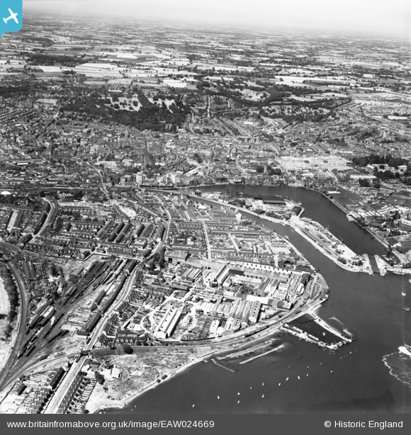
EAW024669 ENGLAND (1949). Stoke, Wet Dock and the town, Ipswich, from the south, 1949
© Copyright OpenStreetMap contributors and licensed by the OpenStreetMap Foundation. 2025. Cartography is licensed as CC BY-SA.
Nearby Images (24)
Details
| Title | [EAW024669] Stoke, Wet Dock and the town, Ipswich, from the south, 1949 |
| Reference | EAW024669 |
| Date | 11-July-1949 |
| Link | |
| Place name | IPSWICH |
| Parish | |
| District | |
| Country | ENGLAND |
| Easting / Northing | 616533, 243216 |
| Longitude / Latitude | 1.1579610328025, 52.044554009291 |
| National Grid Reference | TM165432 |
Pins
Be the first to add a comment to this image!


![[EAW024669] Stoke, Wet Dock and the town, Ipswich, from the south, 1949](http://britainfromabove.org.uk/sites/all/libraries/aerofilms-images/public/100x100/EAW/024/EAW024669.jpg)
![[EAW025109] The Eagle Steelworks, Ipswich, 1949. This image has been produced from a print marked by Aerofilms Ltd for photo editing.](http://britainfromabove.org.uk/sites/all/libraries/aerofilms-images/public/100x100/EAW/025/EAW025109.jpg)
![[EAW025108] The Eagle Steelworks, Ipswich, 1949. This image has been produced from a print.](http://britainfromabove.org.uk/sites/all/libraries/aerofilms-images/public/100x100/EAW/025/EAW025108.jpg)
![[EAW024670] Stoke, Wet Dock and the town, Ipswich, from the south-west, 1949](http://britainfromabove.org.uk/sites/all/libraries/aerofilms-images/public/100x100/EAW/024/EAW024670.jpg)
![[EAW025111] The Eagle Steelworks, Stoke Bathing Place and Cliff Quay, Ipswich, from the north-west, 1949. This image has been produced from a print marked by Aerofilms Ltd for photo editing.](http://britainfromabove.org.uk/sites/all/libraries/aerofilms-images/public/100x100/EAW/025/EAW025111.jpg)
![[EAW026270] The Eagle Works and environs, Ipswich, 1949. This image has been produced from a print marked by Aerofilms Ltd for photo editing.](http://britainfromabove.org.uk/sites/all/libraries/aerofilms-images/public/100x100/EAW/026/EAW026270.jpg)
![[EAW025112] The Eagle Steelworks looking across the River Orwell towards the Cliff Quay Generating Station, Ipswich, from the north-west, 1949. This image has been produced from a damaged negative.](http://britainfromabove.org.uk/sites/all/libraries/aerofilms-images/public/100x100/EAW/025/EAW025112.jpg)
![[EAW026267] The Eagle Works and environs, Ipswich, 1949. This image has been produced from a print marked by Aerofilms Ltd for photo editing.](http://britainfromabove.org.uk/sites/all/libraries/aerofilms-images/public/100x100/EAW/026/EAW026267.jpg)
![[EAW026269] The Eagle Works and environs, Ipswich, 1949. This image has been produced from a print marked by Aerofilms Ltd for photo editing.](http://britainfromabove.org.uk/sites/all/libraries/aerofilms-images/public/100x100/EAW/026/EAW026269.jpg)
![[EPW041401] The docks, Ipswich, from the south-west, 1933](http://britainfromabove.org.uk/sites/all/libraries/aerofilms-images/public/100x100/EPW/041/EPW041401.jpg)
![[EAW026272] The Eagle Works, Ipswich, 1949. This image was marked by Aerofilms Ltd for photo editing.](http://britainfromabove.org.uk/sites/all/libraries/aerofilms-images/public/100x100/EAW/026/EAW026272.jpg)
![[EAW026265] The Eagle Works, Ipswich, 1949. This image has been produced from a print marked by Aerofilms Ltd for photo editing.](http://britainfromabove.org.uk/sites/all/libraries/aerofilms-images/public/100x100/EAW/026/EAW026265.jpg)
![[EAW025115] The Eagle Steelworks, River Orwell and Wherstead Road, Ipswich, from the north-east, 1949](http://britainfromabove.org.uk/sites/all/libraries/aerofilms-images/public/100x100/EAW/025/EAW025115.jpg)
![[EAW025113] The Eagle Steelworks, Ipswich, 1949. This image was marked by Aerofilms Ltd for photo editing.](http://britainfromabove.org.uk/sites/all/libraries/aerofilms-images/public/100x100/EAW/025/EAW025113.jpg)
![[EAW025114] The Eagle Steelworks, Ipswich, 1949. This image was marked by Aerofilms Ltd for photo editing.](http://britainfromabove.org.uk/sites/all/libraries/aerofilms-images/public/100x100/EAW/025/EAW025114.jpg)
![[EPW024986] The Waterside Iron Works and Griffin Wharf, Ipswich, 1928. This image has been produced from a copy-negative.](http://britainfromabove.org.uk/sites/all/libraries/aerofilms-images/public/100x100/EPW/024/EPW024986.jpg)
![[EPW001826] Stoke Hill Station and area, Ipswich, 1920](http://britainfromabove.org.uk/sites/all/libraries/aerofilms-images/public/100x100/EPW/001/EPW001826.jpg)
![[EAW025110] The Eagle Steelworks and environs, Ipswich, from the south, 1949. This image has been produced from a print marked by Aerofilms Ltd for photo editing.](http://britainfromabove.org.uk/sites/all/libraries/aerofilms-images/public/100x100/EAW/025/EAW025110.jpg)
![[EAW026271] The Eagle Works and Waterside Works, Ipswich, from the south-west, 1949. This image has been produced from a damaged negative.](http://britainfromabove.org.uk/sites/all/libraries/aerofilms-images/public/100x100/EAW/026/EAW026271.jpg)
![[EAW026266] The Eagle Works and environs, Ipswich, from the south, 1949. This image has been produced from a print marked by Aerofilms Ltd for photo editing.](http://britainfromabove.org.uk/sites/all/libraries/aerofilms-images/public/100x100/EAW/026/EAW026266.jpg)
![[EAW026273] The Eagle Works, Waterside Works and the town, Ipswich, from the south, 1949. This image was marked by Aerofilms Ltd for photo editing.](http://britainfromabove.org.uk/sites/all/libraries/aerofilms-images/public/100x100/EAW/026/EAW026273.jpg)
![[EPW024976] The Waterside Iron Works and Griffin Wharf, Ipswich, 1928](http://britainfromabove.org.uk/sites/all/libraries/aerofilms-images/public/100x100/EPW/024/EPW024976.jpg)
![[EPW032851] The Bathing Place, Ipswich, 1930](http://britainfromabove.org.uk/sites/all/libraries/aerofilms-images/public/100x100/EPW/032/EPW032851.jpg)
![[EAW026268] The Eagle Works, the Waterside Works and environs, Ipswich, from the south, 1949. This image has been produced from a print marked by Aerofilms Ltd for photo editing.](http://britainfromabove.org.uk/sites/all/libraries/aerofilms-images/public/100x100/EAW/026/EAW026268.jpg)