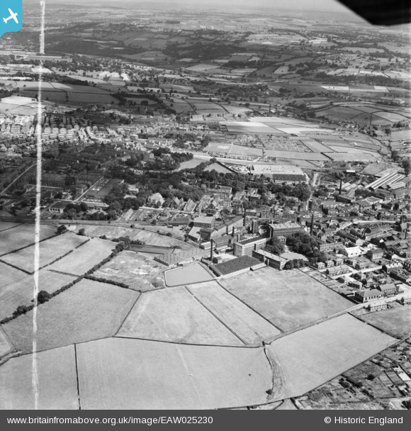
EAW025230 ENGLAND (1949). The Leigh Worsted Mills, Pudsey, from the south, 1949. This image was marked by Aerofilms Ltd for photo editing.
© Copyright OpenStreetMap contributors and licensed by the OpenStreetMap Foundation. 2025. Cartography is licensed as CC BY-SA.
Nearby Images (16)
Details
| Title | [EAW025230] The Leigh Worsted Mills, Pudsey, from the south, 1949. This image was marked by Aerofilms Ltd for photo editing. |
| Reference | EAW025230 |
| Date | 26-July-1949 |
| Link | |
| Place name | PUDSEY |
| Parish | |
| District | |
| Country | ENGLAND |
| Easting / Northing | 421821, 433966 |
| Longitude / Latitude | -1.6686498319947, 53.801322697129 |
| National Grid Reference | SE218340 |


![[EAW025230] The Leigh Worsted Mills, Pudsey, from the south, 1949. This image was marked by Aerofilms Ltd for photo editing.](http://britainfromabove.org.uk/sites/all/libraries/aerofilms-images/public/100x100/EAW/025/EAW025230.jpg)
![[EAW025239] The Leigh Worsted Mills and the surrounding area, Pudsey, 1949. This image was marked by Aerofilms Ltd for photo editing.](http://britainfromabove.org.uk/sites/all/libraries/aerofilms-images/public/100x100/EAW/025/EAW025239.jpg)
![[EAW025231] The Leigh Worsted Mills, Pudsey, from the south, 1949](http://britainfromabove.org.uk/sites/all/libraries/aerofilms-images/public/100x100/EAW/025/EAW025231.jpg)
![[EAW025236] The Leigh Worsted Mills and the surrounding area, Pudsey, 1949. This image was marked by Aerofilms Ltd for photo editing.](http://britainfromabove.org.uk/sites/all/libraries/aerofilms-images/public/100x100/EAW/025/EAW025236.jpg)
![[EAW025234] The Leigh Worsted Mills and the surrounding area, Pudsey, from the east, 1949](http://britainfromabove.org.uk/sites/all/libraries/aerofilms-images/public/100x100/EAW/025/EAW025234.jpg)
![[EAW031367] Leigh Mills and environs, Stanningley, 1950. This image was marked by Aerofilms Ltd for photo editing.](http://britainfromabove.org.uk/sites/all/libraries/aerofilms-images/public/100x100/EAW/031/EAW031367.jpg)
![[EAW031366] Leigh Mills and environs, Stanningley, 1950. This image was marked by Aerofilms Ltd for photo editing.](http://britainfromabove.org.uk/sites/all/libraries/aerofilms-images/public/100x100/EAW/031/EAW031366.jpg)
![[EAW031365] Leigh Mills and environs, Stanningley, 1950. This image was marked by Aerofilms Ltd for photo editing.](http://britainfromabove.org.uk/sites/all/libraries/aerofilms-images/public/100x100/EAW/031/EAW031365.jpg)
![[EAW031364] Leigh Mills, Bradford Road and environs, Stanningley, 1950. This image was marked by Aerofilms Ltd for photo editing.](http://britainfromabove.org.uk/sites/all/libraries/aerofilms-images/public/100x100/EAW/031/EAW031364.jpg)
![[EAW031368] Leigh Mills and environs, Stanningley, 1950. This image was marked by Aerofilms Ltd for photo editing.](http://britainfromabove.org.uk/sites/all/libraries/aerofilms-images/public/100x100/EAW/031/EAW031368.jpg)
![[EAW025233] The Leigh Worsted Mills and the surrounding area, Pudsey, from the north-east, 1949. This image was marked by Aerofilms Ltd for photo editing.](http://britainfromabove.org.uk/sites/all/libraries/aerofilms-images/public/100x100/EAW/025/EAW025233.jpg)
![[EAW031369] Leigh Mills, Stanningley, 1950. This image was marked by Aerofilms Ltd for photo editing.](http://britainfromabove.org.uk/sites/all/libraries/aerofilms-images/public/100x100/EAW/031/EAW031369.jpg)
![[EPW023834] Leigh Mills, Stanningley, 1928](http://britainfromabove.org.uk/sites/all/libraries/aerofilms-images/public/100x100/EPW/023/EPW023834.jpg)
![[EAW031362] Leigh Mills, Stanningley, 1950. This image was marked by Aerofilms Ltd for photo editing.](http://britainfromabove.org.uk/sites/all/libraries/aerofilms-images/public/100x100/EAW/031/EAW031362.jpg)
![[EAW025235] The Leigh Worsted Mills, Pudsey, 1949](http://britainfromabove.org.uk/sites/all/libraries/aerofilms-images/public/100x100/EAW/025/EAW025235.jpg)
![[EAW031363] Leigh Mills, Stanningley, 1950. This image was marked by Aerofilms Ltd for photo editing.](http://britainfromabove.org.uk/sites/all/libraries/aerofilms-images/public/100x100/EAW/031/EAW031363.jpg)
