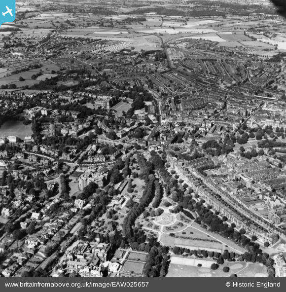
EAW025657 ENGLAND (1949). Valley Gardens and the town, Harrogate, 1949. This image has been produced from a print.
© Copyright OpenStreetMap contributors and licensed by the OpenStreetMap Foundation. 2025. Cartography is licensed as CC BY-SA.
Nearby Images (19)
Details
| Title | [EAW025657] Valley Gardens and the town, Harrogate, 1949. This image has been produced from a print. |
| Reference | EAW025657 |
| Date | 3-August-1949 |
| Link | |
| Place name | HARROGATE |
| Parish | |
| District | |
| Country | ENGLAND |
| Easting / Northing | 429832, 455427 |
| Longitude / Latitude | -1.5449157661359, 53.993828893862 |
| National Grid Reference | SE298554 |
Pins
Be the first to add a comment to this image!


![[EAW025657] Valley Gardens and the town, Harrogate, 1949. This image has been produced from a print.](http://britainfromabove.org.uk/sites/all/libraries/aerofilms-images/public/100x100/EAW/025/EAW025657.jpg)
![[EPW043182] Harrogate, 1933](http://britainfromabove.org.uk/sites/all/libraries/aerofilms-images/public/100x100/EPW/043/EPW043182.jpg)
![[EPW043181] Harrogate, 1933](http://britainfromabove.org.uk/sites/all/libraries/aerofilms-images/public/100x100/EPW/043/EPW043181.jpg)
![[EPW043183] Harrogate, 1933](http://britainfromabove.org.uk/sites/all/libraries/aerofilms-images/public/100x100/EPW/043/EPW043183.jpg)
![[EAW044403] The Old Swan Hotel, Harrogate, 1952. This image was marked by Aerofilms Ltd for photo editing.](http://britainfromabove.org.uk/sites/all/libraries/aerofilms-images/public/100x100/EAW/044/EAW044403.jpg)
![[EAW044406] The Old Swan Hotel, Harrogate, 1952. This image was marked by Aerofilms Ltd for photo editing.](http://britainfromabove.org.uk/sites/all/libraries/aerofilms-images/public/100x100/EAW/044/EAW044406.jpg)
![[EAW044404] The Old Swan Hotel, Harrogate, 1952. This image was marked by Aerofilms Ltd for photo editing.](http://britainfromabove.org.uk/sites/all/libraries/aerofilms-images/public/100x100/EAW/044/EAW044404.jpg)
![[EAW025652] The town, Harrogate, 1949](http://britainfromabove.org.uk/sites/all/libraries/aerofilms-images/public/100x100/EAW/025/EAW025652.jpg)
![[EAW044407] The Old Swan Hotel, Harrogate, 1952. This image was marked by Aerofilms Ltd for photo editing.](http://britainfromabove.org.uk/sites/all/libraries/aerofilms-images/public/100x100/EAW/044/EAW044407.jpg)
![[EPW016248] The Royal Hall and Royal Spa Concert Rooms, Harrogate, 1926](http://britainfromabove.org.uk/sites/all/libraries/aerofilms-images/public/100x100/EPW/016/EPW016248.jpg)
![[EAW044405] The Old Swan Hotel and environs, Harrogate, 1952. This image was marked by Aerofilms Ltd for photo editing.](http://britainfromabove.org.uk/sites/all/libraries/aerofilms-images/public/100x100/EAW/044/EAW044405.jpg)
![[EPW023542] The Royal Hall, Hotel Majestic and environs, Harrogate, 1928](http://britainfromabove.org.uk/sites/all/libraries/aerofilms-images/public/100x100/EPW/023/EPW023542.jpg)
![[EPW023543] The Royal Hall, Hotel Majestic and environs, Harrogate, 1928](http://britainfromabove.org.uk/sites/all/libraries/aerofilms-images/public/100x100/EPW/023/EPW023543.jpg)
![[EPW023545] The Royal Hall, Hotel Majestic and environs, Harrogate, 1928](http://britainfromabove.org.uk/sites/all/libraries/aerofilms-images/public/100x100/EPW/023/EPW023545.jpg)
![[EPW043177] Valley Gardens, Harrogate, 1933](http://britainfromabove.org.uk/sites/all/libraries/aerofilms-images/public/100x100/EPW/043/EPW043177.jpg)
![[EPW043179] Valley Gardens, Harrogate, 1933](http://britainfromabove.org.uk/sites/all/libraries/aerofilms-images/public/100x100/EPW/043/EPW043179.jpg)
![[EPW043180] Valley Gardens, Harrogate, 1933](http://britainfromabove.org.uk/sites/all/libraries/aerofilms-images/public/100x100/EPW/043/EPW043180.jpg)
![[EPW023544] The Royal Hall, Hotel Majestic and environs, Harrogate, 1928](http://britainfromabove.org.uk/sites/all/libraries/aerofilms-images/public/100x100/EPW/023/EPW023544.jpg)
![[EPW023553] The Stray, war memorial and environs, Harrogate, 1928](http://britainfromabove.org.uk/sites/all/libraries/aerofilms-images/public/100x100/EPW/023/EPW023553.jpg)