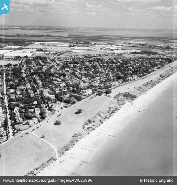
EAW025896 ENGLAND (1949). The Esplanade and town, Frinton-On-Sea, from the south-east, 1949
© Copyright OpenStreetMap contributors and licensed by the OpenStreetMap Foundation. 2025. Cartography is licensed as CC BY-SA.
Nearby Images (9)
Details
| Title | [EAW025896] The Esplanade and town, Frinton-On-Sea, from the south-east, 1949 |
| Reference | EAW025896 |
| Date | 10-August-1949 |
| Link | |
| Place name | FRINTON-ON-SEA |
| Parish | FRINTON AND WALTON |
| District | |
| Country | ENGLAND |
| Easting / Northing | 623851, 219340 |
| Longitude / Latitude | 1.248969431338, 51.827305561243 |
| National Grid Reference | TM239193 |
Pins
 Matt Aldred edob.mattaldred.com |
Tuesday 1st of December 2020 08:30:52 PM | |
 Matt Aldred edob.mattaldred.com |
Tuesday 1st of December 2020 08:30:05 PM | |
 Matt Aldred edob.mattaldred.com |
Tuesday 1st of December 2020 08:29:53 PM | |
 Chris Kolonko |
Saturday 16th of September 2017 07:41:02 PM | |
 cptpies |
Friday 23rd of October 2015 12:32:32 PM |
User Comment Contributions
 cptpies |
Friday 23rd of October 2015 12:33:54 PM |


![[EAW025896] The Esplanade and town, Frinton-On-Sea, from the south-east, 1949](http://britainfromabove.org.uk/sites/all/libraries/aerofilms-images/public/100x100/EAW/025/EAW025896.jpg)
![[EPW011636] The Greensward, Frinton-On-Sea, 1924. This image has been produced from a print.](http://britainfromabove.org.uk/sites/all/libraries/aerofilms-images/public/100x100/EPW/011/EPW011636.jpg)
![[EPW011633] The town, Frinton-On-Sea, from the south, 1924. This image has been produced from a print.](http://britainfromabove.org.uk/sites/all/libraries/aerofilms-images/public/100x100/EPW/011/EPW011633.jpg)
![[EPW041407] St Mary's Church and environs, Frinton-On-Sea, 1933](http://britainfromabove.org.uk/sites/all/libraries/aerofilms-images/public/100x100/EPW/041/EPW041407.jpg)
![[EAW054838] The Esplanade and Frinton Cliffs, Frinton-On-Sea, 1954. This image was modified by the Aerofilms Ltd Artists' Department.](http://britainfromabove.org.uk/sites/all/libraries/aerofilms-images/public/100x100/EAW/054/EAW054838.jpg)
![[EPW011634] The town, Frinton-On-Sea, from the south-west, 1924. This image has been produced from a print.](http://britainfromabove.org.uk/sites/all/libraries/aerofilms-images/public/100x100/EPW/011/EPW011634.jpg)
![[EPW041406] The Grand Hotel and environs, Frinton-On-Sea, 1933](http://britainfromabove.org.uk/sites/all/libraries/aerofilms-images/public/100x100/EPW/041/EPW041406.jpg)
![[EAW025897] The seafront looking towards Walton Pier, Frinton-On-Sea, from the south-west, 1949](http://britainfromabove.org.uk/sites/all/libraries/aerofilms-images/public/100x100/EAW/025/EAW025897.jpg)
![[EPW011635] The Greensward, Frinton-On-Sea, 1924. This image has been produced from a print.](http://britainfromabove.org.uk/sites/all/libraries/aerofilms-images/public/100x100/EPW/011/EPW011635.jpg)
