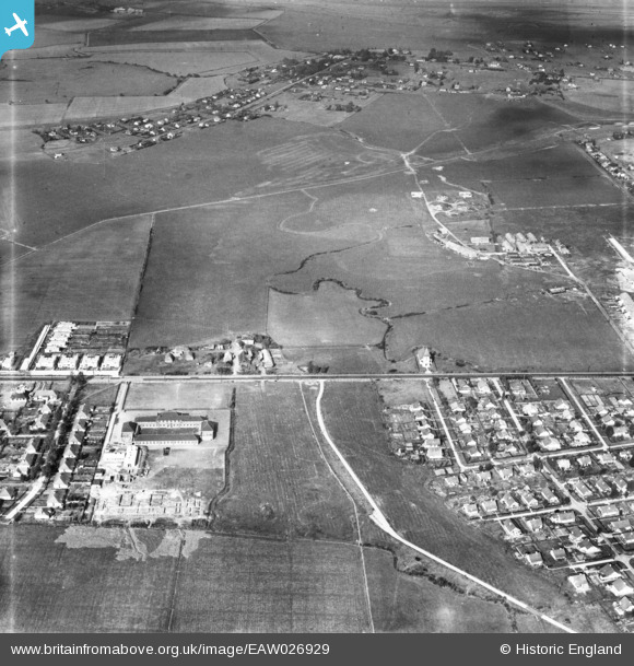
EAW026929 ENGLAND (1949). Canvey County Junior School, Southwick Farm and the surrounding area, Canvey Island, 1949
© Copyright OpenStreetMap contributors and licensed by the OpenStreetMap Foundation. 2025. Cartography is licensed as CC BY-SA.
Nearby Images (6)
Details
| Title | [EAW026929] Canvey County Junior School, Southwick Farm and the surrounding area, Canvey Island, 1949 |
| Reference | EAW026929 |
| Date | 2-October-1949 |
| Link | |
| Place name | CANVEY ISLAND |
| Parish | CANVEY ISLAND |
| District | |
| Country | ENGLAND |
| Easting / Northing | 578657, 183373 |
| Longitude / Latitude | 0.57543334345624, 51.520496097516 |
| National Grid Reference | TQ787834 |
Pins
 redmist |
Wednesday 1st of February 2023 11:22:26 PM | |
 redmist |
Wednesday 1st of February 2023 11:21:49 PM |


![[EAW026929] Canvey County Junior School, Southwick Farm and the surrounding area, Canvey Island, 1949](http://britainfromabove.org.uk/sites/all/libraries/aerofilms-images/public/100x100/EAW/026/EAW026929.jpg)
![[EAW045314] Fields and housing around Long Road and Southwick Farm, Canvey Island, 1952](http://britainfromabove.org.uk/sites/all/libraries/aerofilms-images/public/100x100/EAW/045/EAW045314.jpg)
![[EAW045311] The Catholic Church of our Lady and the English Martyrs and surrounding fields and housing off Long Road, Canvey Island, 1952](http://britainfromabove.org.uk/sites/all/libraries/aerofilms-images/public/100x100/EAW/045/EAW045311.jpg)
![[EAW045312] The fields adjacent to Miramar Avenue, Canvey Island, 1952](http://britainfromabove.org.uk/sites/all/libraries/aerofilms-images/public/100x100/EAW/045/EAW045312.jpg)
![[EAW045331] Long Road and the residential area around The Lake, Canvey Island, 1952](http://britainfromabove.org.uk/sites/all/libraries/aerofilms-images/public/100x100/EAW/045/EAW045331.jpg)
![[EAW051028] Thorney Bay Road and environs, Canvey Island, 1953](http://britainfromabove.org.uk/sites/all/libraries/aerofilms-images/public/100x100/EAW/051/EAW051028.jpg)