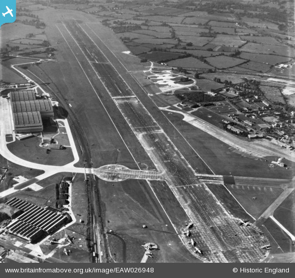
EAW026948 ENGLAND (1949). Bristol Filton Airport, Filton, from the south-east, 1949. This image has been produced from a print.
© Copyright OpenStreetMap contributors and licensed by the OpenStreetMap Foundation. 2025. Cartography is licensed as CC BY-SA.
Nearby Images (18)
Details
| Title | [EAW026948] Bristol Filton Airport, Filton, from the south-east, 1949. This image has been produced from a print. |
| Reference | EAW026948 |
| Date | 4-October-1949 |
| Link | |
| Place name | FILTON |
| Parish | FILTON |
| District | |
| Country | ENGLAND |
| Easting / Northing | 360072, 180125 |
| Longitude / Latitude | -2.5755118526345, 51.518151428799 |
| National Grid Reference | ST601801 |
Pins
 redmist |
Sunday 7th of November 2021 10:58:20 PM | |
 redmist |
Sunday 7th of November 2021 10:52:42 PM | |
 redmist |
Sunday 7th of November 2021 10:33:19 PM | |
 redmist |
Sunday 7th of November 2021 09:30:17 PM | |
 redmist |
Sunday 7th of November 2021 09:16:17 PM | |
 redmist |
Sunday 7th of November 2021 09:15:24 PM | |
 redmist |
Sunday 7th of November 2021 09:14:42 PM | |
 redmist |
Saturday 6th of November 2021 11:34:45 PM |


![[EAW026948] Bristol Filton Airport, Filton, from the south-east, 1949. This image has been produced from a print.](http://britainfromabove.org.uk/sites/all/libraries/aerofilms-images/public/100x100/EAW/026/EAW026948.jpg)
![[EAW004176] Bristol Filton Airport showing the main runway being extended, Filton, 1947](http://britainfromabove.org.uk/sites/all/libraries/aerofilms-images/public/100x100/EAW/004/EAW004176.jpg)
![[EAW026947] Bristol Filton Airport, Filton, from the east, 1949. This image has been produced from a print.](http://britainfromabove.org.uk/sites/all/libraries/aerofilms-images/public/100x100/EAW/026/EAW026947.jpg)
![[EAW003554] The east end of Bristol Filton Airport under construction, Filton, 1947](http://britainfromabove.org.uk/sites/all/libraries/aerofilms-images/public/100x100/EAW/003/EAW003554.jpg)
![[EAW009939] Bristol Filton Airport under construction, Filton, 1947](http://britainfromabove.org.uk/sites/all/libraries/aerofilms-images/public/100x100/EAW/009/EAW009939.jpg)
![[EAW007137] Bristol Filton Airport under construction, Filton, from the east, 1947](http://britainfromabove.org.uk/sites/all/libraries/aerofilms-images/public/100x100/EAW/007/EAW007137.jpg)
![[EAW009941] Bristol Filton Airport under construction, Filton, from the east, 1947](http://britainfromabove.org.uk/sites/all/libraries/aerofilms-images/public/100x100/EAW/009/EAW009941.jpg)
![[EAW013920] Bristol Filton Airport, Filton, 1948. This image has been produced from a print.](http://britainfromabove.org.uk/sites/all/libraries/aerofilms-images/public/100x100/EAW/013/EAW013920.jpg)
![[EAW007135] The eastern end of the main runway at Bristol Filton Airport under construction, Filton, 1947](http://britainfromabove.org.uk/sites/all/libraries/aerofilms-images/public/100x100/EAW/007/EAW007135.jpg)
![[EAW007146] Bristol Filton Airport under construction, Filton, from the east, 1947](http://britainfromabove.org.uk/sites/all/libraries/aerofilms-images/public/100x100/EAW/007/EAW007146.jpg)
![[EAW009942] Bristol Filton Airport under construction, Filton, from the east, 1947](http://britainfromabove.org.uk/sites/all/libraries/aerofilms-images/public/100x100/EAW/009/EAW009942.jpg)
![[EAW009940] Bristol Filton Airport under construction, Filton, 1947](http://britainfromabove.org.uk/sites/all/libraries/aerofilms-images/public/100x100/EAW/009/EAW009940.jpg)
![[EAW012430] Bristol Filton Airport under construction, Filton, 1947](http://britainfromabove.org.uk/sites/all/libraries/aerofilms-images/public/100x100/EAW/012/EAW012430.jpg)
![[EAW009943] Bristol Filton Airport under construction, Filton, 1947](http://britainfromabove.org.uk/sites/all/libraries/aerofilms-images/public/100x100/EAW/009/EAW009943.jpg)
![[EAW013919] Bristol Filton Airport, Filton, from the east, 1948](http://britainfromabove.org.uk/sites/all/libraries/aerofilms-images/public/100x100/EAW/013/EAW013919.jpg)
![[EPW029358] Bristol Bulldog during a test for the Latvian Air Force at Filton Aerodrome, Filton, 1929](http://britainfromabove.org.uk/sites/all/libraries/aerofilms-images/public/100x100/EPW/029/EPW029358.jpg)
![[EAW009944] Bristol Filton Airport under construction, Patchway, 1947](http://britainfromabove.org.uk/sites/all/libraries/aerofilms-images/public/100x100/EAW/009/EAW009944.jpg)
![[EAW013915] Bristol Filton Airport, Filton, from the east, 1948. This image has been produced from a print.](http://britainfromabove.org.uk/sites/all/libraries/aerofilms-images/public/100x100/EAW/013/EAW013915.jpg)