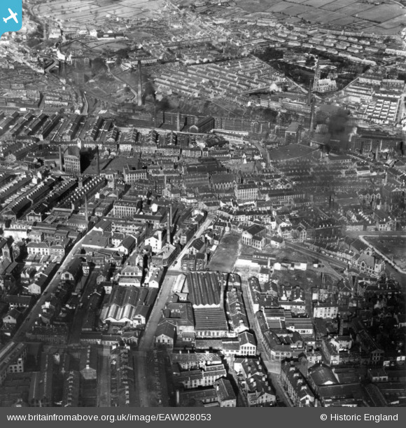
EAW028053 ENGLAND (1950). The town, Halifax, 1950. This image has been produced from a print.
© Copyright OpenStreetMap contributors and licensed by the OpenStreetMap Foundation. 2024. Cartography is licensed as CC BY-SA.
Nearby Images (16)
Details
| Title | [EAW028053] The town, Halifax, 1950. This image has been produced from a print. |
| Reference | EAW028053 |
| Date | 21-February-1950 |
| Link | |
| Place name | HALIFAX |
| Parish | |
| District | |
| Country | ENGLAND |
| Easting / Northing | 408954, 425382 |
| Longitude / Latitude | -1.8642822118699, 53.724541410436 |
| National Grid Reference | SE090254 |


![[EAW028053] The town, Halifax, 1950. This image has been produced from a print.](http://britainfromabove.org.uk/sites/all/libraries/aerofilms-images/public/100x100/EAW/028/EAW028053.jpg)
![[EAW030673] Keighley Mill and Pellon Lane, Halifax, 1950. This image was marked by Aerofilms Ltd for photo editing.](http://britainfromabove.org.uk/sites/all/libraries/aerofilms-images/public/100x100/EAW/030/EAW030673.jpg)
![[EAW030679] Keighley Mill and Pellon Lane, Halifax, 1950. This image was marked by Aerofilms Ltd for photo editing.](http://britainfromabove.org.uk/sites/all/libraries/aerofilms-images/public/100x100/EAW/030/EAW030679.jpg)
![[EAW030676] Keighley Mill, Halifax, 1950. This image was marked by Aerofilms Ltd for photo editing.](http://britainfromabove.org.uk/sites/all/libraries/aerofilms-images/public/100x100/EAW/030/EAW030676.jpg)
![[EAW030681] Keighley Mill, Halifax, 1950. This image was marked by Aerofilms Ltd for photo editing.](http://britainfromabove.org.uk/sites/all/libraries/aerofilms-images/public/100x100/EAW/030/EAW030681.jpg)
![[EAW030677] Keighley Mill, Halifax, 1950. This image was marked by Aerofilms Ltd for photo editing.](http://britainfromabove.org.uk/sites/all/libraries/aerofilms-images/public/100x100/EAW/030/EAW030677.jpg)
![[EAW030675] Gibbet Street and Keighley Mill, Halifax, 1950. This image was marked by Aerofilms Ltd for photo editing.](http://britainfromabove.org.uk/sites/all/libraries/aerofilms-images/public/100x100/EAW/030/EAW030675.jpg)
![[EAW030680] Keighley Mill and environs, Halifax, 1950. This image was marked by Aerofilms Ltd for photo editing.](http://britainfromabove.org.uk/sites/all/libraries/aerofilms-images/public/100x100/EAW/030/EAW030680.jpg)
![[EAW030674] Bedford Street North and Keighley Mill, Halifax, 1950. This image was marked by Aerofilms Ltd for photo editing.](http://britainfromabove.org.uk/sites/all/libraries/aerofilms-images/public/100x100/EAW/030/EAW030674.jpg)
![[EAW030678] Keighley Mill, Halifax, 1950](http://britainfromabove.org.uk/sites/all/libraries/aerofilms-images/public/100x100/EAW/030/EAW030678.jpg)
![[EAW028059] Barum Top, Bull Green and environs, Halifax, 1950](http://britainfromabove.org.uk/sites/all/libraries/aerofilms-images/public/100x100/EAW/028/EAW028059.jpg)
![[EPW036849] Hope Streetand environs, Halifax, 1931](http://britainfromabove.org.uk/sites/all/libraries/aerofilms-images/public/100x100/EPW/036/EPW036849.jpg)
![[EPW057283] The town centre, Halifax, 1938](http://britainfromabove.org.uk/sites/all/libraries/aerofilms-images/public/100x100/EPW/057/EPW057283.jpg)
![[EPW036846] Rhodes Street, Gibbet Street and environs, Halifax, 1931](http://britainfromabove.org.uk/sites/all/libraries/aerofilms-images/public/100x100/EPW/036/EPW036846.jpg)
![[EPW024491] Barum Top, Bull Green and environs, Halifax, 1928.](http://britainfromabove.org.uk/sites/all/libraries/aerofilms-images/public/100x100/EPW/024/EPW024491.jpg)
![[EAW015958] The Richard Whitaker & Sons Ltd Brewery on Corporation Street, Halifax, 1948. This image has been produced from a print.](http://britainfromabove.org.uk/sites/all/libraries/aerofilms-images/public/100x100/EAW/015/EAW015958.jpg)
