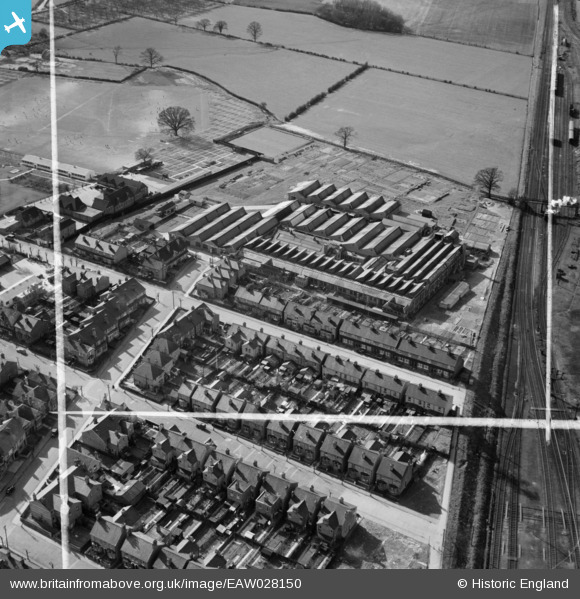
EAW028150 ENGLAND (1950). The Brown Knight and Truscott Ltd Printing Works, Tonbridge, 1950. This image was marked by Aerofilms Ltd for photo editing.
© Copyright OpenStreetMap contributors and licensed by the OpenStreetMap Foundation. 2025. Cartography is licensed as CC BY-SA.
Nearby Images (13)
Details
| Title | [EAW028150] The Brown Knight and Truscott Ltd Printing Works, Tonbridge, 1950. This image was marked by Aerofilms Ltd for photo editing. |
| Reference | EAW028150 |
| Date | 15-March-1950 |
| Link | |
| Place name | TONBRIDGE |
| Parish | |
| District | |
| Country | ENGLAND |
| Easting / Northing | 558242, 145943 |
| Longitude / Latitude | 0.26475253529616, 51.190253109853 |
| National Grid Reference | TQ582459 |
Pins
 Sparky |
Sunday 3rd of September 2017 07:35:41 PM |


![[EAW028150] The Brown Knight and Truscott Ltd Printing Works, Tonbridge, 1950. This image was marked by Aerofilms Ltd for photo editing.](http://britainfromabove.org.uk/sites/all/libraries/aerofilms-images/public/100x100/EAW/028/EAW028150.jpg)
![[EAW028154] The Brown Knight and Truscott Ltd Printing Works, Tonbridge, 1950. This image has been produced from a damaged negative.](http://britainfromabove.org.uk/sites/all/libraries/aerofilms-images/public/100x100/EAW/028/EAW028154.jpg)
![[EPW062773] The Brown, Knight and Truscott Ltd Dowgate Printing Works, Tonbridge, 1939](http://britainfromabove.org.uk/sites/all/libraries/aerofilms-images/public/100x100/EPW/062/EPW062773.jpg)
![[EAW028149] The Brown Knight and Truscott Ltd Printing Works, Tonbridge, 1950. This image was marked by Aerofilms Ltd for photo editing.](http://britainfromabove.org.uk/sites/all/libraries/aerofilms-images/public/100x100/EAW/028/EAW028149.jpg)
![[EAW028148] The Brown Knight and Truscott Ltd Printing Works, Tonbridge, 1950. This image was marked by Aerofilms Ltd for photo editing.](http://britainfromabove.org.uk/sites/all/libraries/aerofilms-images/public/100x100/EAW/028/EAW028148.jpg)
![[EAW028147] The Brown Knight and Truscott Ltd Printing Works, Tonbridge, 1950. This image was marked by Aerofilms Ltd for photo editing.](http://britainfromabove.org.uk/sites/all/libraries/aerofilms-images/public/100x100/EAW/028/EAW028147.jpg)
![[EPW062772] The Brown, Knight and Truscott Dowgate Ltd Printing Works, Tonbridge, 1939](http://britainfromabove.org.uk/sites/all/libraries/aerofilms-images/public/100x100/EPW/062/EPW062772.jpg)
![[EAW028151] The Brown Knight and Truscott Ltd Printing Works, Tonbridge, 1950. This image was marked by Aerofilms Ltd for photo editing.](http://britainfromabove.org.uk/sites/all/libraries/aerofilms-images/public/100x100/EAW/028/EAW028151.jpg)
![[EAW028146] The Brown Knight and Truscott Ltd Printing Works, Tonbridge, 1950. This image was marked by Aerofilms Ltd for photo editing.](http://britainfromabove.org.uk/sites/all/libraries/aerofilms-images/public/100x100/EAW/028/EAW028146.jpg)
![[EPW062774] The Brown, Knight and Truscott Dowgate Ltd Printing Works, Tonbridge, 1939](http://britainfromabove.org.uk/sites/all/libraries/aerofilms-images/public/100x100/EPW/062/EPW062774.jpg)
![[EAW028153] The Brown Knight and Truscott Ltd Printing Works, Tonbridge, 1950. This image has been produced from a damaged negative.](http://britainfromabove.org.uk/sites/all/libraries/aerofilms-images/public/100x100/EAW/028/EAW028153.jpg)
![[EAW028152] The Brown Knight and Truscott Ltd Printing Works, Tonbridge, 1950. This image was marked by Aerofilms Ltd for photo editing.](http://britainfromabove.org.uk/sites/all/libraries/aerofilms-images/public/100x100/EAW/028/EAW028152.jpg)
![[EPW062771] The Brown, Knight and Truscott Ltd Dowgate Printing Works, Tonbridge, 1939](http://britainfromabove.org.uk/sites/all/libraries/aerofilms-images/public/100x100/EPW/062/EPW062771.jpg)