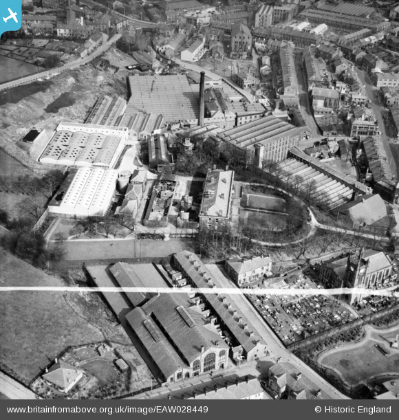
EAW028449 ENGLAND (1950). Holly Mount and surrounding mills, Rawtenstall, 1950. This image was marked by Aerofilms Ltd for photo editing.
© Copyright OpenStreetMap contributors and licensed by the OpenStreetMap Foundation. 2024. Cartography is licensed as CC BY-SA.
Nearby Images (9)
Details
| Title | [EAW028449] Holly Mount and surrounding mills, Rawtenstall, 1950. This image was marked by Aerofilms Ltd for photo editing. |
| Reference | EAW028449 |
| Date | 25-March-1950 |
| Link | |
| Place name | RAWTENSTALL |
| Parish | |
| District | |
| Country | ENGLAND |
| Easting / Northing | 381067, 422885 |
| Longitude / Latitude | -2.2868174773875, 53.701829058321 |
| National Grid Reference | SD811229 |
Pins
 wadey |
Wednesday 1st of October 2014 11:18:41 PM | |
 wadey |
Wednesday 1st of October 2014 11:18:01 PM | |
 wadey |
Wednesday 1st of October 2014 11:17:19 PM | |
 wadey |
Wednesday 1st of October 2014 11:16:41 PM | |
 wadey |
Wednesday 1st of October 2014 11:16:06 PM | |
 wadey |
Wednesday 1st of October 2014 11:15:39 PM | |
 wadey |
Wednesday 1st of October 2014 11:14:28 PM | |
 wadey |
Wednesday 1st of October 2014 11:13:45 PM | |
 wadey |
Wednesday 1st of October 2014 11:13:03 PM | |
 wadey |
Wednesday 1st of October 2014 11:12:18 PM | |
 wadey |
Wednesday 1st of October 2014 11:11:21 PM |


![[EAW028449] Holly Mount and surrounding mills, Rawtenstall, 1950. This image was marked by Aerofilms Ltd for photo editing.](http://britainfromabove.org.uk/sites/all/libraries/aerofilms-images/public/100x100/EAW/028/EAW028449.jpg)
![[EAW028443] Holly Mount and surrounding mills, Rawtenstall, 1950. This image was marked by Aerofilms Ltd for photo editing.](http://britainfromabove.org.uk/sites/all/libraries/aerofilms-images/public/100x100/EAW/028/EAW028443.jpg)
![[EAW028447] Holly Mount and surrounding mills, Rawtenstall, 1950. This image was marked by Aerofilms Ltd for photo editing.](http://britainfromabove.org.uk/sites/all/libraries/aerofilms-images/public/100x100/EAW/028/EAW028447.jpg)
![[EAW028445] Lower Mill, Holly Mount and environs, Rawtenstall, 1950. This image was marked by Aerofilms Ltd for photo editing.](http://britainfromabove.org.uk/sites/all/libraries/aerofilms-images/public/100x100/EAW/028/EAW028445.jpg)
![[EAW028451] Lower Mill and Holly Mount, Rawtenstall, 1950. This image was marked by Aerofilms Ltd for photo editing.](http://britainfromabove.org.uk/sites/all/libraries/aerofilms-images/public/100x100/EAW/028/EAW028451.jpg)
![[EAW028446] Lower Mill, Holly Mount and environs, Rawtenstall, 1950. This image was marked by Aerofilms Ltd for photo editing.](http://britainfromabove.org.uk/sites/all/libraries/aerofilms-images/public/100x100/EAW/028/EAW028446.jpg)
![[EAW028450] Lower Mill, Holly Mount and environs, Rawtenstall, 1950. This image was marked by Aerofilms Ltd for photo editing.](http://britainfromabove.org.uk/sites/all/libraries/aerofilms-images/public/100x100/EAW/028/EAW028450.jpg)
![[EAW028448] Lower Mill, Rawtenstall, 1950. This image was marked by Aerofilms Ltd for photo editing.](http://britainfromabove.org.uk/sites/all/libraries/aerofilms-images/public/100x100/EAW/028/EAW028448.jpg)
![[EAW028444] Lower Mill, Rawtenstall, 1950. This image was marked by Aerofilms Ltd for photo editing.](http://britainfromabove.org.uk/sites/all/libraries/aerofilms-images/public/100x100/EAW/028/EAW028444.jpg)