
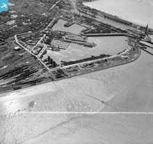
EAW029007 ENGLAND (1950). Grimsby Fish Docks, Grimsby, 1950. This image was marked by Aerofilms Ltd for photo editing.

© Copyright OpenStreetMap contributors and licensed by the OpenStreetMap Foundation. 2025. Cartography is licensed as CC BY-SA.
Nearby Images (2)
EAW029007

EAW029008

Details
| Title | [EAW029007] Grimsby Fish Docks, Grimsby, 1950. This image was marked by Aerofilms Ltd for photo editing. |
| Reference | EAW029007 |
| Date | 10-May-1950 |
| Link | |
| Place name | GRIMSBY |
| Parish | |
| District | |
| Country | ENGLAND |
| Easting / Northing | 528671, 410977 |
| Longitude / Latitude | -0.056284950656405, 53.579338529693 |
| National Grid Reference | TA287110 |
Pins
 Matt Aldred edob.mattaldred.com |
Saturday 27th of February 2021 11:33:52 AM | |
 cptpies |
Monday 23rd of October 2017 09:53:57 AM | |
 Class31 |
Tuesday 24th of May 2016 10:21:04 PM | |
stu |
Sunday 24th of April 2016 02:32:39 PM | |
jrussill |
Wednesday 19th of November 2014 06:34:39 PM | |
Class31 |
Monday 3rd of March 2014 07:53:48 PM | |
Class31 |
Monday 3rd of March 2014 07:32:50 PM | |
Class31 |
Monday 3rd of March 2014 06:00:25 PM |

User Comment Contributions
 AA Battery - WW2 |
jrussill |
Wednesday 19th of November 2014 06:35:16 PM |