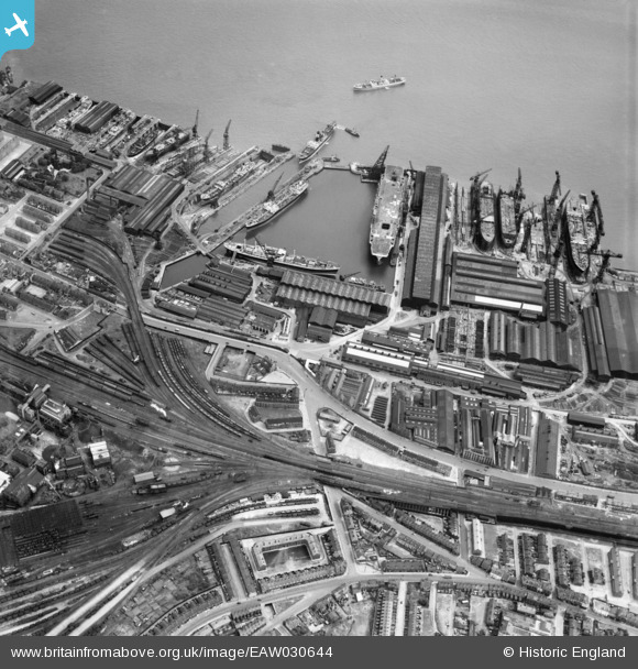
EAW030644 ENGLAND (1950). The Cammell Laird Shipbuilding and Engineering Works, Birkenhead, 1950
© Copyright OpenStreetMap contributors and licensed by the OpenStreetMap Foundation. 2024. Cartography is licensed as CC BY-SA.
Nearby Images (11)
Details
| Title | [EAW030644] The Cammell Laird Shipbuilding and Engineering Works, Birkenhead, 1950 |
| Reference | EAW030644 |
| Date | 29-June-1950 |
| Link | |
| Place name | BIRKENHEAD |
| Parish | |
| District | |
| Country | ENGLAND |
| Easting / Northing | 332732, 388068 |
| Longitude / Latitude | -3.0114786314831, 53.384904133591 |
| National Grid Reference | SJ327881 |
Pins
 David Green |
Friday 11th of January 2019 04:11:43 PM | |
 David Green |
Friday 9th of February 2018 04:07:47 PM | |
 David Green |
Friday 9th of February 2018 04:04:08 PM |


![[EAW030644] The Cammell Laird Shipbuilding and Engineering Works, Birkenhead, 1950](http://britainfromabove.org.uk/sites/all/libraries/aerofilms-images/public/100x100/EAW/030/EAW030644.jpg)
![[EAW030637] The Cammell Laird Shipbuilding and Engineering Works, Birkenhead, 1950](http://britainfromabove.org.uk/sites/all/libraries/aerofilms-images/public/100x100/EAW/030/EAW030637.jpg)
![[EAW029265] Cammell Laird and Co Ltd Shipbuilding and Engineering Works and the Graving Docks to the north of the Outer Basin, Birkenhead, 1950. This image was marked by Aerofilms Ltd for photo editing.](http://britainfromabove.org.uk/sites/all/libraries/aerofilms-images/public/100x100/EAW/029/EAW029265.jpg)
![[EAW030639] The Cammell Laird Shipbuilding and Engineering Works, Birkenhead, 1950](http://britainfromabove.org.uk/sites/all/libraries/aerofilms-images/public/100x100/EAW/030/EAW030639.jpg)
![[EAW030646] The Cammell Laird Shipbuilding and Engineering Works, Birkenhead, 1950](http://britainfromabove.org.uk/sites/all/libraries/aerofilms-images/public/100x100/EAW/030/EAW030646.jpg)
![[EAW028439] Cammell Laird's Shipbuilding and Engineering Works and King's Square, Birkenhead, 1950](http://britainfromabove.org.uk/sites/all/libraries/aerofilms-images/public/100x100/EAW/028/EAW028439.jpg)
![[EAW029267] Cammell Laird and Co Ltd Shipbuilding and Engineering Works and environs, Birkenhead, 1950](http://britainfromabove.org.uk/sites/all/libraries/aerofilms-images/public/100x100/EAW/029/EAW029267.jpg)
![[EAW029269] Cammell Laird and Co Ltd Shipbuilding and Engineering Works and environs, Birkenhead, 1950. This image was marked by Aerofilms Ltd for photo editing.](http://britainfromabove.org.uk/sites/all/libraries/aerofilms-images/public/100x100/EAW/029/EAW029269.jpg)
![[EAW029261] Cammell Laird and Co Ltd Shipbuilding and Engineering Works, Birkenhead, 1950](http://britainfromabove.org.uk/sites/all/libraries/aerofilms-images/public/100x100/EAW/029/EAW029261.jpg)
![[EAW029268] Cammell Laird and Co Ltd Shipbuilding and Engineering Works and environs, Birkenhead, 1950](http://britainfromabove.org.uk/sites/all/libraries/aerofilms-images/public/100x100/EAW/029/EAW029268.jpg)
![[EPW004021] Cammell Laird Shipbuilding and Engineering Works, Birkenhead, 1920](http://britainfromabove.org.uk/sites/all/libraries/aerofilms-images/public/100x100/EPW/004/EPW004021.jpg)