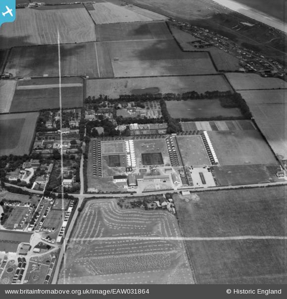
EAW031864 ENGLAND (1950). Seacroft Holiday Camp, Hemsby, 1950. This image was marked by Aerofilms Ltd for photo editing.
© Copyright OpenStreetMap contributors and licensed by the OpenStreetMap Foundation. 2025. Cartography is licensed as CC BY-SA.
Nearby Images (8)
Details
| Title | [EAW031864] Seacroft Holiday Camp, Hemsby, 1950. This image was marked by Aerofilms Ltd for photo editing. |
| Reference | EAW031864 |
| Date | 14-August-1950 |
| Link | |
| Place name | HEMSBY |
| Parish | HEMSBY |
| District | |
| Country | ENGLAND |
| Easting / Northing | 649990, 317500 |
| Longitude / Latitude | 1.700251598716, 52.697009955331 |
| National Grid Reference | TG500175 |
Pins
 Matt Aldred edob.mattaldred.com |
Tuesday 9th of March 2021 09:36:34 AM | |
 Matt Aldred edob.mattaldred.com |
Tuesday 9th of March 2021 09:31:58 AM | |
 Matt Aldred edob.mattaldred.com |
Tuesday 9th of March 2021 09:31:38 AM | |
 redmist |
Thursday 1st of October 2020 11:40:55 PM | |
 redmist |
Thursday 1st of October 2020 11:36:03 PM | |
 redmist |
Thursday 1st of October 2020 11:32:23 PM | |
 redmist |
Thursday 1st of October 2020 11:31:46 PM | |
 redmist |
Thursday 1st of October 2020 11:19:32 PM |


![[EAW031864] Seacroft Holiday Camp, Hemsby, 1950. This image was marked by Aerofilms Ltd for photo editing.](http://britainfromabove.org.uk/sites/all/libraries/aerofilms-images/public/100x100/EAW/031/EAW031864.jpg)
![[EAW031863] Seacroft Holiday Camp, Hemsby, 1950. This image was marked by Aerofilms Ltd for photo editing.](http://britainfromabove.org.uk/sites/all/libraries/aerofilms-images/public/100x100/EAW/031/EAW031863.jpg)
![[EAW031865] Seacroft Holiday Camp, Hemsby, 1950. This image was marked by Aerofilms Ltd for photo editing.](http://britainfromabove.org.uk/sites/all/libraries/aerofilms-images/public/100x100/EAW/031/EAW031865.jpg)
![[EAW031860] Seacroft Holiday Camp, Hemsby, 1950. This image was marked by Aerofilms Ltd for photo editing.](http://britainfromabove.org.uk/sites/all/libraries/aerofilms-images/public/100x100/EAW/031/EAW031860.jpg)
![[EAW031866] Seacroft Holiday Camp, Hemsby, 1950. This image was marked by Aerofilms Ltd for photo editing.](http://britainfromabove.org.uk/sites/all/libraries/aerofilms-images/public/100x100/EAW/031/EAW031866.jpg)
![[EAW031861] Seacroft Holiday Camp, Hemsby, 1950](http://britainfromabove.org.uk/sites/all/libraries/aerofilms-images/public/100x100/EAW/031/EAW031861.jpg)
![[EAW031859] Seacroft Holiday Camp, Hemsby, 1950. This image was marked by Aerofilms Ltd for photo editing.](http://britainfromabove.org.uk/sites/all/libraries/aerofilms-images/public/100x100/EAW/031/EAW031859.jpg)
![[EAW031862] Seacroft Holiday Camp, Hemsby, 1950. This image was marked by Aerofilms Ltd for photo editing.](http://britainfromabove.org.uk/sites/all/libraries/aerofilms-images/public/100x100/EAW/031/EAW031862.jpg)