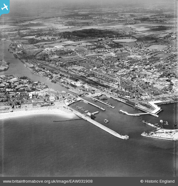
EAW031908 ENGLAND (1950). The town and the docks, Lowestoft, 1950
© Copyright OpenStreetMap contributors and licensed by the OpenStreetMap Foundation. 2025. Cartography is licensed as CC BY-SA.
Nearby Images (18)
Details
| Title | [EAW031908] The town and the docks, Lowestoft, 1950 |
| Reference | EAW031908 |
| Date | 14-August-1950 |
| Link | |
| Place name | LOWESTOFT |
| Parish | |
| District | |
| Country | ENGLAND |
| Easting / Northing | 654748, 292783 |
| Longitude / Latitude | 1.7515054223917, 52.473045373725 |
| National Grid Reference | TM547928 |
Pins
 Brightonboy |
Thursday 8th of October 2015 09:16:43 PM | |
 Brightonboy |
Thursday 8th of October 2015 09:14:15 PM | |
 Brightonboy |
Thursday 8th of October 2015 08:54:47 PM | |
 Brightonboy |
Thursday 8th of October 2015 08:53:33 PM | |
 Brightonboy |
Thursday 8th of October 2015 08:49:44 PM | |
 Brightonboy |
Thursday 8th of October 2015 08:43:04 PM | |
 Brightonboy |
Thursday 8th of October 2015 08:42:07 PM | |
 Brightonboy |
Thursday 8th of October 2015 08:40:54 PM | |
 Brightonboy |
Thursday 8th of October 2015 08:39:42 PM | |
 Brightonboy |
Thursday 8th of October 2015 08:37:53 PM | |
 Brightonboy |
Thursday 8th of October 2015 08:31:54 PM | |
 Brightonboy |
Thursday 8th of October 2015 08:30:09 PM | |
 Brightonboy |
Thursday 8th of October 2015 08:29:02 PM | |
 Brightonboy |
Thursday 8th of October 2015 08:27:32 PM | |
 thompson |
Thursday 8th of October 2015 08:24:06 PM | |
 derbyminer |
Monday 22nd of September 2014 08:29:01 PM | |
 derbyminer |
Monday 22nd of September 2014 08:28:11 PM |


![[EAW031908] The town and the docks, Lowestoft, 1950](http://britainfromabove.org.uk/sites/all/libraries/aerofilms-images/public/100x100/EAW/031/EAW031908.jpg)
![[EAW047637] The town centre including Lowestoft Central Station, Lowestoft, from the south, 1952](http://britainfromabove.org.uk/sites/all/libraries/aerofilms-images/public/100x100/EAW/047/EAW047637.jpg)
![[EAW047641] The town centre, harbour and docks, Lowestoft, 1952](http://britainfromabove.org.uk/sites/all/libraries/aerofilms-images/public/100x100/EAW/047/EAW047641.jpg)
![[EAW052979] The Inner Harbour entrance and environs, Lowestoft, 1953](http://britainfromabove.org.uk/sites/all/libraries/aerofilms-images/public/100x100/EAW/052/EAW052979.jpg)
![[EPW021250] Lowestoft Railway Station and environs, Lowestoft, 1928](http://britainfromabove.org.uk/sites/all/libraries/aerofilms-images/public/100x100/EPW/021/EPW021250.jpg)
![[EAW031909] The town and the docks, Lowestoft, 1950](http://britainfromabove.org.uk/sites/all/libraries/aerofilms-images/public/100x100/EAW/031/EAW031909.jpg)
![[EPW021242] The Inner and Outer Harbours and the town, Lowestoft, 1928](http://britainfromabove.org.uk/sites/all/libraries/aerofilms-images/public/100x100/EPW/021/EPW021242.jpg)
![[EAW025475] The South Basin and seafront, Lowestoft, from the north-east, 1949](http://britainfromabove.org.uk/sites/all/libraries/aerofilms-images/public/100x100/EAW/025/EAW025475.jpg)
![[EAW052982] The docks and harbours, Lowestoft, 1953](http://britainfromabove.org.uk/sites/all/libraries/aerofilms-images/public/100x100/EAW/052/EAW052982.jpg)
![[EPW001898] Lowestoft Harbour and Station, Lowestoft, 1920](http://britainfromabove.org.uk/sites/all/libraries/aerofilms-images/public/100x100/EPW/001/EPW001898.jpg)
![[EAW031906] The docks, Lowestoft, 1950](http://britainfromabove.org.uk/sites/all/libraries/aerofilms-images/public/100x100/EAW/031/EAW031906.jpg)
![[EAW052978] The Inner Harbour entrance and environs, Lowestoft, 1953](http://britainfromabove.org.uk/sites/all/libraries/aerofilms-images/public/100x100/EAW/052/EAW052978.jpg)
![[EPW021253] Lowestoft Railway Station and the town, 1928](http://britainfromabove.org.uk/sites/all/libraries/aerofilms-images/public/100x100/EPW/021/EPW021253.jpg)
![[EAW047640] The town centre, harbour and docks, Lowestoft, from the west, 1952](http://britainfromabove.org.uk/sites/all/libraries/aerofilms-images/public/100x100/EAW/047/EAW047640.jpg)
![[EAW052981] The docks and harbours, Lowestoft, from the south-west, 1953](http://britainfromabove.org.uk/sites/all/libraries/aerofilms-images/public/100x100/EAW/052/EAW052981.jpg)
![[EAR032727] Outer Harbour and Waveney Dock, Lowestoft, 1958](http://britainfromabove.org.uk/sites/all/libraries/aerofilms-images/public/100x100/EAR/032/EAR032727.jpg)
![[EAW047639] The Royal Hotel on South Beach, South Basin and environs, Lowestoft, 1952](http://britainfromabove.org.uk/sites/all/libraries/aerofilms-images/public/100x100/EAW/047/EAW047639.jpg)
![[EPW021243] St John's Church and the Inner Harbour, Lowestoft, 1928](http://britainfromabove.org.uk/sites/all/libraries/aerofilms-images/public/100x100/EPW/021/EPW021243.jpg)