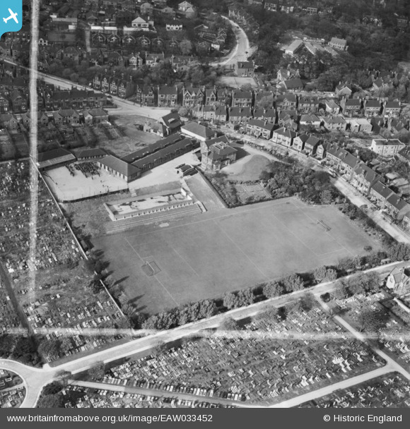
EAW033452 ENGLAND (1950). De La Salle College, Pitsmoor, 1950. This image was marked by Aerofilms Ltd for photo editing.
© Copyright OpenStreetMap contributors and licensed by the OpenStreetMap Foundation. 2025. Cartography is licensed as CC BY-SA.
Details
| Title | [EAW033452] De La Salle College, Pitsmoor, 1950. This image was marked by Aerofilms Ltd for photo editing. |
| Reference | EAW033452 |
| Date | 12-October-1950 |
| Link | |
| Place name | PITSMOOR |
| Parish | |
| District | |
| Country | ENGLAND |
| Easting / Northing | 436120, 389516 |
| Longitude / Latitude | -1.456681040025, 53.400969656037 |
| National Grid Reference | SK361895 |
Pins
 redmist |
Monday 14th of January 2019 09:49:38 AM | |
 redmist |
Monday 14th of January 2019 09:43:09 AM | |
 redmist |
Monday 14th of January 2019 09:40:10 AM | |
 attercliffe |
Sunday 3rd of January 2016 07:24:04 PM | |
 attercliffe |
Sunday 3rd of January 2016 07:23:26 PM | |
 attercliffe |
Sunday 3rd of January 2016 07:22:16 PM | |
 attercliffe |
Sunday 3rd of January 2016 07:22:15 PM | |
 attercliffe |
Sunday 3rd of January 2016 07:21:47 PM | |
 attercliffe |
Sunday 3rd of January 2016 07:21:09 PM | |
 attercliffe |
Sunday 3rd of January 2016 07:20:04 PM | |
 attercliffe |
Sunday 3rd of January 2016 07:19:30 PM |


![[EAW033452] De La Salle College, Pitsmoor, 1950. This image was marked by Aerofilms Ltd for photo editing.](http://britainfromabove.org.uk/sites/all/libraries/aerofilms-images/public/100x100/EAW/033/EAW033452.jpg)
![[EAW033455] De La Salle College and Burngreave Cemetery, Pitsmoor, 1950](http://britainfromabove.org.uk/sites/all/libraries/aerofilms-images/public/100x100/EAW/033/EAW033455.jpg)
![[EAW033453] De La Salle College and Burngreave Cemetery, Pitsmoor, 1950. This image was marked by Aerofilms Ltd for photo editing.](http://britainfromabove.org.uk/sites/all/libraries/aerofilms-images/public/100x100/EAW/033/EAW033453.jpg)
![[EAW033454] De La Salle College and Burngreave Cemetery, Pitsmoor, 1950](http://britainfromabove.org.uk/sites/all/libraries/aerofilms-images/public/100x100/EAW/033/EAW033454.jpg)