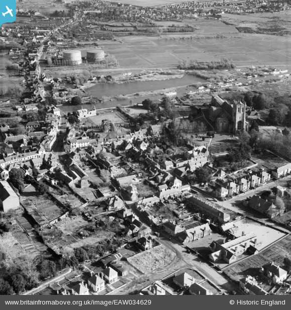
EAW034629 ENGLAND (1951). Christchurch Priory, Church Lane and environs, Christchurch, 1951
© Copyright OpenStreetMap contributors and licensed by the OpenStreetMap Foundation. 2025. Cartography is licensed as CC BY-SA.
Nearby Images (17)
Details
| Title | [EAW034629] Christchurch Priory, Church Lane and environs, Christchurch, 1951 |
| Reference | EAW034629 |
| Date | 7-February-1951 |
| Link | |
| Place name | CHRISTCHURCH |
| Parish | |
| District | |
| Country | ENGLAND |
| Easting / Northing | 415925, 92618 |
| Longitude / Latitude | -1.77432371221, 50.732386988668 |
| National Grid Reference | SZ159926 |
Pins
 Voyeur |
Monday 13th of October 2014 04:28:08 PM | |
 Voyeur |
Monday 13th of October 2014 04:27:46 PM | |
 Voyeur |
Monday 13th of October 2014 04:27:22 PM | |
 Voyeur |
Monday 13th of October 2014 04:26:10 PM | |
 Voyeur |
Monday 13th of October 2014 04:24:56 PM | |
 railwaymanx |
Friday 25th of April 2014 06:22:37 PM |


![[EAW034629] Christchurch Priory, Church Lane and environs, Christchurch, 1951](http://britainfromabove.org.uk/sites/all/libraries/aerofilms-images/public/100x100/EAW/034/EAW034629.jpg)
![[EPW037405] Christ Church, the River Stour and the town, Christchurch, 1932](http://britainfromabove.org.uk/sites/all/libraries/aerofilms-images/public/100x100/EPW/037/EPW037405.jpg)
![[EAW034631] Wick Lane, Whitehall and environs, Christchurch, 1951](http://britainfromabove.org.uk/sites/all/libraries/aerofilms-images/public/100x100/EAW/034/EAW034631.jpg)
![[EPW037406] Christ Church, the River Stour and the town, Christchurch, 1932. This image has been produced from a damaged negative.](http://britainfromabove.org.uk/sites/all/libraries/aerofilms-images/public/100x100/EPW/037/EPW037406.jpg)
![[EAW034632] Christchurch Priory and environs, Christchurch, 1951](http://britainfromabove.org.uk/sites/all/libraries/aerofilms-images/public/100x100/EAW/034/EAW034632.jpg)
![[EPW013615] Christ Church and the town, Christchurch, 1925. This image has been produced from a copy-negative.](http://britainfromabove.org.uk/sites/all/libraries/aerofilms-images/public/100x100/EPW/013/EPW013615.jpg)
![[EAW034630] Christchurch Priory and the Castle, Christchurch, 1951](http://britainfromabove.org.uk/sites/all/libraries/aerofilms-images/public/100x100/EAW/034/EAW034630.jpg)
![[EPW013614] Christ Church and the town, Christchurch, 1925. This image has been produced from a print.](http://britainfromabove.org.uk/sites/all/libraries/aerofilms-images/public/100x100/EPW/013/EPW013614.jpg)
![[EPW018171] Christ Church and environs, Christchurch, 1927](http://britainfromabove.org.uk/sites/all/libraries/aerofilms-images/public/100x100/EPW/018/EPW018171.jpg)
![[EPW037439] Christchurch Priory, Christchurch, 1932. This image has been produced from a print.](http://britainfromabove.org.uk/sites/all/libraries/aerofilms-images/public/100x100/EPW/037/EPW037439.jpg)
![[EPW013616] Christ Church and environs, Christchurch, 1925. This image has been produced from a copy-negative.](http://britainfromabove.org.uk/sites/all/libraries/aerofilms-images/public/100x100/EPW/013/EPW013616.jpg)
![[EPR000280] Christchurch Priory and the town, Christchurch, 1934](http://britainfromabove.org.uk/sites/all/libraries/aerofilms-images/public/100x100/EPR/000/EPR000280.jpg)
![[EPW018172] Christ Church and environs, Christchurch, 1927. This image has been produced from a print.](http://britainfromabove.org.uk/sites/all/libraries/aerofilms-images/public/100x100/EPW/018/EPW018172.jpg)
![[EPR000281] The River Stour, Christchurch Priory and the town, Christchurch, 1934](http://britainfromabove.org.uk/sites/all/libraries/aerofilms-images/public/100x100/EPR/000/EPR000281.jpg)
![[EAW049063] Convent Meadows, Christ Church and environs, Christchurch, 1953](http://britainfromabove.org.uk/sites/all/libraries/aerofilms-images/public/100x100/EAW/049/EAW049063.jpg)
![[EAW034633] Christchurch Priory, Convent Meadows and environs, Christchurch, 1951](http://britainfromabove.org.uk/sites/all/libraries/aerofilms-images/public/100x100/EAW/034/EAW034633.jpg)
![[EAW034634] Christchurch Priory, Convent Meadows and environs, Christchurch, 1951](http://britainfromabove.org.uk/sites/all/libraries/aerofilms-images/public/100x100/EAW/034/EAW034634.jpg)