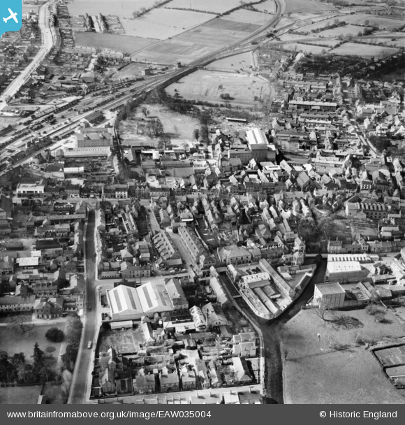
EAW035004 ENGLAND (1951). Castle Field and the town centre, Sleaford, 1951
© Copyright OpenStreetMap contributors and licensed by the OpenStreetMap Foundation. 2024. Cartography is licensed as CC BY-SA.
Nearby Images (7)
Details
| Title | [EAW035004] Castle Field and the town centre, Sleaford, 1951 |
| Reference | EAW035004 |
| Date | 20-March-1951 |
| Link | |
| Place name | SLEAFORD |
| Parish | SLEAFORD |
| District | |
| Country | ENGLAND |
| Easting / Northing | 506865, 345643 |
| Longitude / Latitude | -0.4075191669278, 52.997127762926 |
| National Grid Reference | TF069456 |
Pins
 Moonraker |
Friday 20th of October 2023 11:04:40 AM | |
 Moonraker |
Friday 20th of October 2023 10:55:35 AM | |
 FSMMF |
Thursday 15th of October 2015 07:37:11 AM | |
 bescotbeast |
Saturday 7th of February 2015 11:42:29 AM |


![[EAW035004] Castle Field and the town centre, Sleaford, 1951](http://britainfromabove.org.uk/sites/all/libraries/aerofilms-images/public/100x100/EAW/035/EAW035004.jpg)
![[EAW035003] St Denys Church and the town centre, Sleaford, 1951](http://britainfromabove.org.uk/sites/all/libraries/aerofilms-images/public/100x100/EAW/035/EAW035003.jpg)
![[EPW016183] The town centre, Sleaford, 1926](http://britainfromabove.org.uk/sites/all/libraries/aerofilms-images/public/100x100/EPW/016/EPW016183.jpg)
![[EPW013045] The town centre, Sleaford, 1925. This image has been produced from a copy-negative.](http://britainfromabove.org.uk/sites/all/libraries/aerofilms-images/public/100x100/EPW/013/EPW013045.jpg)
![[EAW035001] The Railway Station and the town centre, Sleaford, 1951](http://britainfromabove.org.uk/sites/all/libraries/aerofilms-images/public/100x100/EAW/035/EAW035001.jpg)
![[EPW016184] The town centre, Sleaford, 1926](http://britainfromabove.org.uk/sites/all/libraries/aerofilms-images/public/100x100/EPW/016/EPW016184.jpg)
![[EAW035002] St Denys Church and West Gate, Sleaford, 1951](http://britainfromabove.org.uk/sites/all/libraries/aerofilms-images/public/100x100/EAW/035/EAW035002.jpg)