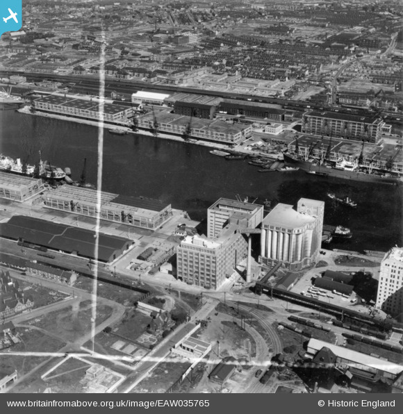
EAW035765 ENGLAND (1951). The Joseph Rank Ltd Empire Mill at Royal Victoria Dock and environs, Silvertown, 1951. This image has been produced from a print marked by Aerofilms Ltd for photo editing.
© Copyright OpenStreetMap contributors and licensed by the OpenStreetMap Foundation. 2025. Cartography is licensed as CC BY-SA.
Nearby Images (31)
Details
| Title | [EAW035765] The Joseph Rank Ltd Empire Mill at Royal Victoria Dock and environs, Silvertown, 1951. This image has been produced from a print marked by Aerofilms Ltd for photo editing. |
| Reference | EAW035765 |
| Date | 12-May-1951 |
| Link | |
| Place name | SILVERTOWN |
| Parish | |
| District | |
| Country | ENGLAND |
| Easting / Northing | 540745, 180494 |
| Longitude / Latitude | 0.028180638365899, 51.505345533923 |
| National Grid Reference | TQ407805 |
Pins
 Biff |
Saturday 14th of November 2020 07:34:58 PM | |
 Biff |
Saturday 14th of November 2020 07:34:05 PM | |
 MB |
Saturday 17th of September 2016 10:42:08 AM | |
 MB |
Saturday 17th of September 2016 10:41:15 AM | |
 MB |
Saturday 17th of September 2016 10:40:34 AM |


![[EAW035765] The Joseph Rank Ltd Empire Mill at Royal Victoria Dock and environs, Silvertown, 1951. This image has been produced from a print marked by Aerofilms Ltd for photo editing.](http://britainfromabove.org.uk/sites/all/libraries/aerofilms-images/public/100x100/EAW/035/EAW035765.jpg)
![[EPW055308] The Royal Victoria Dock, Custom House, 1937. This image has been produced from a copy-negative.](http://britainfromabove.org.uk/sites/all/libraries/aerofilms-images/public/100x100/EPW/055/EPW055308.jpg)
![[EAW035969] Empire Mills at Royal Victoria Dock, Silvertown, 1951. This image has been produced from a print marked by Aerofilms Ltd for photo editing.](http://britainfromabove.org.uk/sites/all/libraries/aerofilms-images/public/100x100/EAW/035/EAW035969.jpg)
![[EAW008822] The Royal Docks, Custom House, from the west, 1947](http://britainfromabove.org.uk/sites/all/libraries/aerofilms-images/public/100x100/EAW/008/EAW008822.jpg)
![[EAW035768] The Joseph Rank Ltd Empire Mill at Royal Victoria Dock and environs, Silvertown, 1951. This image has been produced from a print marked by Aerofilms Ltd for photo editing.](http://britainfromabove.org.uk/sites/all/libraries/aerofilms-images/public/100x100/EAW/035/EAW035768.jpg)
![[EAW035973] Empire Mills at Royal Victoria Dock, Silvertown, 1951. This image has been produced from a print marked by Aerofilms Ltd for photo editing.](http://britainfromabove.org.uk/sites/all/libraries/aerofilms-images/public/100x100/EAW/035/EAW035973.jpg)
![[EAW035974] Empire Mills at Royal Victoria Dock, Silvertown, 1951. This image has been produced from a print marked by Aerofilms Ltd for photo editing.](http://britainfromabove.org.uk/sites/all/libraries/aerofilms-images/public/100x100/EAW/035/EAW035974.jpg)
![[EAW035769] The Joseph Rank Ltd Empire Mill at Royal Victoria Dock and environs, Silvertown, 1951. This image has been produced from a print marked by Aerofilms Ltd for photo editing.](http://britainfromabove.org.uk/sites/all/libraries/aerofilms-images/public/100x100/EAW/035/EAW035769.jpg)
![[EAW035972] Empire Mills at Royal Victoria Dock, Custom House, 1951. This image has been produced from a print marked by Aerofilms Ltd for photo editing.](http://britainfromabove.org.uk/sites/all/libraries/aerofilms-images/public/100x100/EAW/035/EAW035972.jpg)
![[EAW035970] Empire Mills at Royal Victoria Dock, Silvertown, 1951. This image has been produced from a print marked by Aerofilms Ltd for photo editing.](http://britainfromabove.org.uk/sites/all/libraries/aerofilms-images/public/100x100/EAW/035/EAW035970.jpg)
![[EAW035975] Empire Mills at Royal Victoria Dock, Silvertown, 1951. This image has been produced from a print marked by Aerofilms Ltd for photo editing.](http://britainfromabove.org.uk/sites/all/libraries/aerofilms-images/public/100x100/EAW/035/EAW035975.jpg)
![[EPW046153] The Royal Victoria Dock and environs, Silvertown, 1934](http://britainfromabove.org.uk/sites/all/libraries/aerofilms-images/public/100x100/EPW/046/EPW046153.jpg)
![[EAW035971] Empire Mills at Royal Victoria Dock, Silvertown, 1951. This image has been produced from a print marked by Aerofilms Ltd for photo editing.](http://britainfromabove.org.uk/sites/all/libraries/aerofilms-images/public/100x100/EAW/035/EAW035971.jpg)
![[EAW035766] The Joseph Rank Ltd Empire Mill at Royal Victoria Dock and environs, Silvertown, 1951. This image has been produced from a print marked by Aerofilms Ltd for photo editing.](http://britainfromabove.org.uk/sites/all/libraries/aerofilms-images/public/100x100/EAW/035/EAW035766.jpg)
![[EAW016656] The Royal Docks, Canning Town, from the west, 1948](http://britainfromabove.org.uk/sites/all/libraries/aerofilms-images/public/100x100/EAW/016/EAW016656.jpg)
![[EAW035770] The Joseph Rank Ltd Empire Mill and Spillers Ltd Millenium Mill at Royal Victoria Dock, Silvertown, 1951. This image has been produced from a print marked by Aerofilms Ltd for photo editing.](http://britainfromabove.org.uk/sites/all/libraries/aerofilms-images/public/100x100/EAW/035/EAW035770.jpg)
![[EPR000001] The Royal Victoria Dock, Canning Town, 1935](http://britainfromabove.org.uk/sites/all/libraries/aerofilms-images/public/100x100/EPR/000/EPR000001.jpg)
![[EAW021714] The Royal Victoria Dock, Silvertown, 1949. This image has been produced from a print.](http://britainfromabove.org.uk/sites/all/libraries/aerofilms-images/public/100x100/EAW/021/EAW021714.jpg)
![[EAW035767] The Joseph Rank Ltd Empire Mill at Royal Victoria Dock and environs, Silvertown, 1951. This image has been produced from a print marked by Aerofilms Ltd for photo editing.](http://britainfromabove.org.uk/sites/all/libraries/aerofilms-images/public/100x100/EAW/035/EAW035767.jpg)
![[EPW046150] Royal Victoria Dock and environs, Silvertown, from the west, 1934](http://britainfromabove.org.uk/sites/all/libraries/aerofilms-images/public/100x100/EPW/046/EPW046150.jpg)
![[EPW044120] The Royal Group of Docks and the River Thames, East Ham, from the west, 1934](http://britainfromabove.org.uk/sites/all/libraries/aerofilms-images/public/100x100/EPW/044/EPW044120.jpg)
![[EPW053026] The Millennium and Premier Mills at Royal Victoria Dock and environs, Silvertown, 1937](http://britainfromabove.org.uk/sites/all/libraries/aerofilms-images/public/100x100/EPW/053/EPW053026.jpg)
![[EPW032932] The Royal Victoria Dock, Custom House, 1930](http://britainfromabove.org.uk/sites/all/libraries/aerofilms-images/public/100x100/EPW/032/EPW032932.jpg)
![[EPW053025] The Millennium and Premier Mills at Royal Victoria Dock and environs, Silvertown, 1937](http://britainfromabove.org.uk/sites/all/libraries/aerofilms-images/public/100x100/EPW/053/EPW053025.jpg)
![[EPW032934] The Royal Victoria Dock, Custom House, 1930](http://britainfromabove.org.uk/sites/all/libraries/aerofilms-images/public/100x100/EPW/032/EPW032934.jpg)
![[EPW053056] The Millennium and Premier Mills at Royal Victoria Dock, Silvertown, 1937](http://britainfromabove.org.uk/sites/all/libraries/aerofilms-images/public/100x100/EPW/053/EPW053056.jpg)
![[EAW035771] The Joseph Rank Ltd Empire Mill and Spillers Ltd Millenium Mill at Royal Victoria Dock and environs, Silvertown, 1951. This image has been produced from a print marked by Aerofilms Ltd for photo editing.](http://britainfromabove.org.uk/sites/all/libraries/aerofilms-images/public/100x100/EAW/035/EAW035771.jpg)
![[EAW000053] The Royal Victoria Dock, Canning Town, 1946](http://britainfromabove.org.uk/sites/all/libraries/aerofilms-images/public/100x100/EAW/000/EAW000053.jpg)
![[EAW016655] The Royal Docks, Canning Town, from the west, 1948](http://britainfromabove.org.uk/sites/all/libraries/aerofilms-images/public/100x100/EAW/016/EAW016655.jpg)
![[EAW021715] The Royal Victoria Dock, Silvertown, 1949. This image has been produced from a print.](http://britainfromabove.org.uk/sites/all/libraries/aerofilms-images/public/100x100/EAW/021/EAW021715.jpg)
![[EPW008888] The Royal Victoria Dock, Silvertown, 1923](http://britainfromabove.org.uk/sites/all/libraries/aerofilms-images/public/100x100/EPW/008/EPW008888.jpg)