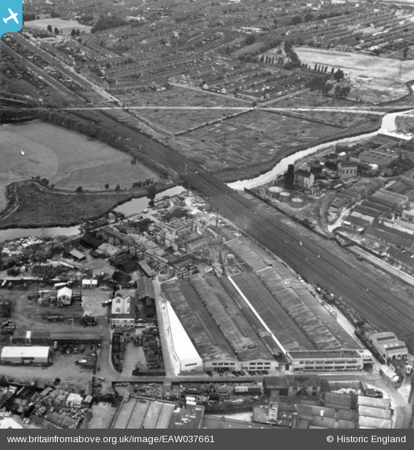
EAW037661 ENGLAND (1951). The Thames Plywood Manufactory Ltd Works, Barking, 1951. This image has been produced from a print marked by Aerofilms Ltd for photo editing.
© Copyright OpenStreetMap contributors and licensed by the OpenStreetMap Foundation. 2025. Cartography is licensed as CC BY-SA.
Nearby Images (23)
Details
| Title | [EAW037661] The Thames Plywood Manufactory Ltd Works, Barking, 1951. This image has been produced from a print marked by Aerofilms Ltd for photo editing. |
| Reference | EAW037661 |
| Date | 9-July-1951 |
| Link | |
| Place name | BARKING |
| Parish | |
| District | |
| Country | ENGLAND |
| Easting / Northing | 543620, 184742 |
| Longitude / Latitude | 0.0713135278563, 51.542797158954 |
| National Grid Reference | TQ436847 |
Pins
Be the first to add a comment to this image!


![[EAW037661] The Thames Plywood Manufactory Ltd Works, Barking, 1951. This image has been produced from a print marked by Aerofilms Ltd for photo editing.](http://britainfromabove.org.uk/sites/all/libraries/aerofilms-images/public/100x100/EAW/037/EAW037661.jpg)
![[EAW037659] The Thames Plywood Manufactory Ltd Works, Barking, 1951. This image has been produced from a print marked by Aerofilms Ltd for photo editing.](http://britainfromabove.org.uk/sites/all/libraries/aerofilms-images/public/100x100/EAW/037/EAW037659.jpg)
![[EAW037663] The Thames Plywood Manufactory Ltd Works, Barking, 1951. This image has been produced from a print marked by Aerofilms Ltd for photo editing.](http://britainfromabove.org.uk/sites/all/libraries/aerofilms-images/public/100x100/EAW/037/EAW037663.jpg)
![[EAW037657] The Thames Plywood Manufactory Ltd Works, Barking, 1951. This image has been produced from a print marked by Aerofilms Ltd for photo editing.](http://britainfromabove.org.uk/sites/all/libraries/aerofilms-images/public/100x100/EAW/037/EAW037657.jpg)
![[EAW037658] The Thames Plywood Manufactory Ltd Works, Barking, 1951. This image has been produced from a print marked by Aerofilms Ltd for photo editing.](http://britainfromabove.org.uk/sites/all/libraries/aerofilms-images/public/100x100/EAW/037/EAW037658.jpg)
![[EAW037660] The Thames Plywood Manufactory Ltd Works, Barking, 1951. This image has been produced from a print marked by Aerofilms Ltd for photo editing.](http://britainfromabove.org.uk/sites/all/libraries/aerofilms-images/public/100x100/EAW/037/EAW037660.jpg)
![[EAW037662] The Thames Plywood Manufactory Ltd Works, Barking, 1951. This image has been produced from a print marked by Aerofilms Ltd for photo editing.](http://britainfromabove.org.uk/sites/all/libraries/aerofilms-images/public/100x100/EAW/037/EAW037662.jpg)
![[EAW037664] The Thames Plywood Manufactory Ltd Works, Barking, 1951. This image has been produced from a print marked by Aerofilms Ltd for photo editing.](http://britainfromabove.org.uk/sites/all/libraries/aerofilms-images/public/100x100/EAW/037/EAW037664.jpg)
![[EAW037665] The Thames Plywood Manufactory Ltd Works, Barking, 1951. This image has been produced from a print marked by Aerofilms Ltd for photo editing.](http://britainfromabove.org.uk/sites/all/libraries/aerofilms-images/public/100x100/EAW/037/EAW037665.jpg)
![[EPW046634] Howards and Sons Ltd Uphall Chemical Works, Loxford, 1935](http://britainfromabove.org.uk/sites/all/libraries/aerofilms-images/public/100x100/EPW/046/EPW046634.jpg)
![[EAW005298] The River Roding, Howards and Sons Uphall Chemical Works and adjacent residential streets, Loxford, 1947](http://britainfromabove.org.uk/sites/all/libraries/aerofilms-images/public/100x100/EAW/005/EAW005298.jpg)
![[EPW046631] Howards and Sons Ltd Uphall Chemical Works, Loxford, 1935](http://britainfromabove.org.uk/sites/all/libraries/aerofilms-images/public/100x100/EPW/046/EPW046631.jpg)
![[EPW046637] Howards and Sons Ltd Uphall Chemical Works and environs, Loxford, 1935](http://britainfromabove.org.uk/sites/all/libraries/aerofilms-images/public/100x100/EPW/046/EPW046637.jpg)
![[EPW046635] Howards and Sons Ltd Uphall Chemical Works, Loxford, 1935](http://britainfromabove.org.uk/sites/all/libraries/aerofilms-images/public/100x100/EPW/046/EPW046635.jpg)
![[EPW046638] Howards and Sons Ltd Uphall Chemical Works and environs, Loxford, 1935](http://britainfromabove.org.uk/sites/all/libraries/aerofilms-images/public/100x100/EPW/046/EPW046638.jpg)
![[EPW046632] Howards and Sons Ltd Uphall Chemical Works, Loxford, 1935](http://britainfromabove.org.uk/sites/all/libraries/aerofilms-images/public/100x100/EPW/046/EPW046632.jpg)
![[EAW005297] The River Roding, Howards and Sons Uphall Chemical Works and adjacent residential streets, Loxford, 1947](http://britainfromabove.org.uk/sites/all/libraries/aerofilms-images/public/100x100/EAW/005/EAW005297.jpg)
![[EPW046636] Howards and Sons Ltd Uphall Chemical Works, Loxford, 1935](http://britainfromabove.org.uk/sites/all/libraries/aerofilms-images/public/100x100/EPW/046/EPW046636.jpg)
![[EPW060645] The Cape Asbestos Co Ltd Asbestos Works, Barking, 1939](http://britainfromabove.org.uk/sites/all/libraries/aerofilms-images/public/100x100/EPW/060/EPW060645.jpg)
![[EPW060644] The Cape Asbestos Co Ltd Asbestos Works, Barking, 1939](http://britainfromabove.org.uk/sites/all/libraries/aerofilms-images/public/100x100/EPW/060/EPW060644.jpg)
![[EPW060649] The Cape Asbestos Co Ltd Asbestos Works, Barking, 1939](http://britainfromabove.org.uk/sites/all/libraries/aerofilms-images/public/100x100/EPW/060/EPW060649.jpg)
![[EPW060651] The Cape Asbestos Co Ltd Asbestos Works, Barking, 1939](http://britainfromabove.org.uk/sites/all/libraries/aerofilms-images/public/100x100/EPW/060/EPW060651.jpg)
![[EPW060650] The Cape Asbestos Co Ltd Asbestos Works, Barking, 1939](http://britainfromabove.org.uk/sites/all/libraries/aerofilms-images/public/100x100/EPW/060/EPW060650.jpg)