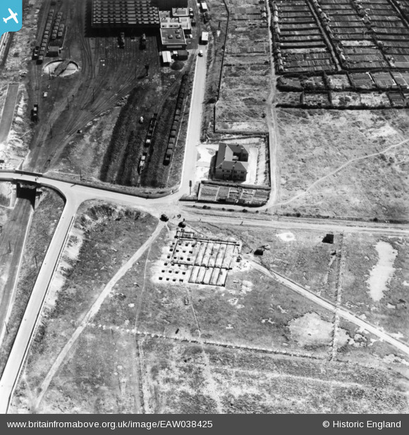
EAW038425 ENGLAND (1951). Tool Works under construction near Kettle Bridge, Sheffield, 1951. This image has been produced from a print.
© Copyright OpenStreetMap contributors and licensed by the OpenStreetMap Foundation. 2025. Cartography is licensed as CC BY-SA.
Nearby Images (15)
Details
| Title | [EAW038425] Tool Works under construction near Kettle Bridge, Sheffield, 1951. This image has been produced from a print. |
| Reference | EAW038425 |
| Date | 2-August-1951 |
| Link | |
| Place name | SHEFFIELD |
| Parish | |
| District | |
| Country | ENGLAND |
| Easting / Northing | 438333, 387773 |
| Longitude / Latitude | -1.4236064947673, 53.385145447482 |
| National Grid Reference | SK383878 |
Pins
 boltie |
Monday 20th of July 2015 08:46:15 PM |


![[EAW038425] Tool Works under construction near Kettle Bridge, Sheffield, 1951. This image has been produced from a print.](http://britainfromabove.org.uk/sites/all/libraries/aerofilms-images/public/100x100/EAW/038/EAW038425.jpg)
![[EAW038427] Tool Works under construction near Kettle Bridge, Sheffield, 1951. This image has been produced from a print marked by Aerofilms Ltd for photo editing.](http://britainfromabove.org.uk/sites/all/libraries/aerofilms-images/public/100x100/EAW/038/EAW038427.jpg)
![[EAW038424] Tool Works under construction near Kettle Bridge, Sheffield, 1951. This image has been produced from a print marked by Aerofilms Ltd for photo editing.](http://britainfromabove.org.uk/sites/all/libraries/aerofilms-images/public/100x100/EAW/038/EAW038424.jpg)
![[EAW038426] Tool Works under construction near Kettle Bridge, Sheffield, 1951. This image has been produced from a print marked by Aerofilms Ltd for photo editing.](http://britainfromabove.org.uk/sites/all/libraries/aerofilms-images/public/100x100/EAW/038/EAW038426.jpg)
![[EAW038419] The C & J Hampton Ltd Record Tool Works in Attercliffe, Sheffield, 1951. This image has been produced from a print marked by Aerofilms Ltd for photo editing.](http://britainfromabove.org.uk/sites/all/libraries/aerofilms-images/public/100x100/EAW/038/EAW038419.jpg)
![[EAW038421] The C & J Hampton Ltd Record Tool Works in Attercliffe, Sheffield, 1951. This image has been produced from a print marked by Aerofilms Ltd for photo editing.](http://britainfromabove.org.uk/sites/all/libraries/aerofilms-images/public/100x100/EAW/038/EAW038421.jpg)
![[EPW055179] C. and J. Hampton Ltd Record Tool Works in Attercliffe, Sheffield, 1937](http://britainfromabove.org.uk/sites/all/libraries/aerofilms-images/public/100x100/EPW/055/EPW055179.jpg)
![[EPW055178] C. and J. Hampton Ltd Record Tool Works in Attercliffe, Sheffield, 1937](http://britainfromabove.org.uk/sites/all/libraries/aerofilms-images/public/100x100/EPW/055/EPW055178.jpg)
![[EAW038422] Ouseburn Road and the C & J Hampton Ltd Record Tool Works in Attercliffe, Sheffield, 1951. This image has been produced from a print marked by Aerofilms Ltd for photo editing.](http://britainfromabove.org.uk/sites/all/libraries/aerofilms-images/public/100x100/EAW/038/EAW038422.jpg)
![[EPW055182] C. and J. Hampton Ltd Record Tool Works in Attercliffe, Sheffield, 1937](http://britainfromabove.org.uk/sites/all/libraries/aerofilms-images/public/100x100/EPW/055/EPW055182.jpg)
![[EPW055181] C. and J. Hampton Ltd Record Tool Works in Attercliffe, Sheffield, 1937](http://britainfromabove.org.uk/sites/all/libraries/aerofilms-images/public/100x100/EPW/055/EPW055181.jpg)
![[EAW038418] The C & J Hampton Ltd Record Tool Works in Attercliffe, Sheffield, 1951. This image has been produced from a print marked by Aerofilms Ltd for photo editing.](http://britainfromabove.org.uk/sites/all/libraries/aerofilms-images/public/100x100/EAW/038/EAW038418.jpg)
![[EAW038423] The C & J Hampton Ltd Record Tool Works in Attercliffe, Sheffield, 1951. This image has been produced from a print marked by Aerofilms Ltd for photo editing.](http://britainfromabove.org.uk/sites/all/libraries/aerofilms-images/public/100x100/EAW/038/EAW038423.jpg)
![[EAW038420] The C & J Hampton Ltd Record Tool Works in Attercliffe, Sheffield, 1951. This image has been produced from a print marked by Aerofilms Ltd for photo editing.](http://britainfromabove.org.uk/sites/all/libraries/aerofilms-images/public/100x100/EAW/038/EAW038420.jpg)
![[EPW055183] C. and J. Hampton Ltd Record Tool Works in Attercliffe, Sheffield, 1937](http://britainfromabove.org.uk/sites/all/libraries/aerofilms-images/public/100x100/EPW/055/EPW055183.jpg)
