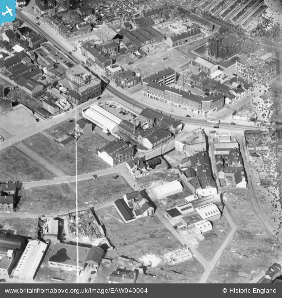
EAW040064 ENGLAND (1951). Industrial works surrounding Allen Street and Smithfield, Sheffield, 1951. This image has been produced from a damaged negative.
© Copyright OpenStreetMap contributors and licensed by the OpenStreetMap Foundation. 2025. Cartography is licensed as CC BY-SA.
Nearby Images (6)
Details
| Title | [EAW040064] Industrial works surrounding Allen Street and Smithfield, Sheffield, 1951. This image has been produced from a damaged negative. |
| Reference | EAW040064 |
| Date | 17-September-1951 |
| Link | |
| Place name | SHEFFIELD |
| Parish | |
| District | |
| Country | ENGLAND |
| Easting / Northing | 435019, 387932 |
| Longitude / Latitude | -1.4734173456556, 53.386804897952 |
| National Grid Reference | SK350879 |
Pins
Be the first to add a comment to this image!


![[EAW040064] Industrial works surrounding Allen Street and Smithfield, Sheffield, 1951. This image has been produced from a damaged negative.](http://britainfromabove.org.uk/sites/all/libraries/aerofilms-images/public/100x100/EAW/040/EAW040064.jpg)
![[EAW040063] Industrial works surrounding Gibraltar Street and Smithfield, Sheffield, 1951. This image has been produced from a damaged negative.](http://britainfromabove.org.uk/sites/all/libraries/aerofilms-images/public/100x100/EAW/040/EAW040063.jpg)
![[EAW040061] Industrial works surrounding Allen Street and Smithfield, Sheffield, 1951. This image was marked by Aerofilms Ltd for photo editing.](http://britainfromabove.org.uk/sites/all/libraries/aerofilms-images/public/100x100/EAW/040/EAW040061.jpg)
![[EAW040062] Industrial works surrounding Gibraltar Street and Smithfield, Sheffield, 1951. This image has been produced from a damaged negative.](http://britainfromabove.org.uk/sites/all/libraries/aerofilms-images/public/100x100/EAW/040/EAW040062.jpg)
![[EAW038430] The W. A. Tyzack & Co Ltd Horseman Works and environs, Sheffield, 1951. This image has been produced from a print marked by Aerofilms Ltd for photo editing.](http://britainfromabove.org.uk/sites/all/libraries/aerofilms-images/public/100x100/EAW/038/EAW038430.jpg)
![[EAW038432] The W. A. Tyzack & Co Ltd Horseman Works, Kelham Island and environs, Sheffield, 1951. This image has been produced from a print marked by Aerofilms Ltd for photo editing.](http://britainfromabove.org.uk/sites/all/libraries/aerofilms-images/public/100x100/EAW/038/EAW038432.jpg)