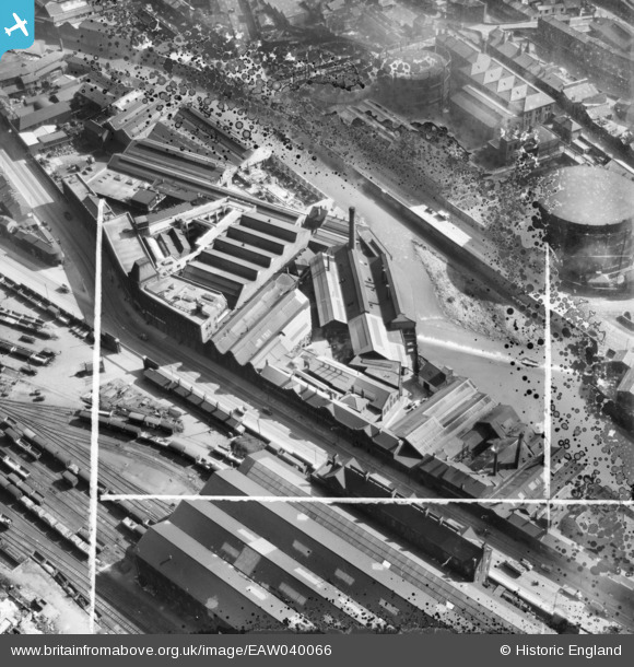
EAW040066 ENGLAND (1951). The Don Steel Works and environs, Sheffield, 1951. This image has been produced from a damaged negative.
© Copyright OpenStreetMap contributors and licensed by the OpenStreetMap Foundation. 2025. Cartography is licensed as CC BY-SA.
Nearby Images (11)
Details
| Title | [EAW040066] The Don Steel Works and environs, Sheffield, 1951. This image has been produced from a damaged negative. |
| Reference | EAW040066 |
| Date | 17-September-1951 |
| Link | |
| Place name | SHEFFIELD |
| Parish | |
| District | |
| Country | ENGLAND |
| Easting / Northing | 436251, 388166 |
| Longitude / Latitude | -1.4548657250257, 53.38882523723 |
| National Grid Reference | SK363882 |


![[EAW040066] The Don Steel Works and environs, Sheffield, 1951. This image has been produced from a damaged negative.](http://britainfromabove.org.uk/sites/all/libraries/aerofilms-images/public/100x100/EAW/040/EAW040066.jpg)
![[EAW040065] The Don Steel Works and environs, Sheffield, 1951. This image has been produced from a damaged negative.](http://britainfromabove.org.uk/sites/all/libraries/aerofilms-images/public/100x100/EAW/040/EAW040065.jpg)
![[EPW015497] The Effingham Street Gas Works, Sheffield, 1926](http://britainfromabove.org.uk/sites/all/libraries/aerofilms-images/public/100x100/EPW/015/EPW015497.jpg)
![[EPW015498] The Effingham Street Gas Works, Sheffield, 1926](http://britainfromabove.org.uk/sites/all/libraries/aerofilms-images/public/100x100/EPW/015/EPW015498.jpg)
![[EPW015499] The Effingham Street Gas Works, Sheffield, 1926](http://britainfromabove.org.uk/sites/all/libraries/aerofilms-images/public/100x100/EPW/015/EPW015499.jpg)
![[EAW014672] The B & J Sippel Ltd Sipelia Cutlery Works and the Sheffield Gas Co Gas Works, Sheffield, 1948](http://britainfromabove.org.uk/sites/all/libraries/aerofilms-images/public/100x100/EAW/014/EAW014672.jpg)
![[EAW014666] The B & J Sippel Ltd Sipelia Cutlery Works, Sheffield, 1948. This image was marked by Aerofilms Ltd for photo editing.](http://britainfromabove.org.uk/sites/all/libraries/aerofilms-images/public/100x100/EAW/014/EAW014666.jpg)
![[EAW014668] The B & J Sippel Ltd Sipelia Cutlery Works, Sheffield, 1948. This image was marked by Aerofilms Ltd for photo editing.](http://britainfromabove.org.uk/sites/all/libraries/aerofilms-images/public/100x100/EAW/014/EAW014668.jpg)
![[EAW014670] The B & J Sippel Ltd Sipelia Cutlery Works, Sheffield, 1948](http://britainfromabove.org.uk/sites/all/libraries/aerofilms-images/public/100x100/EAW/014/EAW014670.jpg)
![[EAW014667] The B & J Sippel Ltd Sipelia Cutlery Works, Sheffield, 1948. This image was marked by Aerofilms Ltd for photo editing.](http://britainfromabove.org.uk/sites/all/libraries/aerofilms-images/public/100x100/EAW/014/EAW014667.jpg)
![[EAW017299] The Cyclops Steel and Iron Works off Carlisle Street and surrounding industrial area, Burngreave, 1948. This image has been produced from a print marked by Aerofilms Ltd for photo editing.](http://britainfromabove.org.uk/sites/all/libraries/aerofilms-images/public/100x100/EAW/017/EAW017299.jpg)
