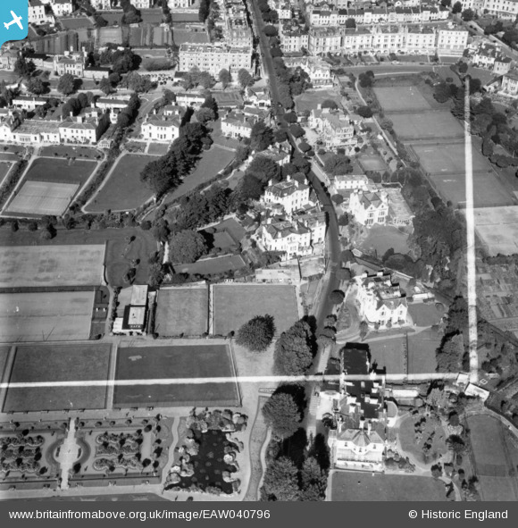
EAW040796 ENGLAND (1951). Hotels along Belgrave Road, Torbay, 1951. This image has been produced from a print marked by Aerofilms Ltd for photo editing.
© Copyright OpenStreetMap contributors and licensed by the OpenStreetMap Foundation. 2025. Cartography is licensed as CC BY-SA.
Nearby Images (21)
Details
| Title | [EAW040796] Hotels along Belgrave Road, Torbay, 1951. This image has been produced from a print marked by Aerofilms Ltd for photo editing. |
| Reference | EAW040796 |
| Date | 12-October-1951 |
| Link | |
| Place name | TORBAY |
| Parish | |
| District | |
| Country | ENGLAND |
| Easting / Northing | 291014, 63860 |
| Longitude / Latitude | -3.5357318264185, 50.463826548676 |
| National Grid Reference | SX910639 |
Pins
Be the first to add a comment to this image!


![[EAW040796] Hotels along Belgrave Road, Torbay, 1951. This image has been produced from a print marked by Aerofilms Ltd for photo editing.](http://britainfromabove.org.uk/sites/all/libraries/aerofilms-images/public/100x100/EAW/040/EAW040796.jpg)
![[EAW047130] Belgrave Road and Abbey Park, Torquay, 1952. This image was marked by Aerofilms Ltd for photo editing.](http://britainfromabove.org.uk/sites/all/libraries/aerofilms-images/public/100x100/EAW/047/EAW047130.jpg)
![[EAW040797] Hotels along Belgrave Road and Abbey Park, Torbay, 1951. This image has been produced from a print marked by Aerofilms Ltd for photo editing.](http://britainfromabove.org.uk/sites/all/libraries/aerofilms-images/public/100x100/EAW/040/EAW040797.jpg)
![[EAW040800] The Roslin Hall Hotel, Torbay, 1951. This image has been produced from a print marked by Aerofilms Ltd for photo editing.](http://britainfromabove.org.uk/sites/all/libraries/aerofilms-images/public/100x100/EAW/040/EAW040800.jpg)
![[EAW040798] The Roslin Hall Hotel alongside Abbey Park, Torbay, 1951. This image has been produced from a print marked by Aerofilms Ltd for photo editing.](http://britainfromabove.org.uk/sites/all/libraries/aerofilms-images/public/100x100/EAW/040/EAW040798.jpg)
![[EAW040801] The Roslin Hall Hotel and Abbey Park, Torbay, 1951. This image has been produced from a print marked by Aerofilms Ltd for photo editing.](http://britainfromabove.org.uk/sites/all/libraries/aerofilms-images/public/100x100/EAW/040/EAW040801.jpg)
![[EAW040795] Hotels along Belgrave Road, Abbey Park and the seafront, Torbay, 1951. This image has been produced from a print marked by Aerofilms Ltd for photo editing.](http://britainfromabove.org.uk/sites/all/libraries/aerofilms-images/public/100x100/EAW/040/EAW040795.jpg)
![[EAW040791] The San Remo, Sherwood and Roslin Hall Hotels along Belgrave Road, Torbay, 1951. This image has been produced from a print marked by Aerofilms Ltd for photo editing.](http://britainfromabove.org.uk/sites/all/libraries/aerofilms-images/public/100x100/EAW/040/EAW040791.jpg)
![[EAW047131] Belgrave Road and Abbey Park, Torquay, 1952. This image was marked by Aerofilms Ltd for photo editing.](http://britainfromabove.org.uk/sites/all/libraries/aerofilms-images/public/100x100/EAW/047/EAW047131.jpg)
![[EAW040794] Hotels along Belgrave Road, Abbey Park and the seafront, Torbay, 1951. This image has been produced from a print marked by Aerofilms Ltd for photo editing.](http://britainfromabove.org.uk/sites/all/libraries/aerofilms-images/public/100x100/EAW/040/EAW040794.jpg)
![[EAW047127] Belgrave Road, Abbey Park and the sea front, Torquay, 1952. This image was marked by Aerofilms Ltd for photo editing.](http://britainfromabove.org.uk/sites/all/libraries/aerofilms-images/public/100x100/EAW/047/EAW047127.jpg)
![[EAW040799] The Roslin Hall Hotel, Abbey Park and the seafront, Torbay, 1951. This image has been produced from a print marked by Aerofilms Ltd for photo editing.](http://britainfromabove.org.uk/sites/all/libraries/aerofilms-images/public/100x100/EAW/040/EAW040799.jpg)
![[EAW047129] Belgrave Road, Abbey Park and the sea front, Torquay, 1952. This image was marked by Aerofilms Ltd for photo editing.](http://britainfromabove.org.uk/sites/all/libraries/aerofilms-images/public/100x100/EAW/047/EAW047129.jpg)
![[EAW047126] Belgrave Road, Abbey Park and the sea front, Torquay, 1952. This image was marked by Aerofilms Ltd for photo editing.](http://britainfromabove.org.uk/sites/all/libraries/aerofilms-images/public/100x100/EAW/047/EAW047126.jpg)
![[EAW040792] Abbey Park and the surrounding area, Torbay, 1951. This image has been produced from a print marked by Aerofilms Ltd for photo editing.](http://britainfromabove.org.uk/sites/all/libraries/aerofilms-images/public/100x100/EAW/040/EAW040792.jpg)
![[EAW047132] Belgrave Road and Abbey Park, Torquay, 1952. This image was marked by Aerofilms Ltd for photo editing.](http://britainfromabove.org.uk/sites/all/libraries/aerofilms-images/public/100x100/EAW/047/EAW047132.jpg)
![[EAW040793] Abbey Park and the surrounding area, Torbay, 1951. This image has been produced from a print marked by Aerofilms Ltd for photo editing.](http://britainfromabove.org.uk/sites/all/libraries/aerofilms-images/public/100x100/EAW/040/EAW040793.jpg)
![[EAW047128] Belgrave Road, Abbey Park and the sea front, Torquay, 1952. This image was marked by Aerofilms Ltd for photo editing.](http://britainfromabove.org.uk/sites/all/libraries/aerofilms-images/public/100x100/EAW/047/EAW047128.jpg)
![[EPW023723] Torbay Road and Tor Abbey Sands, Torquay, 1928](http://britainfromabove.org.uk/sites/all/libraries/aerofilms-images/public/100x100/EPW/023/EPW023723.jpg)
![[EAW011694] Abbey Park and Torre Abbey Sands, Torquay, 1947](http://britainfromabove.org.uk/sites/all/libraries/aerofilms-images/public/100x100/EAW/011/EAW011694.jpg)
![[EAW011695] Torre Abbey Sands, Torquay, 1947](http://britainfromabove.org.uk/sites/all/libraries/aerofilms-images/public/100x100/EAW/011/EAW011695.jpg)