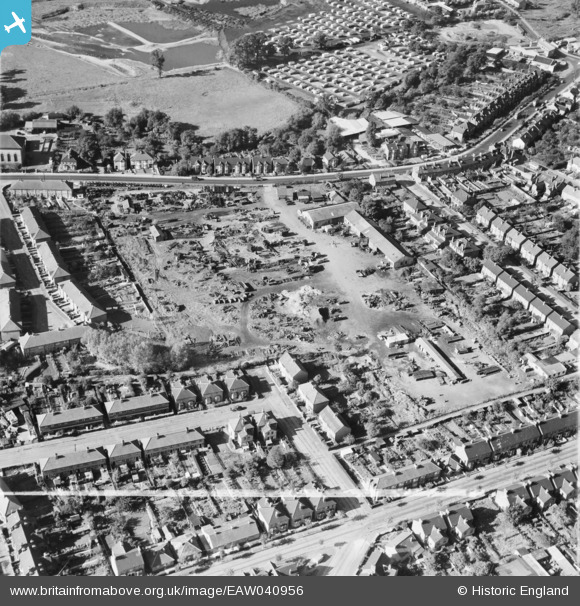
EAW040956 ENGLAND (1951). The site of the Brooke Trading Estate, Romford, 1951. This image was marked by Aerofilms Ltd for photo editing.
© Copyright OpenStreetMap contributors and licensed by the OpenStreetMap Foundation. 2025. Cartography is licensed as CC BY-SA.
Nearby Images (12)
Details
| Title | [EAW040956] The site of the Brooke Trading Estate, Romford, 1951. This image was marked by Aerofilms Ltd for photo editing. |
| Reference | EAW040956 |
| Date | 17-October-1951 |
| Link | |
| Place name | ROMFORD |
| Parish | |
| District | |
| Country | ENGLAND |
| Easting / Northing | 551776, 187870 |
| Longitude / Latitude | 0.19020111025381, 51.568770260503 |
| National Grid Reference | TQ518879 |
Pins
 Tommy |
Saturday 25th of February 2017 09:25:41 AM | |
 Tommy |
Saturday 25th of February 2017 09:24:50 AM | |
 GeoffR |
Friday 16th of January 2015 05:55:18 PM | |
 GeoffR |
Friday 16th of January 2015 05:52:34 PM |
User Comment Contributions
I have attached an aerial view of this area in 2016 |
 Tommy |
Saturday 25th of February 2017 09:36:52 AM |


![[EAW040956] The site of the Brooke Trading Estate, Romford, 1951. This image was marked by Aerofilms Ltd for photo editing.](http://britainfromabove.org.uk/sites/all/libraries/aerofilms-images/public/100x100/EAW/040/EAW040956.jpg)
![[EAW040958] The site of the Brooke Trading Estate, Romford, 1951. This image was marked by Aerofilms Ltd for photo editing.](http://britainfromabove.org.uk/sites/all/libraries/aerofilms-images/public/100x100/EAW/040/EAW040958.jpg)
![[EAW040953] The site of the Brooke Trading Estate, Romford, 1951. This image was marked by Aerofilms Ltd for photo editing.](http://britainfromabove.org.uk/sites/all/libraries/aerofilms-images/public/100x100/EAW/040/EAW040953.jpg)
![[EAW040955] The site of the Brooke Trading Estate, Romford, 1951. This image was marked by Aerofilms Ltd for photo editing.](http://britainfromabove.org.uk/sites/all/libraries/aerofilms-images/public/100x100/EAW/040/EAW040955.jpg)
![[EAW040959] The site of the Brooke Trading Estate, Romford, 1951. This image was marked by Aerofilms Ltd for photo editing.](http://britainfromabove.org.uk/sites/all/libraries/aerofilms-images/public/100x100/EAW/040/EAW040959.jpg)
![[EAW040957] The site of the Brooke Trading Estate, Romford, 1951. This image was marked by Aerofilms Ltd for photo editing.](http://britainfromabove.org.uk/sites/all/libraries/aerofilms-images/public/100x100/EAW/040/EAW040957.jpg)
![[EAW040954] The site of the Brooke Trading Estate, Romford, 1951. This image was marked by Aerofilms Ltd for photo editing.](http://britainfromabove.org.uk/sites/all/libraries/aerofilms-images/public/100x100/EAW/040/EAW040954.jpg)
![[EAW040960] The site of the Brooke Trading Estate, Romford, 1951. This image was marked by Aerofilms Ltd for photo editing.](http://britainfromabove.org.uk/sites/all/libraries/aerofilms-images/public/100x100/EAW/040/EAW040960.jpg)
![[EAW013348] The Roneo Works and environs, Romford, 1948. This image has been produced from a print.](http://britainfromabove.org.uk/sites/all/libraries/aerofilms-images/public/100x100/EAW/013/EAW013348.jpg)
![[EAW013350] The Roneo Works, Romford, 1948. This image has been produced from a damaged negative.](http://britainfromabove.org.uk/sites/all/libraries/aerofilms-images/public/100x100/EAW/013/EAW013350.jpg)
![[EAW013354] The Roneo Works, Romford, 1948. This image was marked by Aerofilms Ltd for photo editing.](http://britainfromabove.org.uk/sites/all/libraries/aerofilms-images/public/100x100/EAW/013/EAW013354.jpg)
![[EAW013351] The Roneo Works, Romford, 1948. This image has been produced from a damaged negative.](http://britainfromabove.org.uk/sites/all/libraries/aerofilms-images/public/100x100/EAW/013/EAW013351.jpg)