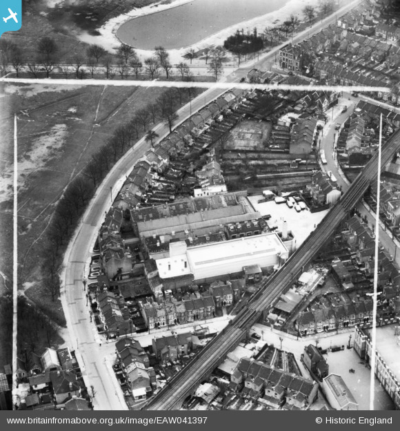
EAW041397 ENGLAND (1951). The H. W. Nevill Ltd Bakery off Harrow Road, Leytonstone, 1951. This image has been produced from a print marked by Aerofilms Ltd for photo editing.
© Copyright OpenStreetMap contributors and licensed by the OpenStreetMap Foundation. 2025. Cartography is licensed as CC BY-SA.
Nearby Images (12)
Details
| Title | [EAW041397] The H. W. Nevill Ltd Bakery off Harrow Road, Leytonstone, 1951. This image has been produced from a print marked by Aerofilms Ltd for photo editing. |
| Reference | EAW041397 |
| Date | 22-November-1951 |
| Link | |
| Place name | LEYTONSTONE |
| Parish | |
| District | |
| Country | ENGLAND |
| Easting / Northing | 539849, 186347 |
| Longitude / Latitude | 0.017602453119022, 51.558168239152 |
| National Grid Reference | TQ398863 |
Pins
Be the first to add a comment to this image!


![[EAW041397] The H. W. Nevill Ltd Bakery off Harrow Road, Leytonstone, 1951. This image has been produced from a print marked by Aerofilms Ltd for photo editing.](http://britainfromabove.org.uk/sites/all/libraries/aerofilms-images/public/100x100/EAW/041/EAW041397.jpg)
![[EAW041398] The H. W. Nevill Ltd Bakery off Harrow Road, Leytonstone, 1951. This image has been produced from a print marked by Aerofilms Ltd for photo editing.](http://britainfromabove.org.uk/sites/all/libraries/aerofilms-images/public/100x100/EAW/041/EAW041398.jpg)
![[EAW041395] The H. W. Nevill Ltd Bakery off Harrow Road and adjacent railway viaduct, Leytonstone, 1951. This image has been produced from a print marked by Aerofilms Ltd for photo editing.](http://britainfromabove.org.uk/sites/all/libraries/aerofilms-images/public/100x100/EAW/041/EAW041395.jpg)
![[EAW041399] The H. W. Nevill Ltd Bakery off Harrow Road, Leytonstone, 1951. This image has been produced from a print marked by Aerofilms Ltd for photo editing.](http://britainfromabove.org.uk/sites/all/libraries/aerofilms-images/public/100x100/EAW/041/EAW041399.jpg)
![[EAW041400] The H. W. Nevill Ltd Bakery off Harrow Road, Leytonstone, 1951. This image was marked by Aerofilms Ltd for photo editing.](http://britainfromabove.org.uk/sites/all/libraries/aerofilms-images/public/100x100/EAW/041/EAW041400.jpg)
![[EAW041402] The H. W. Nevill Ltd Bakery off Harrow Road and adjacent railway viaduct, Leytonstone, 1951. This image has been produced from a print marked by Aerofilms Ltd for photo editing.](http://britainfromabove.org.uk/sites/all/libraries/aerofilms-images/public/100x100/EAW/041/EAW041402.jpg)
![[EAW041394] The H. W. Nevill Ltd Bakery off Harrow Road and adjacent railway viaduct, Leytonstone, 1951. This image has been produced from a print marked by Aerofilms Ltd for photo editing.](http://britainfromabove.org.uk/sites/all/libraries/aerofilms-images/public/100x100/EAW/041/EAW041394.jpg)
![[EAW041403] The H. W. Nevill Ltd Bakery off Harrow Road and adjacent railway viaduct, Leytonstone, 1951. This image has been produced from a print marked by Aerofilms Ltd for photo editing.](http://britainfromabove.org.uk/sites/all/libraries/aerofilms-images/public/100x100/EAW/041/EAW041403.jpg)
![[EAW041396] The H. W. Nevill Ltd Bakery off Harrow Road, Leytonstone, 1951. This image has been produced from a print marked by Aerofilms Ltd for photo editing.](http://britainfromabove.org.uk/sites/all/libraries/aerofilms-images/public/100x100/EAW/041/EAW041396.jpg)
![[EAW041401] The H. W. Nevill Ltd Bakery (site of) off Harrow Road, Leytonstone, 1951. This image has been produced from a damaged negative.](http://britainfromabove.org.uk/sites/all/libraries/aerofilms-images/public/100x100/EAW/041/EAW041401.jpg)
![[EAW041405] The H. W. Nevill Ltd Bakery off Harrow Road and adjacent railway viaduct, Leytonstone, 1951. This image has been produced from a print marked by Aerofilms Ltd for photo editing.](http://britainfromabove.org.uk/sites/all/libraries/aerofilms-images/public/100x100/EAW/041/EAW041405.jpg)
![[EAW041404] Cobbold Road, the H. W. Nevill Ltd Bakery off Harrow Road and adjacent railway viaduct, Leytonstone, 1951. This image has been produced from a print marked by Aerofilms Ltd for photo editing.](http://britainfromabove.org.uk/sites/all/libraries/aerofilms-images/public/100x100/EAW/041/EAW041404.jpg)