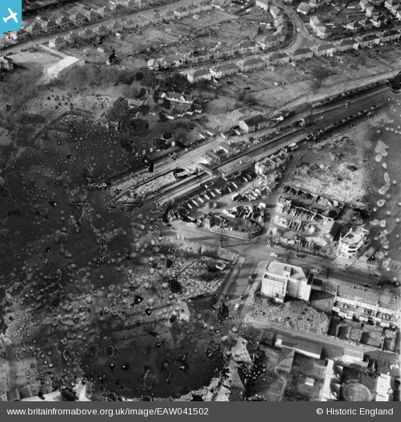
EAW041502 ENGLAND (1952). Potters Bar and South Mimms Railway Station, Potters Bar, 1952. This image has been produced from a damaged negative.
© Copyright OpenStreetMap contributors and licensed by the OpenStreetMap Foundation. 2025. Cartography is licensed as CC BY-SA.
Nearby Images (5)
Details
| Title | [EAW041502] Potters Bar and South Mimms Railway Station, Potters Bar, 1952. This image has been produced from a damaged negative. |
| Reference | EAW041502 |
| Date | 3-January-1952 |
| Link | |
| Place name | POTTERS BAR |
| Parish | |
| District | |
| Country | ENGLAND |
| Easting / Northing | 525016, 201363 |
| Longitude / Latitude | -0.19091040500305, 51.696612892502 |
| National Grid Reference | TL250014 |
Pins
 pber |
Monday 16th of March 2015 08:15:08 PM | |
 Ray Flack |
Tuesday 29th of July 2014 02:54:47 PM | |
 Ray Flack |
Tuesday 29th of July 2014 02:53:32 PM | |
 Ray Flack |
Tuesday 29th of July 2014 02:52:55 PM | |
 Ray Flack |
Tuesday 29th of July 2014 02:52:32 PM |
User Comment Contributions
By 1955 the station had been completely rebuilt as part of the widening of this part of the East Coast main line from two tracks to four. The rebuild included a new signal box containing a modern electrical operating panel rather than the traditional mechanical lever system. |
 John W |
Tuesday 6th of December 2016 05:18:37 PM |


![[EAW041502] Potters Bar and South Mimms Railway Station, Potters Bar, 1952. This image has been produced from a damaged negative.](http://britainfromabove.org.uk/sites/all/libraries/aerofilms-images/public/100x100/EAW/041/EAW041502.jpg)
![[EAW041501] Potters Bar and South Mimms Railway Station, Potters Bar, 1952](http://britainfromabove.org.uk/sites/all/libraries/aerofilms-images/public/100x100/EAW/041/EAW041501.jpg)
![[EAW041500] Potters Bar and South Mimms Railway Station, Potters Bar, 1952. This image has been produced from a damaged negative.](http://britainfromabove.org.uk/sites/all/libraries/aerofilms-images/public/100x100/EAW/041/EAW041500.jpg)
![[EAW043442] Darkes Lane and environs, Potters Bar, 1952. This image was marked by Aerofilms Ltd for photo editing.](http://britainfromabove.org.uk/sites/all/libraries/aerofilms-images/public/100x100/EAW/043/EAW043442.jpg)
![[EAW043443] Darkes Lane and environs, Potters Bar, 1952](http://britainfromabove.org.uk/sites/all/libraries/aerofilms-images/public/100x100/EAW/043/EAW043443.jpg)