
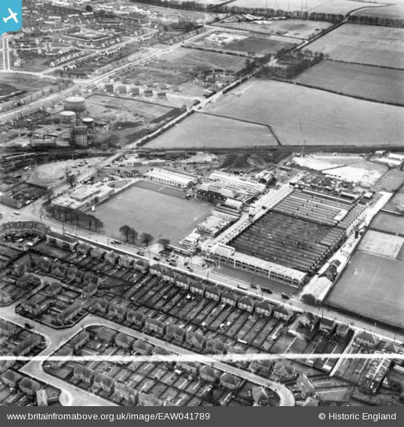
EAW041789 ENGLAND (1952). The AC-Sphinx Sparking Plug Co Ltd Works, Dunstable, 1952. This image has been produced from a print marked by Aerofilms Ltd for photo editing.
© Copyright OpenStreetMap contributors and licensed by the OpenStreetMap Foundation. 2025. Cartography is licensed as CC BY-SA.
Nearby Images (38)
EAW041789

EAW028373

EAW041805

EAW041790

EAW041795

EAW041794

EAW028377

EAW051389

EAW041788

EAW041792

EAW028379

EAW051392

EAW041793

EAW041791

EAW041796

EAW041801

EAW041803

EAW028384

EAW028378

EAW051386

EAW051388

EAW028382

EAW051390

EAW028376

EAW041798

EAW051387

EAW051391

EAW028380

EAW028374

EAW041806

EAW041800

EAW041797

EAW041804

EAW028381

EAW028375

EAW041799

EAW041802

EAW028383

Details
| Title | [EAW041789] The AC-Sphinx Sparking Plug Co Ltd Works, Dunstable, 1952. This image has been produced from a print marked by Aerofilms Ltd for photo editing. |
| Reference | EAW041789 |
| Date | 4-March-1952 |
| Link | |
| Place name | DUNSTABLE |
| Parish | DUNSTABLE |
| District | |
| Country | ENGLAND |
| Easting / Northing | 500905, 222770 |
| Longitude / Latitude | -0.53344998893624, 51.893896653444 |
| National Grid Reference | TL009228 |
Pins
 ordinarybloke |
Saturday 1st of November 2014 05:23:02 PM |