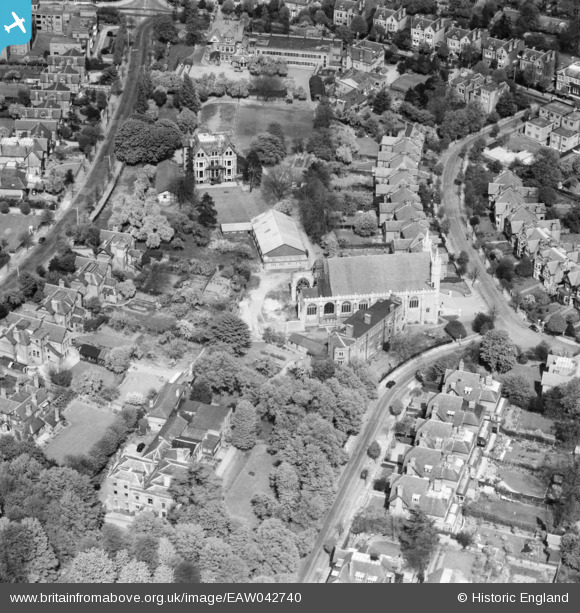
EAW042740 ENGLAND (1952). St Benedict's Church and School, Ealing, 1952
© Copyright OpenStreetMap contributors and licensed by the OpenStreetMap Foundation. 2025. Cartography is licensed as CC BY-SA.
Nearby Images (8)
Details
| Title | [EAW042740] St Benedict's Church and School, Ealing, 1952 |
| Reference | EAW042740 |
| Date | 29-April-1952 |
| Link | |
| Place name | EALING |
| Parish | |
| District | |
| Country | ENGLAND |
| Easting / Northing | 517422, 181465 |
| Longitude / Latitude | -0.30741440374516, 51.519402163527 |
| National Grid Reference | TQ174815 |
Pins
Be the first to add a comment to this image!


![[EAW042740] St Benedict's Church and School, Ealing, 1952](http://britainfromabove.org.uk/sites/all/libraries/aerofilms-images/public/100x100/EAW/042/EAW042740.jpg)
![[EAW042733] St Benedict's Church and School, Ealing, 1952. This image was marked by Aerofilms Ltd for photo editing.](http://britainfromabove.org.uk/sites/all/libraries/aerofilms-images/public/100x100/EAW/042/EAW042733.jpg)
![[EAW042736] St Benedict's Church and School and the surrounding residential area, Ealing, 1952. This image was marked by Aerofilms Ltd for photo editing.](http://britainfromabove.org.uk/sites/all/libraries/aerofilms-images/public/100x100/EAW/042/EAW042736.jpg)
![[EAW042735] St Benedict's Church and School and the surrounding residential area, Ealing, 1952. This image was marked by Aerofilms Ltd for photo editing.](http://britainfromabove.org.uk/sites/all/libraries/aerofilms-images/public/100x100/EAW/042/EAW042735.jpg)
![[EAW042734] St Benedict's Church and School and the surrounding residential area, Ealing, 1952. This image was marked by Aerofilms Ltd for photo editing.](http://britainfromabove.org.uk/sites/all/libraries/aerofilms-images/public/100x100/EAW/042/EAW042734.jpg)
![[EAW042737] St Benedict's Church and School and the surrounding residential area, Ealing, 1952. This image was marked by Aerofilms Ltd for photo editing.](http://britainfromabove.org.uk/sites/all/libraries/aerofilms-images/public/100x100/EAW/042/EAW042737.jpg)
![[EAW042738] St Benedict's Church and School and the surrounding residential area, Ealing, 1952. This image was marked by Aerofilms Ltd for photo editing.](http://britainfromabove.org.uk/sites/all/libraries/aerofilms-images/public/100x100/EAW/042/EAW042738.jpg)
![[EAW042739] St Benedict's Church and School, Ealing, 1952](http://britainfromabove.org.uk/sites/all/libraries/aerofilms-images/public/100x100/EAW/042/EAW042739.jpg)