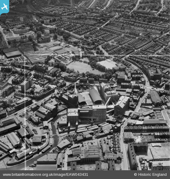
EAW043431 ENGLAND (1952). Flour Mills at Deptford Creek, Deptford, 1952. This image was marked by Aerofilms Ltd for photo editing.
© Copyright OpenStreetMap contributors and licensed by the OpenStreetMap Foundation. 2025. Cartography is licensed as CC BY-SA.
Nearby Images (18)
Details
| Title | [EAW043431] Flour Mills at Deptford Creek, Deptford, 1952. This image was marked by Aerofilms Ltd for photo editing. |
| Reference | EAW043431 |
| Date | 28-May-1952 |
| Link | |
| Place name | DEPTFORD |
| Parish | |
| District | |
| Country | ENGLAND |
| Easting / Northing | 537477, 177022 |
| Longitude / Latitude | -0.020234137354758, 51.474946746725 |
| National Grid Reference | TQ375770 |
Pins
 John W |
Saturday 7th of May 2016 04:21:02 PM | |
 John W |
Saturday 7th of May 2016 04:15:04 PM | |
 Peter Turvey |
Monday 24th of November 2014 06:01:35 PM | |
 47Bus |
Wednesday 15th of October 2014 06:44:53 PM | |
 Class31 |
Tuesday 5th of August 2014 11:17:59 PM | |
 Class31 |
Tuesday 5th of August 2014 11:15:22 PM | |
 Class31 |
Tuesday 5th of August 2014 11:13:44 PM | |
 Class31 |
Tuesday 5th of August 2014 11:10:29 PM | |
 Class31 |
Tuesday 5th of August 2014 11:08:39 PM | |
 Class31 |
Tuesday 5th of August 2014 11:08:01 PM |


![[EAW043431] Flour Mills at Deptford Creek, Deptford, 1952. This image was marked by Aerofilms Ltd for photo editing.](http://britainfromabove.org.uk/sites/all/libraries/aerofilms-images/public/100x100/EAW/043/EAW043431.jpg)
![[EAW043426] Flour Mills at Deptford Creek, Deptford, 1952. This image was marked by Aerofilms Ltd for photo editing.](http://britainfromabove.org.uk/sites/all/libraries/aerofilms-images/public/100x100/EAW/043/EAW043426.jpg)
![[EPW007528] The J. and H. Robinson Ltd Flour and Corn Mills, Deptford, 1921. This image has been produced from a print.](http://britainfromabove.org.uk/sites/all/libraries/aerofilms-images/public/100x100/EPW/007/EPW007528.jpg)
![[EAW043432] Flour Mills at Deptford Creek, Deptford, 1952. This image was marked by Aerofilms Ltd for photo editing.](http://britainfromabove.org.uk/sites/all/libraries/aerofilms-images/public/100x100/EAW/043/EAW043432.jpg)
![[EAW043425] Flour Mills at Deptford Creek, Deptford, 1952. This image was marked by Aerofilms Ltd for photo editing.](http://britainfromabove.org.uk/sites/all/libraries/aerofilms-images/public/100x100/EAW/043/EAW043425.jpg)
![[EAW043429] Flour Mills at Deptford Creek, Deptford, 1952. This image was marked by Aerofilms Ltd for photo editing.](http://britainfromabove.org.uk/sites/all/libraries/aerofilms-images/public/100x100/EAW/043/EAW043429.jpg)
![[EAW043427] Flour Mills at Deptford Creek, Deptford, 1952](http://britainfromabove.org.uk/sites/all/libraries/aerofilms-images/public/100x100/EAW/043/EAW043427.jpg)
![[EAW043430] Flour Mills at Deptford Creek, Deptford, 1952. This image was marked by Aerofilms Ltd for photo editing.](http://britainfromabove.org.uk/sites/all/libraries/aerofilms-images/public/100x100/EAW/043/EAW043430.jpg)
![[EAW043428] Flour Mills at Deptford Creek, Deptford, 1952. This image was marked by Aerofilms Ltd for photo editing.](http://britainfromabove.org.uk/sites/all/libraries/aerofilms-images/public/100x100/EAW/043/EAW043428.jpg)
![[EAW025302] Merryweather and Sons Ltd Fire Appliances Engineering Works and environs, Greenwich, 1949](http://britainfromabove.org.uk/sites/all/libraries/aerofilms-images/public/100x100/EAW/025/EAW025302.jpg)
![[EAW025298] Merryweather and Sons Ltd Fire Appliances Engineering Works and environs, Greenwich, 1949](http://britainfromabove.org.uk/sites/all/libraries/aerofilms-images/public/100x100/EAW/025/EAW025298.jpg)
![[EAW025300] Merryweather and Sons Ltd Fire Appliances Engineering Works and environs, Greenwich, 1949](http://britainfromabove.org.uk/sites/all/libraries/aerofilms-images/public/100x100/EAW/025/EAW025300.jpg)
![[EAW025304] Merryweather and Sons Ltd Fire Appliances Engineering Works and environs, Greenwich, 1949](http://britainfromabove.org.uk/sites/all/libraries/aerofilms-images/public/100x100/EAW/025/EAW025304.jpg)
![[EAW025299] Merryweather and Sons Ltd Fire Appliances Engineering Works and environs, Greenwich, 1949](http://britainfromabove.org.uk/sites/all/libraries/aerofilms-images/public/100x100/EAW/025/EAW025299.jpg)
![[EAW025301] Merryweather and Sons Ltd Fire Appliances Engineering Works and environs, Greenwich, 1949](http://britainfromabove.org.uk/sites/all/libraries/aerofilms-images/public/100x100/EAW/025/EAW025301.jpg)
![[EAW025305] Merryweather and Sons Ltd Fire Appliances Engineering Works and environs, Greenwich, 1949](http://britainfromabove.org.uk/sites/all/libraries/aerofilms-images/public/100x100/EAW/025/EAW025305.jpg)
![[EAW025303] Merryweather and Sons Ltd Fire Appliances Engineering Works and environs, Greenwich, 1949](http://britainfromabove.org.uk/sites/all/libraries/aerofilms-images/public/100x100/EAW/025/EAW025303.jpg)
![[EAW025306] Merryweather and Sons Ltd Fire Appliances Engineering Works and environs, Greenwich, 1949](http://britainfromabove.org.uk/sites/all/libraries/aerofilms-images/public/100x100/EAW/025/EAW025306.jpg)