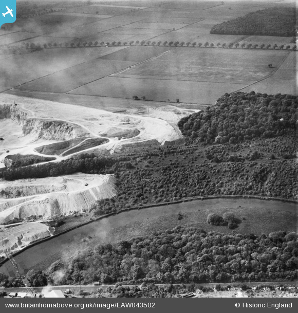
EAW043502 ENGLAND (1952). Quarrying by the edge of Pot Ridings Wood, Cadeby, 1952
© Copyright OpenStreetMap contributors and licensed by the OpenStreetMap Foundation. 2025. Cartography is licensed as CC BY-SA.
Nearby Images (5)
Details
| Title | [EAW043502] Quarrying by the edge of Pot Ridings Wood, Cadeby, 1952 |
| Reference | EAW043502 |
| Date | 21-May-1952 |
| Link | |
| Place name | CADEBY |
| Parish | CADEBY |
| District | |
| Country | ENGLAND |
| Easting / Northing | 452580, 400276 |
| Longitude / Latitude | -1.2073119819091, 53.496304771846 |
| National Grid Reference | SE526003 |
Pins
Be the first to add a comment to this image!


![[EAW043502] Quarrying by the edge of Pot Ridings Wood, Cadeby, 1952](http://britainfromabove.org.uk/sites/all/libraries/aerofilms-images/public/100x100/EAW/043/EAW043502.jpg)
![[EAW047731] Pot Ridings Wood with Sprotbrough Quarry in the distance, Cadeby, from the south-west, 1952](http://britainfromabove.org.uk/sites/all/libraries/aerofilms-images/public/100x100/EAW/047/EAW047731.jpg)
![[EAW047730] Pot Ridings Wood with Sprotbrough Quarry in the distance, Cadeby, from the south-west, 1952](http://britainfromabove.org.uk/sites/all/libraries/aerofilms-images/public/100x100/EAW/047/EAW047730.jpg)
![[EAW043503] Quarrying by the edge of Pot Ridings Wood, Cadeby, 1952](http://britainfromabove.org.uk/sites/all/libraries/aerofilms-images/public/100x100/EAW/043/EAW043503.jpg)
![[EAW043501] Pot Ridings Wood, Cadeby, 1952](http://britainfromabove.org.uk/sites/all/libraries/aerofilms-images/public/100x100/EAW/043/EAW043501.jpg)