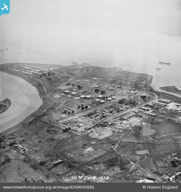
EAW043883 ENGLAND (1952). The Coryton Oil Refinery, Shell Haven, from the north-west, 1952. This image was marked by Aerofilms Ltd for photo editing.
© Copyright OpenStreetMap contributors and licensed by the OpenStreetMap Foundation. 2025. Cartography is licensed as CC BY-SA.
Nearby Images (18)
Details
| Title | [EAW043883] The Coryton Oil Refinery, Shell Haven, from the north-west, 1952. This image was marked by Aerofilms Ltd for photo editing. |
| Reference | EAW043883 |
| Date | 10-June-1952 |
| Link | |
| Place name | SHELL HAVEN |
| Parish | |
| District | |
| Country | ENGLAND |
| Easting / Northing | 574567, 182729 |
| Longitude / Latitude | 0.51621673004894, 51.515989515158 |
| National Grid Reference | TQ746827 |
Pins
Be the first to add a comment to this image!


![[EAW043883] The Coryton Oil Refinery, Shell Haven, from the north-west, 1952. This image was marked by Aerofilms Ltd for photo editing.](http://britainfromabove.org.uk/sites/all/libraries/aerofilms-images/public/100x100/EAW/043/EAW043883.jpg)
![[EAW039880] The Coryton Oil Refinery, Coryton, from the north-west, 1951](http://britainfromabove.org.uk/sites/all/libraries/aerofilms-images/public/100x100/EAW/039/EAW039880.jpg)
![[EAW034445] Part of the Coryton Oil Refinery under construction, Coryton, from the north-west, 1951. This image has been produced from a print marked by Aerofilms Ltd for photo editing.](http://britainfromabove.org.uk/sites/all/libraries/aerofilms-images/public/100x100/EAW/034/EAW034445.jpg)
![[EAW048092] Coryton Oil Refinery and environs, Coryton, 1952. This image was marked by Aerofilms Ltd for photo editing.](http://britainfromabove.org.uk/sites/all/libraries/aerofilms-images/public/100x100/EAW/048/EAW048092.jpg)
![[EAW039897] The Coryton Oil Refinery and the River Thames, Coryton, from the north-west, 1951. This image has been produced from a damaged negative.](http://britainfromabove.org.uk/sites/all/libraries/aerofilms-images/public/100x100/EAW/039/EAW039897.jpg)
![[EAW042275] The Coryton Oil Refinery, Coryton, 1952. This image was marked by Aerofilms Ltd for photo editing.](http://britainfromabove.org.uk/sites/all/libraries/aerofilms-images/public/100x100/EAW/042/EAW042275.jpg)
![[EAW034442] Part of the Coryton Oil Refinery under construction, Coryton, 1951. This image has been produced from a print marked by Aerofilms Ltd for photo editing.](http://britainfromabove.org.uk/sites/all/libraries/aerofilms-images/public/100x100/EAW/034/EAW034442.jpg)
![[EAW045727] The Coryton Oil Refinery, Coryton, 1952. This image was marked by Aerofilms Ltd for photo editing.](http://britainfromabove.org.uk/sites/all/libraries/aerofilms-images/public/100x100/EAW/045/EAW045727.jpg)
![[EAW048093] Coryton Oil Refinery and environs, Coryton, 1952](http://britainfromabove.org.uk/sites/all/libraries/aerofilms-images/public/100x100/EAW/048/EAW048093.jpg)
![[EAW048376] Flooding at the Coryton Oil Refinery, Coryton, from the north-west, 1953. This image was marked by Aerofilms Ltd for photo editing.](http://britainfromabove.org.uk/sites/all/libraries/aerofilms-images/public/100x100/EAW/048/EAW048376.jpg)
![[EAW043884] The Coryton Oil Refinery, Shell Haven, 1952. This image was marked by Aerofilms Ltd for photo editing.](http://britainfromabove.org.uk/sites/all/libraries/aerofilms-images/public/100x100/EAW/043/EAW043884.jpg)
![[EAW039896] The Coryton Oil Refinery and the River Thames, Coryton, from the north-west, 1951. This image has been produced from a damaged negative.](http://britainfromabove.org.uk/sites/all/libraries/aerofilms-images/public/100x100/EAW/039/EAW039896.jpg)
![[EAW048595] The Coryton Oil Refinery under construction, Coryton, 1953. This image was marked by Aerofilms Ltd for photo editing.](http://britainfromabove.org.uk/sites/all/libraries/aerofilms-images/public/100x100/EAW/048/EAW048595.jpg)
![[EAW041998] Coryton Oil Refinery, Corringham, 1952. This image was marked by Aerofilms Ltd for photo editing.](http://britainfromabove.org.uk/sites/all/libraries/aerofilms-images/public/100x100/EAW/041/EAW041998.jpg)
![[EAW039885] The Coryton Oil Refinery, Coryton, 1951](http://britainfromabove.org.uk/sites/all/libraries/aerofilms-images/public/100x100/EAW/039/EAW039885.jpg)
![[EAW048590] The Coryton Oil Refinery under construction, Coryton, 1953. This image was marked by Aerofilms Ltd for photo editing.](http://britainfromabove.org.uk/sites/all/libraries/aerofilms-images/public/100x100/EAW/048/EAW048590.jpg)
![[EAW048374] Flooding at the Coryton Oil Refinery, Coryton, 1953. This image was marked by Aerofilms Ltd for photo editing.](http://britainfromabove.org.uk/sites/all/libraries/aerofilms-images/public/100x100/EAW/048/EAW048374.jpg)
![[EAW035777] Part of the Coryton Oil Refinery, Coryton, 1951. This image has been produced from a print marked by Aerofilms Ltd for photo editing.](http://britainfromabove.org.uk/sites/all/libraries/aerofilms-images/public/100x100/EAW/035/EAW035777.jpg)