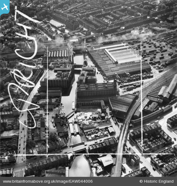
EAW044006 ENGLAND (1952). Industrial buildings along the Grand Union Canal including the Interchange Warehouse, Camden Town, 1952. This image was marked by Aerofilms Ltd for photo editing.
© Copyright OpenStreetMap contributors and licensed by the OpenStreetMap Foundation. 2025. Cartography is licensed as CC BY-SA.
Nearby Images (18)
Details
| Title | [EAW044006] Industrial buildings along the Grand Union Canal including the Interchange Warehouse, Camden Town, 1952. This image was marked by Aerofilms Ltd for photo editing. |
| Reference | EAW044006 |
| Date | 11-June-1952 |
| Link | |
| Place name | CAMDEN TOWN |
| Parish | |
| District | |
| Country | ENGLAND |
| Easting / Northing | 528607, 184081 |
| Longitude / Latitude | -0.1453190554102, 51.540477850239 |
| National Grid Reference | TQ286841 |
Pins
 Class31 |
Saturday 29th of November 2014 07:16:51 PM |


![[EAW044006] Industrial buildings along the Grand Union Canal including the Interchange Warehouse, Camden Town, 1952. This image was marked by Aerofilms Ltd for photo editing.](http://britainfromabove.org.uk/sites/all/libraries/aerofilms-images/public/100x100/EAW/044/EAW044006.jpg)
![[EAW044000] The Interchange Warehouse and Grand Union Canal, Camden Town, 1952. This image was marked by Aerofilms Ltd for photo editing.](http://britainfromabove.org.uk/sites/all/libraries/aerofilms-images/public/100x100/EAW/044/EAW044000.jpg)
![[EAW044005] The Interchange Warehouse, Camden Town, 1952. This image was marked by Aerofilms Ltd for photo editing.](http://britainfromabove.org.uk/sites/all/libraries/aerofilms-images/public/100x100/EAW/044/EAW044005.jpg)
![[EAW044004] The Interchange Warehouse and Grand Union Canal, Camden Town, 1952. This image was marked by Aerofilms Ltd for photo editing.](http://britainfromabove.org.uk/sites/all/libraries/aerofilms-images/public/100x100/EAW/044/EAW044004.jpg)
![[EAW044002] The Interchange Warehouse, Camden Town, 1952. This image was marked by Aerofilms Ltd for photo editing.](http://britainfromabove.org.uk/sites/all/libraries/aerofilms-images/public/100x100/EAW/044/EAW044002.jpg)
![[EAW044003] The Interchange Warehouse, Camden Town, 1952. This image was marked by Aerofilms Ltd for photo editing.](http://britainfromabove.org.uk/sites/all/libraries/aerofilms-images/public/100x100/EAW/044/EAW044003.jpg)
![[EAW043999] The Interchange Warehouse and Grand Union Canal, Camden Town, 1952. This image was marked by Aerofilms Ltd for photo editing.](http://britainfromabove.org.uk/sites/all/libraries/aerofilms-images/public/100x100/EAW/043/EAW043999.jpg)
![[EAW044007] The Interchange Warehouse, Camden Town, 1952. This image was marked by Aerofilms Ltd for photo editing.](http://britainfromabove.org.uk/sites/all/libraries/aerofilms-images/public/100x100/EAW/044/EAW044007.jpg)
![[EAW044009] The Interchange Warehouse and environs, Camden Town, 1952. This image was marked by Aerofilms Ltd for photo editing.](http://britainfromabove.org.uk/sites/all/libraries/aerofilms-images/public/100x100/EAW/044/EAW044009.jpg)
![[EAW044001] The Interchange Warehouse and Grand Union Canal, Camden Town, 1952. This image was marked by Aerofilms Ltd for photo editing.](http://britainfromabove.org.uk/sites/all/libraries/aerofilms-images/public/100x100/EAW/044/EAW044001.jpg)
![[EAW044008] The Interchange Warehouse, Grand Union Canal and environs, Camden Town, 1952. This image was marked by Aerofilms Ltd for photo editing.](http://britainfromabove.org.uk/sites/all/libraries/aerofilms-images/public/100x100/EAW/044/EAW044008.jpg)
![[EPW007014] Oval Road and the Pianoforte Manufactory, Camden Town, 1921](http://britainfromabove.org.uk/sites/all/libraries/aerofilms-images/public/100x100/EPW/007/EPW007014.jpg)
![[EPW007015] The Pianoforte Manufactory on Oval Road, Camden Town, 1921](http://britainfromabove.org.uk/sites/all/libraries/aerofilms-images/public/100x100/EPW/007/EPW007015.jpg)
![[EPW007017] The Pianoforte Manufactory on Oval Road, Camden Town, 1921](http://britainfromabove.org.uk/sites/all/libraries/aerofilms-images/public/100x100/EPW/007/EPW007017.jpg)
![[EPW007018] The Pianoforte Manufactory on Oval Road, Camden Town, 1921](http://britainfromabove.org.uk/sites/all/libraries/aerofilms-images/public/100x100/EPW/007/EPW007018.jpg)
![[EPW007016] The Pianoforte Manufactory, Gilbey's and the Camden Goods Station, Camden Town, 1921](http://britainfromabove.org.uk/sites/all/libraries/aerofilms-images/public/100x100/EPW/007/EPW007016.jpg)
![[EPW007019] The Pianoforte Manufactory, Gilbey's and Camden Goods Station, Camden Town, 1921](http://britainfromabove.org.uk/sites/all/libraries/aerofilms-images/public/100x100/EPW/007/EPW007019.jpg)
![[EAW000624] A cityscape over Kentish Town, Camden Town, from the south-west, 1946](http://britainfromabove.org.uk/sites/all/libraries/aerofilms-images/public/100x100/EAW/000/EAW000624.jpg)