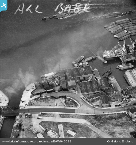
EAW045698 ENGLAND (1952). Dinorwic Wharf and Surrey Commercial Wharf, Surrey Docks, 1952. This image was marked by Aerofilms Ltd for photo editing.
© Copyright OpenStreetMap contributors and licensed by the OpenStreetMap Foundation. 2025. Cartography is licensed as CC BY-SA.
Nearby Images (15)
Details
| Title | [EAW045698] Dinorwic Wharf and Surrey Commercial Wharf, Surrey Docks, 1952. This image was marked by Aerofilms Ltd for photo editing. |
| Reference | EAW045698 |
| Date | 5-August-1952 |
| Link | |
| Place name | SURREY DOCKS |
| Parish | |
| District | |
| Country | ENGLAND |
| Easting / Northing | 535616, 180272 |
| Longitude / Latitude | -0.04576815876039, 51.504604684184 |
| National Grid Reference | TQ356803 |
Pins
Be the first to add a comment to this image!


![[EAW045698] Dinorwic Wharf and Surrey Commercial Wharf, Surrey Docks, 1952. This image was marked by Aerofilms Ltd for photo editing.](http://britainfromabove.org.uk/sites/all/libraries/aerofilms-images/public/100x100/EAW/045/EAW045698.jpg)
![[EAW045700] Dinorwic Wharf and Surrey Commercial Wharf, Surrey Docks, 1952. This image was marked by Aerofilms Ltd for photo editing.](http://britainfromabove.org.uk/sites/all/libraries/aerofilms-images/public/100x100/EAW/045/EAW045700.jpg)
![[EAW045704] Surrey Commercial Wharf and Rotherhithe Street, Surrey Docks, 1952. This image has been produced from a damaged negative.](http://britainfromabove.org.uk/sites/all/libraries/aerofilms-images/public/100x100/EAW/045/EAW045704.jpg)
![[EAW045703] Dinorwic Wharf, Surrey Commercial Wharf and Bellamy's Wharf, Surrey Docks, 1952. This image was marked by Aerofilms Ltd for photo editing.](http://britainfromabove.org.uk/sites/all/libraries/aerofilms-images/public/100x100/EAW/045/EAW045703.jpg)
![[EAW045702] Dinorwic Wharf and Surrey Commercial Wharf and Stave Dock, Surrey Docks, 1952. This image was marked by Aerofilms Ltd for photo editing.](http://britainfromabove.org.uk/sites/all/libraries/aerofilms-images/public/100x100/EAW/045/EAW045702.jpg)
![[EAW045699] Surrey Commercial Wharf and Bellamy's Wharf, Surrey Docks, 1952. This image was marked by Aerofilms Ltd for photo editing.](http://britainfromabove.org.uk/sites/all/libraries/aerofilms-images/public/100x100/EAW/045/EAW045699.jpg)
![[EAW045701] Dinorwic Wharf and Surrey Commercial Wharf and Surrey Basin, Surrey Docks, 1952. This image was marked by Aerofilms Ltd for photo editing.](http://britainfromabove.org.uk/sites/all/libraries/aerofilms-images/public/100x100/EAW/045/EAW045701.jpg)
![[EPW009339] Bellamys Wharf, Rotherhithe, 1923](http://britainfromabove.org.uk/sites/all/libraries/aerofilms-images/public/100x100/EPW/009/EPW009339.jpg)
![[EPW009340] Bellamys Wharf, Rotherhithe, 1923](http://britainfromabove.org.uk/sites/all/libraries/aerofilms-images/public/100x100/EPW/009/EPW009340.jpg)
![[EPW009114] Bellamy's Wharf, Rotherhithe, 1923. This image has been produced from a print.](http://britainfromabove.org.uk/sites/all/libraries/aerofilms-images/public/100x100/EPW/009/EPW009114.jpg)
![[EPW009338] Bellemy's Wharf, Rotherhithe, 1923. This image has been produced from a print.](http://britainfromabove.org.uk/sites/all/libraries/aerofilms-images/public/100x100/EPW/009/EPW009338.jpg)
![[EPW009099] Surrey Commercial Docks, Rotherhithe, 1923](http://britainfromabove.org.uk/sites/all/libraries/aerofilms-images/public/100x100/EPW/009/EPW009099.jpg)
![[EPW060799] Surrey Commercial Docks and environs, Rotherhithe, 1939](http://britainfromabove.org.uk/sites/all/libraries/aerofilms-images/public/100x100/EPW/060/EPW060799.jpg)
![[EAW025480] The London Docks and River Thames, Wapping, from the north-east, 1949. This image has been produced from a print.](http://britainfromabove.org.uk/sites/all/libraries/aerofilms-images/public/100x100/EAW/025/EAW025480.jpg)
![[EAW022336] The London Docks and the city, Wapping, from the south-east, 1949](http://britainfromabove.org.uk/sites/all/libraries/aerofilms-images/public/100x100/EAW/022/EAW022336.jpg)