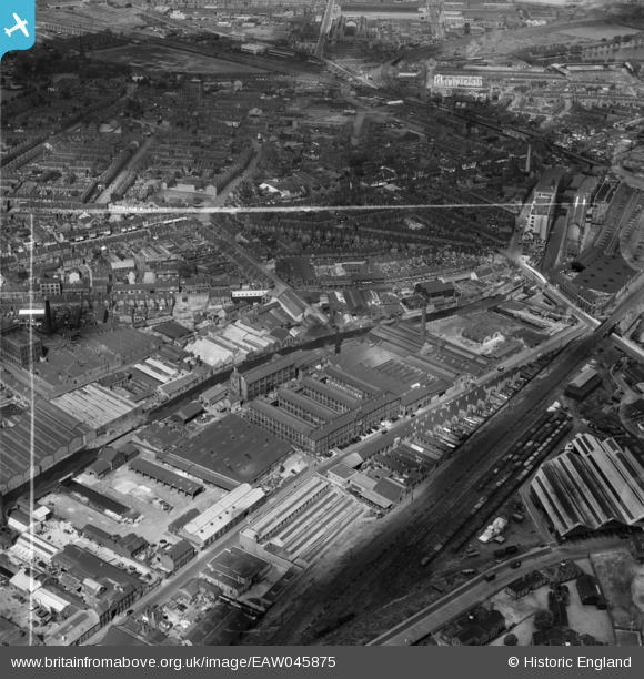
EAW045875 ENGLAND (1952). The British Timken Ltd Roller Bearing Works on Cheston Road and surrounding factories, Aston, 1952. This image was marked by Aerofilms Ltd for photo editing.
© Copyright OpenStreetMap contributors and licensed by the OpenStreetMap Foundation. 2025. Cartography is licensed as CC BY-SA.
Nearby Images (26)
Details
| Title | [EAW045875] The British Timken Ltd Roller Bearing Works on Cheston Road and surrounding factories, Aston, 1952. This image was marked by Aerofilms Ltd for photo editing. |
| Reference | EAW045875 |
| Date | 14-August-1952 |
| Link | |
| Place name | ASTON |
| Parish | |
| District | |
| Country | ENGLAND |
| Easting / Northing | 408543, 289113 |
| Longitude / Latitude | -1.874140574945, 52.499486393613 |
| National Grid Reference | SP085891 |
Pins
 J May |
Wednesday 2nd of October 2024 01:01:05 PM | |
 H.E. |
Friday 6th of September 2024 07:43:50 PM | |
 H.E. |
Friday 6th of September 2024 07:43:07 PM | |
 H.E. |
Friday 6th of September 2024 07:39:29 PM | |
 MATTY |
Wednesday 11th of November 2015 03:46:32 PM | |
 Griffin |
Monday 26th of October 2015 02:36:18 PM | |
 Griffin |
Monday 26th of October 2015 02:28:25 PM | |
 Griffin |
Monday 26th of October 2015 02:25:34 PM | |
 Griffin |
Monday 26th of October 2015 02:13:03 PM | |
 Griffin |
Monday 26th of October 2015 02:03:19 PM | |
 Griffin |
Monday 26th of October 2015 01:51:53 PM | |
 Griffin |
Monday 26th of October 2015 01:43:54 PM | |
 Griffin |
Monday 26th of October 2015 12:35:34 PM | |
 Griffin |
Monday 26th of October 2015 11:52:24 AM | |
 Griffin |
Monday 26th of October 2015 11:48:29 AM | |
 Griffin |
Monday 26th of October 2015 11:42:50 AM | |
 Griffin |
Monday 26th of October 2015 11:39:11 AM | |
 Griffin |
Monday 26th of October 2015 11:35:10 AM | |
 Griffin |
Monday 26th of October 2015 11:33:27 AM |


![[EAW045875] The British Timken Ltd Roller Bearing Works on Cheston Road and surrounding factories, Aston, 1952. This image was marked by Aerofilms Ltd for photo editing.](http://britainfromabove.org.uk/sites/all/libraries/aerofilms-images/public/100x100/EAW/045/EAW045875.jpg)
![[EPW061177] The British Timken Roller Bearing Works on Cheston Road and environs, Aston, 1939](http://britainfromabove.org.uk/sites/all/libraries/aerofilms-images/public/100x100/EPW/061/EPW061177.jpg)
![[EAW045884] The British Timken Ltd Roller Bearing Works on Cheston Road and surrounding factories alongside the Birmingham and Fazeley Canal, Aston, 1952. This image was marked by Aerofilms Ltd for photo editing.](http://britainfromabove.org.uk/sites/all/libraries/aerofilms-images/public/100x100/EAW/045/EAW045884.jpg)
![[EPW061174] The British Timken Roller Bearing Works on Cheston Road and environs, Aston, 1939](http://britainfromabove.org.uk/sites/all/libraries/aerofilms-images/public/100x100/EPW/061/EPW061174.jpg)
![[EAW045878] The British Timken Ltd Roller Bearing Works on Cheston Road and surrounding factories alongside the Birmingham and Fazeley Canal, Aston, 1952. This image was marked by Aerofilms Ltd for photo editing.](http://britainfromabove.org.uk/sites/all/libraries/aerofilms-images/public/100x100/EAW/045/EAW045878.jpg)
![[EPW046033] The British Timken Ltd Roller Bearing Works and other factories on Cheston Road, Aston, 1934](http://britainfromabove.org.uk/sites/all/libraries/aerofilms-images/public/100x100/EPW/046/EPW046033.jpg)
![[EPW046037] The British Timken Ltd Roller Bearing Works, Aston, 1934](http://britainfromabove.org.uk/sites/all/libraries/aerofilms-images/public/100x100/EPW/046/EPW046037.jpg)
![[EPW046035] The British Timken Ltd Roller Bearing Works, Aston, 1934. This image has been produced from a damaged negative.](http://britainfromabove.org.uk/sites/all/libraries/aerofilms-images/public/100x100/EPW/046/EPW046035.jpg)
![[EAW045881] The British Timken Ltd Roller Bearing Works on Cheston Road and surrounding factories alongside the Birmingham and Fazeley Canal, Aston, 1952. This image was marked by Aerofilms Ltd for photo editing.](http://britainfromabove.org.uk/sites/all/libraries/aerofilms-images/public/100x100/EAW/045/EAW045881.jpg)
![[EAW045879] The British Timken Ltd Roller Bearing Works on Cheston Road and surrounding factories, Aston, 1952. This image was marked by Aerofilms Ltd for photo editing.](http://britainfromabove.org.uk/sites/all/libraries/aerofilms-images/public/100x100/EAW/045/EAW045879.jpg)
![[EAW045877] The British Timken Ltd Roller Bearing Works on Cheston Road and surrounding factories alongside the Birmingham and Fazeley Canal, Aston, 1952. This image was marked by Aerofilms Ltd for photo editing.](http://britainfromabove.org.uk/sites/all/libraries/aerofilms-images/public/100x100/EAW/045/EAW045877.jpg)
![[EAW045876] The British Timken Ltd Roller Bearing Works on Cheston Road and surrounding factories, Aston, 1952. This image was marked by Aerofilms Ltd for photo editing.](http://britainfromabove.org.uk/sites/all/libraries/aerofilms-images/public/100x100/EAW/045/EAW045876.jpg)
![[EAW045882] The British Timken Ltd Roller Bearing Works on Cheston Road and surrounding factories alongside the Birmingham and Fazeley Canal, Aston, 1952. This image was marked by Aerofilms Ltd for photo editing.](http://britainfromabove.org.uk/sites/all/libraries/aerofilms-images/public/100x100/EAW/045/EAW045882.jpg)
![[EAW045883] The British Timken Ltd Roller Bearing Works on Cheston Road and surrounding factories alongside the Birmingham and Fazeley Canal, Aston, 1952. This image was marked by Aerofilms Ltd for photo editing.](http://britainfromabove.org.uk/sites/all/libraries/aerofilms-images/public/100x100/EAW/045/EAW045883.jpg)
![[EAW045885] The British Timken Ltd Roller Bearing Works on Cheston Road and surrounding factories alongside the Birmingham and Fazeley Canal, Aston, 1952. This image was marked by Aerofilms Ltd for photo editing.](http://britainfromabove.org.uk/sites/all/libraries/aerofilms-images/public/100x100/EAW/045/EAW045885.jpg)
![[EAW045880] The British Timken Ltd Roller Bearing Works on Cheston Road and surrounding factories alongside the Birmingham and Fazeley Canal, Aston, 1952. This image was marked by Aerofilms Ltd for photo editing.](http://britainfromabove.org.uk/sites/all/libraries/aerofilms-images/public/100x100/EAW/045/EAW045880.jpg)
![[EPW046036] The British Timken Ltd Roller Bearing Works, Aston, 1934](http://britainfromabove.org.uk/sites/all/libraries/aerofilms-images/public/100x100/EPW/046/EPW046036.jpg)
![[EPW061178] The British Timken Roller Bearing Works on Cheston Road and environs, Aston, 1939](http://britainfromabove.org.uk/sites/all/libraries/aerofilms-images/public/100x100/EPW/061/EPW061178.jpg)
![[EPW061173] The British Timken Roller Bearing Works on Cheston Road and environs, Aston, 1939](http://britainfromabove.org.uk/sites/all/libraries/aerofilms-images/public/100x100/EPW/061/EPW061173.jpg)
![[EPW046031] The British Timken Ltd Roller Bearing Works and other factories on Cheston Road, Aston, 1934](http://britainfromabove.org.uk/sites/all/libraries/aerofilms-images/public/100x100/EPW/046/EPW046031.jpg)
![[EPW046034] The British Timken Ltd Roller Bearing Works and other factories on Cheston Road, Aston, 1934](http://britainfromabove.org.uk/sites/all/libraries/aerofilms-images/public/100x100/EPW/046/EPW046034.jpg)
![[EPW061175] The British Timken Roller Bearing Works on Cheston Road and environs, Aston, 1939](http://britainfromabove.org.uk/sites/all/libraries/aerofilms-images/public/100x100/EPW/061/EPW061175.jpg)
![[EPW061179] The British Timken Roller Bearing Works on Cheston Road and environs, Aston, 1939](http://britainfromabove.org.uk/sites/all/libraries/aerofilms-images/public/100x100/EPW/061/EPW061179.jpg)
![[EPW061176] The British Timken Roller Bearing Works on Cheston Road and environs, Aston, from the south-east, 1939](http://britainfromabove.org.uk/sites/all/libraries/aerofilms-images/public/100x100/EPW/061/EPW061176.jpg)
![[EPW046038] The British Timken Ltd Roller Bearing Works, Aston, from the south-east, 1934](http://britainfromabove.org.uk/sites/all/libraries/aerofilms-images/public/100x100/EPW/046/EPW046038.jpg)
![[EPW046032] The British Timken Ltd Roller Bearing Works and other factories on Cheston Road, Aston, from the east, 1934](http://britainfromabove.org.uk/sites/all/libraries/aerofilms-images/public/100x100/EPW/046/EPW046032.jpg)