
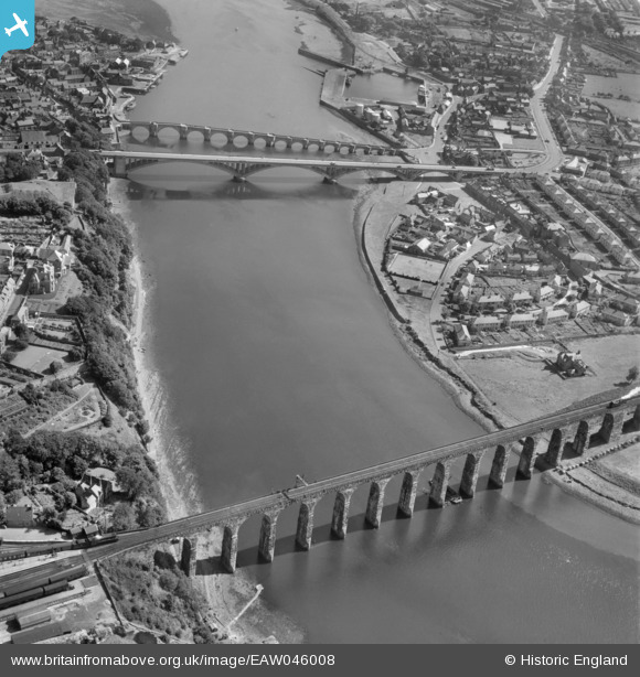
EAW046008 ENGLAND (1952). The Royal Border, Royal Tweed and Berwick Bridges, Berwick-upon-Tweed, 1952
© Copyright OpenStreetMap contributors and licensed by the OpenStreetMap Foundation. 2025. Cartography is licensed as CC BY-SA.
Nearby Images (6)
EAW046008

EAW046411

EPW040675

EAW046009

EAW046007

EPW040679

Details
| Title | [EAW046008] The Royal Border, Royal Tweed and Berwick Bridges, Berwick-upon-Tweed, 1952 |
| Reference | EAW046008 |
| Date | 14-August-1952 |
| Link | |
| Place name | BERWICK-UPON-TWEED |
| Parish | BERWICK-UPON-TWEED |
| District | |
| Country | ENGLAND |
| Easting / Northing | 399408, 653020 |
| Longitude / Latitude | -2.0094371562696, 55.770536477325 |
| National Grid Reference | NT994530 |
Pins
 Matt Aldred edob.mattaldred.com |
Thursday 31st of December 2020 02:47:23 PM | |
 |
 melgibbs |
Wednesday 14th of October 2015 06:48:41 PM |
 John Wass |
Wednesday 16th of July 2014 11:16:40 AM |