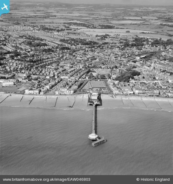
EAW046803 ENGLAND (1952). The pier and the town, Bognor Regis, from the south, 1952
© Copyright OpenStreetMap contributors and licensed by the OpenStreetMap Foundation. 2025. Cartography is licensed as CC BY-SA.
Nearby Images (13)
EAW046803

EAW046804

EPW040108

EPW040100

EAW046504

EAW022233

EPW040107

EPW040105

EPW000760

EAW022236

EPW040103

EAW022235

EAW046503

Details
| Title | [EAW046803] The pier and the town, Bognor Regis, from the south, 1952 |
| Reference | EAW046803 |
| Date | 16-September-1952 |
| Link | |
| Place name | BOGNOR REGIS |
| Parish | BOGNOR REGIS |
| District | |
| Country | ENGLAND |
| Easting / Northing | 493446, 98687 |
| Longitude / Latitude | -0.67440105635756, 50.779655397487 |
| National Grid Reference | SZ934987 |
Pins
 |
 ordinarybloke |
Monday 27th of February 2023 02:27:35 PM |
Stephen Mirrington |
Wednesday 25th of August 2021 09:14:51 AM | |
Stephen Mirrington |
Wednesday 25th of August 2021 09:12:46 AM | |
ordinarybloke |
Thursday 14th of January 2016 12:06:47 PM | |
ordinarybloke |
Wednesday 6th of January 2016 11:09:48 AM | |
 |
ordinarybloke |
Thursday 3rd of December 2015 02:58:04 PM |
ordinarybloke |
Monday 9th of June 2014 01:10:18 PM |