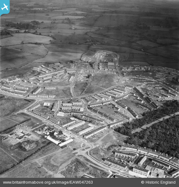
EAW047263 ENGLAND (1952). The residential areas at Whomerley Wood and Bedwell North under construction, Bedwell, from the south-west, 1952
© Copyright OpenStreetMap contributors and licensed by the OpenStreetMap Foundation. 2025. Cartography is licensed as CC BY-SA.
Nearby Images (11)
Details
| Title | [EAW047263] The residential areas at Whomerley Wood and Bedwell North under construction, Bedwell, from the south-west, 1952 |
| Reference | EAW047263 |
| Date | 15-October-1952 |
| Link | |
| Place name | BEDWELL |
| Parish | |
| District | |
| Country | ENGLAND |
| Easting / Northing | 524492, 223916 |
| Longitude / Latitude | -0.19039057712023, 51.899426290376 |
| National Grid Reference | TL245239 |


![[EAW047263] The residential areas at Whomerley Wood and Bedwell North under construction, Bedwell, from the south-west, 1952](http://britainfromabove.org.uk/sites/all/libraries/aerofilms-images/public/100x100/EAW/047/EAW047263.jpg)
![[EAW047265] The residential areas at Whomerley Wood and Bedwell North under construction, Bedwell, from the south-west, 1952](http://britainfromabove.org.uk/sites/all/libraries/aerofilms-images/public/100x100/EAW/047/EAW047265.jpg)
![[EAW047262] The residential areas at Whomerley Wood and Bedwell East under construction, Bedwell, from the south-west, 1952](http://britainfromabove.org.uk/sites/all/libraries/aerofilms-images/public/100x100/EAW/047/EAW047262.jpg)
![[EAW041980] Development of Bedwell and Monkswood, Stevenage, 1952](http://britainfromabove.org.uk/sites/all/libraries/aerofilms-images/public/100x100/EAW/041/EAW041980.jpg)
![[EAW041985] Development of Monkswood and Bedwell, Stevenage, 1952](http://britainfromabove.org.uk/sites/all/libraries/aerofilms-images/public/100x100/EAW/041/EAW041985.jpg)
![[EAW047261] The residential areas at Whomerley Wood and Bedwell North under construction, Bedwell, from the south, 1952](http://britainfromabove.org.uk/sites/all/libraries/aerofilms-images/public/100x100/EAW/047/EAW047261.jpg)
![[EAW047260] The residential areas at Whomerley Wood and Bedwell East under construction, Bedwell, from the south-west, 1952. This image was marked by Aerofilms Ltd for photo editing.](http://britainfromabove.org.uk/sites/all/libraries/aerofilms-images/public/100x100/EAW/047/EAW047260.jpg)
![[EAW053198] St Andrew's Church on Bedwell Crescent, Stevenage, 1954](http://britainfromabove.org.uk/sites/all/libraries/aerofilms-images/public/100x100/EAW/053/EAW053198.jpg)
![[EAW053196] St Andrew's Church on Bedwell Crescent, Stevenage, 1954](http://britainfromabove.org.uk/sites/all/libraries/aerofilms-images/public/100x100/EAW/053/EAW053196.jpg)
![[EAW053197] St Andrew's Church on Bedwell Crescent, Stevenage, 1954](http://britainfromabove.org.uk/sites/all/libraries/aerofilms-images/public/100x100/EAW/053/EAW053197.jpg)
![[EAW032037] The Monkswood Estate in the early stages of construction and environs, Stevenage, 1950](http://britainfromabove.org.uk/sites/all/libraries/aerofilms-images/public/100x100/EAW/032/EAW032037.jpg)
