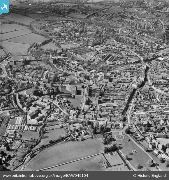
EAW049104 ENGLAND (1953). The town centre, Taunton, 1953
© Copyright OpenStreetMap contributors and licensed by the OpenStreetMap Foundation. 2025. Cartography is licensed as CC BY-SA.
Nearby Images (37)
Details
| Title | [EAW049104] The town centre, Taunton, 1953 |
| Reference | EAW049104 |
| Date | 6-May-1953 |
| Link | |
| Place name | TAUNTON |
| Parish | |
| District | |
| Country | ENGLAND |
| Easting / Northing | 322494, 124416 |
| Longitude / Latitude | -3.1049897911524, 51.01335492357 |
| National Grid Reference | ST225244 |
Pins
 redmist |
Sunday 17th of December 2023 04:20:05 PM | |
 redmist |
Sunday 17th of December 2023 04:17:50 PM | |
 Newbie20 |
Thursday 25th of February 2021 07:22:42 AM | |
 Newbie20 |
Thursday 25th of February 2021 07:06:57 AM | |
 Somerset Chick |
Saturday 18th of March 2017 11:25:51 PM | |
 Somerset Chick |
Saturday 18th of March 2017 11:24:48 PM |


![[EAW049104] The town centre, Taunton, 1953](http://britainfromabove.org.uk/sites/all/libraries/aerofilms-images/public/100x100/EAW/049/EAW049104.jpg)
![[EAW051946] The town centre, Taunton, 1953](http://britainfromabove.org.uk/sites/all/libraries/aerofilms-images/public/100x100/EAW/051/EAW051946.jpg)
![[EAW005344] The Shire Hall, County Hall and the surrounding area, Taunton, 1947](http://britainfromabove.org.uk/sites/all/libraries/aerofilms-images/public/100x100/EAW/005/EAW005344.jpg)
![[EAW005139] The Shire Hall and County Hall, Taunton, 1947](http://britainfromabove.org.uk/sites/all/libraries/aerofilms-images/public/100x100/EAW/005/EAW005139.jpg)
![[EAW005138] The Shire Hall, County Hall and the High Street, Taunton, 1947](http://britainfromabove.org.uk/sites/all/libraries/aerofilms-images/public/100x100/EAW/005/EAW005138.jpg)
![[EAW015039] Shire Hall and County Hall, Taunton, 1948. This image has been produced from a print.](http://britainfromabove.org.uk/sites/all/libraries/aerofilms-images/public/100x100/EAW/015/EAW015039.jpg)
![[EPW041182] The Gaumont Palace Cinema and Corporation Street, Taunton, 1933](http://britainfromabove.org.uk/sites/all/libraries/aerofilms-images/public/100x100/EPW/041/EPW041182.jpg)
![[EAW005345] County Hall, the Shire Hall and the Police Station, Taunton, 1947](http://britainfromabove.org.uk/sites/all/libraries/aerofilms-images/public/100x100/EAW/005/EAW005345.jpg)
![[EAW051945] The town centre, Taunton, 1953. This image was marked by Aerofilms Ltd for photo editing.](http://britainfromabove.org.uk/sites/all/libraries/aerofilms-images/public/100x100/EAW/051/EAW051945.jpg)
![[EAW049103] The town centre, Taunton, 1953](http://britainfromabove.org.uk/sites/all/libraries/aerofilms-images/public/100x100/EAW/049/EAW049103.jpg)
![[EAW051942] St John's Church, County Hall and Shire Hall, Taunton, 1953. This image was marked by Aerofilms Ltd for photo editing.](http://britainfromabove.org.uk/sites/all/libraries/aerofilms-images/public/100x100/EAW/051/EAW051942.jpg)
![[EAW015037] Shire Hall and County Hall, Taunton, 1948. This image has been produced from a print.](http://britainfromabove.org.uk/sites/all/libraries/aerofilms-images/public/100x100/EAW/015/EAW015037.jpg)
![[EAW005140] St John's Church, the Shire Hall and County Hall, Taunton, 1947](http://britainfromabove.org.uk/sites/all/libraries/aerofilms-images/public/100x100/EAW/005/EAW005140.jpg)
![[EAW005136] St John's Church, the Shire Hall and County Hall, Taunton, 1947](http://britainfromabove.org.uk/sites/all/libraries/aerofilms-images/public/100x100/EAW/005/EAW005136.jpg)
![[EPW027891] Shire Hall, Taunton, 1929. This image has been produced from a copy-negative.](http://britainfromabove.org.uk/sites/all/libraries/aerofilms-images/public/100x100/EPW/027/EPW027891.jpg)
![[EAW015038] Shire Hall and County Hall, Taunton, 1948. This image has been produced from a print.](http://britainfromabove.org.uk/sites/all/libraries/aerofilms-images/public/100x100/EAW/015/EAW015038.jpg)
![[EAW005137] The Shire Hall, Taunton, 1947](http://britainfromabove.org.uk/sites/all/libraries/aerofilms-images/public/100x100/EAW/005/EAW005137.jpg)
![[EAW005135] St John's Church, the Shire Hall and County Hall, Taunton, 1947](http://britainfromabove.org.uk/sites/all/libraries/aerofilms-images/public/100x100/EAW/005/EAW005135.jpg)
![[EAW051947] The town centre, Taunton, 1953. This image was marked by Aerofilms Ltd for photo editing.](http://britainfromabove.org.uk/sites/all/libraries/aerofilms-images/public/100x100/EAW/051/EAW051947.jpg)
![[EAW051943] The town centre, Taunton, 1953. This image was marked by Aerofilms Ltd for photo editing.](http://britainfromabove.org.uk/sites/all/libraries/aerofilms-images/public/100x100/EAW/051/EAW051943.jpg)
![[EAW005346] The town, Taunton, 1947](http://britainfromabove.org.uk/sites/all/libraries/aerofilms-images/public/100x100/EAW/005/EAW005346.jpg)
![[EAW005141] St John's Church, the Shire Hall and County Hall, Taunton, from the south, 1947](http://britainfromabove.org.uk/sites/all/libraries/aerofilms-images/public/100x100/EAW/005/EAW005141.jpg)
![[EAW005340] The remains of Taunton Castle, Taunton, 1947](http://britainfromabove.org.uk/sites/all/libraries/aerofilms-images/public/100x100/EAW/005/EAW005340.jpg)
![[EAW051948] North Town and environs, Taunton, 1953. This image was marked by Aerofilms Ltd for photo editing.](http://britainfromabove.org.uk/sites/all/libraries/aerofilms-images/public/100x100/EAW/051/EAW051948.jpg)
![[EAW005342] The remains of Taunton Castle and environs, Taunton, 1947. This image has been produced from a print.](http://britainfromabove.org.uk/sites/all/libraries/aerofilms-images/public/100x100/EAW/005/EAW005342.jpg)
![[EPW027886] North Street, the Cattle Market and the town centre, Taunton, 1929. This image has been produced from a copy-negative.](http://britainfromabove.org.uk/sites/all/libraries/aerofilms-images/public/100x100/EPW/027/EPW027886.jpg)
![[EPW013541] The Market House, Fore Street and environs, Taunton, 1925. This image has been produced from a copy-negative.](http://britainfromabove.org.uk/sites/all/libraries/aerofilms-images/public/100x100/EPW/013/EPW013541.jpg)
![[EPW041184] Castle Green and the Castle Hotel, Taunton, 1933](http://britainfromabove.org.uk/sites/all/libraries/aerofilms-images/public/100x100/EPW/041/EPW041184.jpg)
![[EPW013545] Upper High Street and environs, Taunton, 1925. This image has been produced from a copy-negative.](http://britainfromabove.org.uk/sites/all/libraries/aerofilms-images/public/100x100/EPW/013/EPW013545.jpg)
![[EPW027892] The town centre, Taunton, 1929. This image has been produced from a print.](http://britainfromabove.org.uk/sites/all/libraries/aerofilms-images/public/100x100/EPW/027/EPW027892.jpg)
![[EAW005337] The remains of Taunton Castle, Taunton, 1947. This image has been produced from a print.](http://britainfromabove.org.uk/sites/all/libraries/aerofilms-images/public/100x100/EAW/005/EAW005337.jpg)
![[EPW041183] Castle Green and excavation at the Castle Hotel, Taunton, 1933](http://britainfromabove.org.uk/sites/all/libraries/aerofilms-images/public/100x100/EPW/041/EPW041183.jpg)
![[EPW041094] North Street and excavation at the Castle Hotel, Taunton, 1933](http://britainfromabove.org.uk/sites/all/libraries/aerofilms-images/public/100x100/EPW/041/EPW041094.jpg)
![[EAW005347] The town, Taunton, 1947](http://britainfromabove.org.uk/sites/all/libraries/aerofilms-images/public/100x100/EAW/005/EAW005347.jpg)
![[EAW005341] The remains of Taunton Castle, Taunton, 1947](http://britainfromabove.org.uk/sites/all/libraries/aerofilms-images/public/100x100/EAW/005/EAW005341.jpg)
![[EAW005339] The remains of Taunton Castle and environs, Taunton, 1947. This image has been produced from a print.](http://britainfromabove.org.uk/sites/all/libraries/aerofilms-images/public/100x100/EAW/005/EAW005339.jpg)
![[EPW041093] North Street and excavation at the Castle Hotel, Taunton, 1933](http://britainfromabove.org.uk/sites/all/libraries/aerofilms-images/public/100x100/EPW/041/EPW041093.jpg)