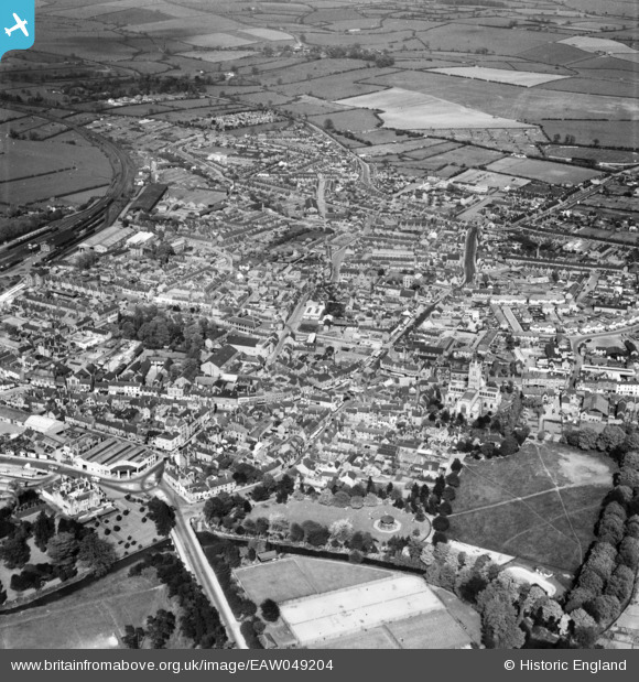
EAW049204 ENGLAND (1953). The town, Melton Mowbray, 1953
© Copyright OpenStreetMap contributors and licensed by the OpenStreetMap Foundation. 2025. Cartography is licensed as CC BY-SA.
Nearby Images (13)
Details
| Title | [EAW049204] The town, Melton Mowbray, 1953 |
| Reference | EAW049204 |
| Date | 11-May-1953 |
| Link | |
| Place name | MELTON MOWBRAY |
| Parish | |
| District | |
| Country | ENGLAND |
| Easting / Northing | 475359, 319207 |
| Longitude / Latitude | -0.88302036232988, 52.764863395428 |
| National Grid Reference | SK754192 |
Pins
 Paul |
Thursday 5th of September 2024 12:31:04 PM | |
 Paul |
Thursday 5th of September 2024 12:28:10 PM | |
 Paul |
Thursday 5th of September 2024 12:26:57 PM | |
 Paul |
Thursday 5th of September 2024 12:23:20 PM | |
 Paul |
Thursday 5th of September 2024 12:21:56 PM | |
 Class31 |
Wednesday 3rd of September 2014 02:03:58 PM | |
 Class31 |
Wednesday 3rd of September 2014 02:02:59 PM | |
 Class31 |
Wednesday 3rd of September 2014 02:01:35 PM | |
 Class31 |
Wednesday 3rd of September 2014 02:00:17 PM | |
 Class31 |
Wednesday 3rd of September 2014 01:59:21 PM |


![[EAW049204] The town, Melton Mowbray, 1953](http://britainfromabove.org.uk/sites/all/libraries/aerofilms-images/public/100x100/EAW/049/EAW049204.jpg)
![[EAW049205] The town, Melton Mowbray, 1953](http://britainfromabove.org.uk/sites/all/libraries/aerofilms-images/public/100x100/EAW/049/EAW049205.jpg)
![[EAW042527] St Mary's Church and the town centre, Melton Mowbray, 1952](http://britainfromabove.org.uk/sites/all/libraries/aerofilms-images/public/100x100/EAW/042/EAW042527.jpg)
![[EPW014945] St Mary's Church and Sherrard Street, Melton Mowbray, 1926. This image has been produced from a copy-negative.](http://britainfromabove.org.uk/sites/all/libraries/aerofilms-images/public/100x100/EPW/014/EPW014945.jpg)
![[EAW042528] The town centre, Melton Mowbray, 1952](http://britainfromabove.org.uk/sites/all/libraries/aerofilms-images/public/100x100/EAW/042/EAW042528.jpg)
![[EPW014946] Norman Street, Melton Mowbray, 1926. This image has been produced from a copy-negative.](http://britainfromabove.org.uk/sites/all/libraries/aerofilms-images/public/100x100/EPW/014/EPW014946.jpg)
![[EPW058214] St Mary's Church and the town centre, melton Mowbray, 1938](http://britainfromabove.org.uk/sites/all/libraries/aerofilms-images/public/100x100/EPW/058/EPW058214.jpg)
![[EPW014943] St Mary's Church, Melton Mowbray, 1926. This image has been produced from a copy-negative.](http://britainfromabove.org.uk/sites/all/libraries/aerofilms-images/public/100x100/EPW/014/EPW014943.jpg)
![[EPW058210] St Mary's Church and the town centre, Melton Mowbray, 1938](http://britainfromabove.org.uk/sites/all/libraries/aerofilms-images/public/100x100/EPW/058/EPW058210.jpg)
![[EAW042526] St Mary's Church and the town centre, Melton Mowbray, 1952](http://britainfromabove.org.uk/sites/all/libraries/aerofilms-images/public/100x100/EAW/042/EAW042526.jpg)
![[EPW014944] The town, Melton Mowbray, 1926. This image has been produced from a copy-negative.](http://britainfromabove.org.uk/sites/all/libraries/aerofilms-images/public/100x100/EPW/014/EPW014944.jpg)
![[EPW058212] The town, Melton Mowbray, from the south-east, 1938](http://britainfromabove.org.uk/sites/all/libraries/aerofilms-images/public/100x100/EPW/058/EPW058212.jpg)
![[EPW058211] The town, Melton Mowbray, from the south-east, 1938](http://britainfromabove.org.uk/sites/all/libraries/aerofilms-images/public/100x100/EPW/058/EPW058211.jpg)