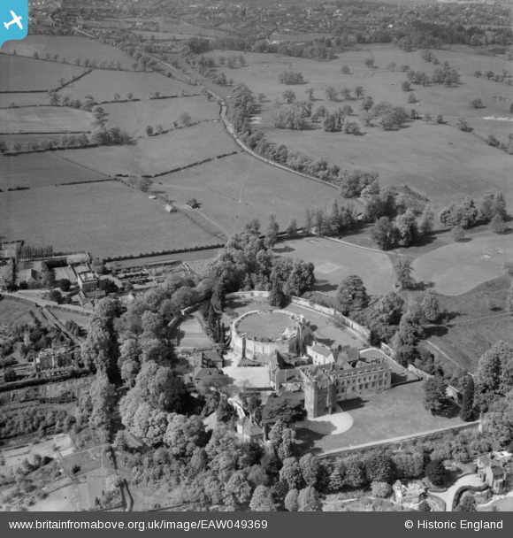
EAW049369 ENGLAND (1953). Farnham Castle and Folly Hill, Farnham, 1953
© Copyright OpenStreetMap contributors and licensed by the OpenStreetMap Foundation. 2025. Cartography is licensed as CC BY-SA.
Nearby Images (19)
Details
| Title | [EAW049369] Farnham Castle and Folly Hill, Farnham, 1953 |
| Reference | EAW049369 |
| Date | May-1953 |
| Link | |
| Place name | FARNHAM |
| Parish | FARNHAM |
| District | |
| Country | ENGLAND |
| Easting / Northing | 483701, 147456 |
| Longitude / Latitude | -0.80136030088961, 51.219642230471 |
| National Grid Reference | SU837475 |
Pins
 Matt Aldred edob.mattaldred.com |
Saturday 5th of December 2020 01:57:54 PM | |
 Matt Aldred edob.mattaldred.com |
Saturday 5th of December 2020 01:57:00 PM | |
 Matt Aldred edob.mattaldred.com |
Saturday 5th of December 2020 01:56:03 PM | |
 Matt Aldred edob.mattaldred.com |
Saturday 5th of December 2020 01:54:47 PM | |
 Matt Aldred edob.mattaldred.com |
Saturday 5th of December 2020 01:53:57 PM | |
 Matt Aldred edob.mattaldred.com |
Saturday 5th of December 2020 01:52:57 PM | |
 Matt Aldred edob.mattaldred.com |
Saturday 5th of December 2020 01:52:42 PM | |
 flubber |
Friday 26th of January 2018 07:42:17 PM | |
 flubber |
Friday 26th of January 2018 07:41:22 PM | |
 Skoyen89 |
Friday 19th of December 2014 02:37:40 PM | |
 Skoyen89 |
Friday 19th of December 2014 02:36:32 PM | |
 Al |
Monday 20th of October 2014 08:49:58 PM | |
 Al |
Monday 20th of October 2014 08:48:15 PM | |
 Al |
Monday 20th of October 2014 08:33:57 PM | |
 Al |
Monday 20th of October 2014 08:33:05 PM | |
 Al |
Monday 20th of October 2014 08:31:02 PM | |
 Al |
Monday 20th of October 2014 08:22:30 PM | |
 jrussill |
Thursday 16th of October 2014 11:51:37 AM | |
previously unrecorded possible T22 approx location at 51°13'41.56"N 0°48'12.89"W (parch marks) |
 Al |
Monday 20th of October 2014 08:40:20 PM |
 jrussill |
Thursday 16th of October 2014 11:50:47 AM | |
S0006982 |
 Al |
Monday 20th of October 2014 08:32:19 PM |
 jrussill |
Thursday 16th of October 2014 11:40:22 AM | |
previously unrecorded T24 / T28 at 51°13'32.39"N 0°48'13.83"W |
 Al |
Monday 20th of October 2014 08:29:20 PM |
 jrussill |
Thursday 16th of October 2014 11:39:57 AM | |
S0009900 |
 Al |
Monday 20th of October 2014 08:24:49 PM |
 jrussill |
Thursday 16th of October 2014 11:39:03 AM | |
S0009899 |
 Al |
Monday 20th of October 2014 08:25:37 PM |
 flubber |
Friday 13th of June 2014 07:54:30 PM | |
 flubber |
Friday 13th of June 2014 07:52:36 PM | |
 flubber |
Friday 13th of June 2014 07:50:53 PM | |
 flubber |
Friday 13th of June 2014 07:50:05 PM | |
 flubber |
Friday 13th of June 2014 07:49:17 PM |
User Comment Contributions
 jrussill |
Thursday 16th of October 2014 11:41:00 AM |


![[EAW049369] Farnham Castle and Folly Hill, Farnham, 1953](http://britainfromabove.org.uk/sites/all/libraries/aerofilms-images/public/100x100/EAW/049/EAW049369.jpg)
![[EAW015545] Farnham Castle, Farnham, 1948. This image has been produced from a print.](http://britainfromabove.org.uk/sites/all/libraries/aerofilms-images/public/100x100/EAW/015/EAW015545.jpg)
![[EAW049368] Farnham Castle, Farnham, 1953](http://britainfromabove.org.uk/sites/all/libraries/aerofilms-images/public/100x100/EAW/049/EAW049368.jpg)
![[EAW049362] Farnham Castle, Farnham, 1953](http://britainfromabove.org.uk/sites/all/libraries/aerofilms-images/public/100x100/EAW/049/EAW049362.jpg)
![[EAW049366] Farnham Castle, Farnham, 1953](http://britainfromabove.org.uk/sites/all/libraries/aerofilms-images/public/100x100/EAW/049/EAW049366.jpg)
![[EAW005206] Farnham Castle, Farnham, 1947. This image has been produced from a print.](http://britainfromabove.org.uk/sites/all/libraries/aerofilms-images/public/100x100/EAW/005/EAW005206.jpg)
![[EPW056809] Farnham Castle, Farnham, 1938](http://britainfromabove.org.uk/sites/all/libraries/aerofilms-images/public/100x100/EPW/056/EPW056809.jpg)
![[EAW015544] Farnham Castle, Farnham, 1948. This image has been produced from a damaged negative.](http://britainfromabove.org.uk/sites/all/libraries/aerofilms-images/public/100x100/EAW/015/EAW015544.jpg)
![[EAW005205] Farnham Castle, Farnham, 1947. This image has been produced from a print.](http://britainfromabove.org.uk/sites/all/libraries/aerofilms-images/public/100x100/EAW/005/EAW005205.jpg)
![[EAW015546] Farnham Castle, Farnham, 1948. This image has been produced from a print.](http://britainfromabove.org.uk/sites/all/libraries/aerofilms-images/public/100x100/EAW/015/EAW015546.jpg)
![[EPW022724] Farnham Castle, Farnham, 1928](http://britainfromabove.org.uk/sites/all/libraries/aerofilms-images/public/100x100/EPW/022/EPW022724.jpg)
![[EPW032701] Farnham Castle, Farnham, 1930](http://britainfromabove.org.uk/sites/all/libraries/aerofilms-images/public/100x100/EPW/032/EPW032701.jpg)
![[EPW022825] Farnham Castle, Farnham, 1928](http://britainfromabove.org.uk/sites/all/libraries/aerofilms-images/public/100x100/EPW/022/EPW022825.jpg)
![[EAW005204] Farnham Castle, Farnham, 1947. This image has been produced from a print.](http://britainfromabove.org.uk/sites/all/libraries/aerofilms-images/public/100x100/EAW/005/EAW005204.jpg)
![[EAW049364] Farnham Castle and the town, Farnham, 1953](http://britainfromabove.org.uk/sites/all/libraries/aerofilms-images/public/100x100/EAW/049/EAW049364.jpg)
![[EAW049365] Farnham Castle, Farnham, 1953](http://britainfromabove.org.uk/sites/all/libraries/aerofilms-images/public/100x100/EAW/049/EAW049365.jpg)
![[EAW049367] Farnham Castle, Farnham, 1953](http://britainfromabove.org.uk/sites/all/libraries/aerofilms-images/public/100x100/EAW/049/EAW049367.jpg)
![[EAW005203] Farnham Castle, Farnham, 1947. This image has been produced from a print.](http://britainfromabove.org.uk/sites/all/libraries/aerofilms-images/public/100x100/EAW/005/EAW005203.jpg)
![[EAW049363] Farnham Castle and the town, Farnham, 1953](http://britainfromabove.org.uk/sites/all/libraries/aerofilms-images/public/100x100/EAW/049/EAW049363.jpg)
