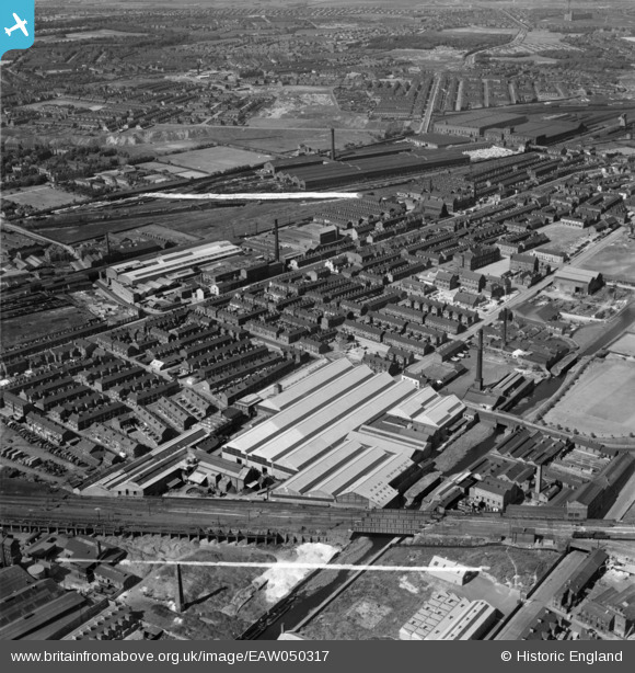
EAW050317 ENGLAND (1953). The R & J Dempster Ltd Gas Plant Works and environs, Newton Heath, 1953. This image was marked by Aerofilms Ltd for photo editing.
© Copyright OpenStreetMap contributors and licensed by the OpenStreetMap Foundation. 2024. Cartography is licensed as CC BY-SA.
Nearby Images (22)
Details
| Title | [EAW050317] The R & J Dempster Ltd Gas Plant Works and environs, Newton Heath, 1953. This image was marked by Aerofilms Ltd for photo editing. |
| Reference | EAW050317 |
| Date | 3-July-1953 |
| Link | |
| Place name | NEWTON HEATH |
| Parish | |
| District | |
| Country | ENGLAND |
| Easting / Northing | 386728, 400126 |
| Longitude / Latitude | -2.2000901322407, 53.497417187453 |
| National Grid Reference | SD867001 |
Pins
 jams39 |
Thursday 25th of November 2021 09:24:04 AM | |
 jams39 |
Thursday 25th of November 2021 09:09:17 AM | |
 jams39 |
Thursday 25th of November 2021 08:39:33 AM | |
 jams39 |
Wednesday 24th of November 2021 06:18:34 PM | |
 jams39 |
Wednesday 24th of November 2021 06:16:00 PM | |
 jams39 |
Wednesday 24th of November 2021 06:10:36 PM | |
 jams39 |
Wednesday 24th of November 2021 06:09:27 PM | |
 John T. Pitman |
Sunday 6th of March 2016 12:57:42 AM |


![[EAW050317] The R & J Dempster Ltd Gas Plant Works and environs, Newton Heath, 1953. This image was marked by Aerofilms Ltd for photo editing.](http://britainfromabove.org.uk/sites/all/libraries/aerofilms-images/public/100x100/EAW/050/EAW050317.jpg)
![[EAW050316] The R & J Dempster Ltd Gas Plant Works and environs, Newton Heath, 1953. This image was marked by Aerofilms Ltd for photo editing.](http://britainfromabove.org.uk/sites/all/libraries/aerofilms-images/public/100x100/EAW/050/EAW050316.jpg)
![[EAW050311] The R & J Dempster Ltd Gas Plant Works and environs, Newton Heath, 1953. This image was marked by Aerofilms Ltd for photo editing.](http://britainfromabove.org.uk/sites/all/libraries/aerofilms-images/public/100x100/EAW/050/EAW050311.jpg)
![[EAW050314] The R & J Dempster Ltd Gas Plant Works and environs, Newton Heath, 1953. This image was marked by Aerofilms Ltd for photo editing.](http://britainfromabove.org.uk/sites/all/libraries/aerofilms-images/public/100x100/EAW/050/EAW050314.jpg)
![[EAW050312] The R & J Dempster Ltd Gas Plant Works and environs, Newton Heath, 1953. This image was marked by Aerofilms Ltd for photo editing.](http://britainfromabove.org.uk/sites/all/libraries/aerofilms-images/public/100x100/EAW/050/EAW050312.jpg)
![[EPW050195] The R and J Dempster Ltd Gas Plant Works, the Rochdale Canal and environs, Newton Heath, 1936](http://britainfromabove.org.uk/sites/all/libraries/aerofilms-images/public/100x100/EPW/050/EPW050195.jpg)
![[EAW050313] The R & J Dempster Ltd Gas Plant Works and environs, Newton Heath, 1953. This image was marked by Aerofilms Ltd for photo editing.](http://britainfromabove.org.uk/sites/all/libraries/aerofilms-images/public/100x100/EAW/050/EAW050313.jpg)
![[EPW050198] The R and J Dempster Ltd Gas Plant Works, Rochdale Canal and environs, Newton Heath, from the south-west, 1936](http://britainfromabove.org.uk/sites/all/libraries/aerofilms-images/public/100x100/EPW/050/EPW050198.jpg)
![[EPW050199] The R and J Dempster Ltd Gas Plant Works and environs, Newton Heath, 1936](http://britainfromabove.org.uk/sites/all/libraries/aerofilms-images/public/100x100/EPW/050/EPW050199.jpg)
![[EPW050191] Ardwick Junction, the R and J Dempster Ltd Gas Plant Works and environs, Newton Heath, 1936](http://britainfromabove.org.uk/sites/all/libraries/aerofilms-images/public/100x100/EPW/050/EPW050191.jpg)
![[EAW050310] The R & J Dempster Ltd Gas Plant Works and environs, Newton Heath, 1953. This image was marked by Aerofilms Ltd for photo editing.](http://britainfromabove.org.uk/sites/all/libraries/aerofilms-images/public/100x100/EAW/050/EAW050310.jpg)
![[EPW050197] The R and J Dempster Ltd Gas Plant Works and environs, Newton Heath, 1936](http://britainfromabove.org.uk/sites/all/libraries/aerofilms-images/public/100x100/EPW/050/EPW050197.jpg)
![[EAW050315] The R & J Dempster Ltd Gas Plant Works and environs, Newton Heath, 1953. This image was marked by Aerofilms Ltd for photo editing.](http://britainfromabove.org.uk/sites/all/libraries/aerofilms-images/public/100x100/EAW/050/EAW050315.jpg)
![[EPW050192] Grimshaw Lane, the R and J Dempster Ltd Gas Plant Works and environs, Newton Heath, 1936](http://britainfromabove.org.uk/sites/all/libraries/aerofilms-images/public/100x100/EPW/050/EPW050192.jpg)
![[EPW050196] The R and J Dempster Ltd Gas Plant Works and environs, Newton Heath, 1936](http://britainfromabove.org.uk/sites/all/libraries/aerofilms-images/public/100x100/EPW/050/EPW050196.jpg)
![[EAW045582] Railway sidings to the south of Newton Heath Brewery, Newton Heath, 1952. This image was marked by Aerofilms Ltd for photo editing.](http://britainfromabove.org.uk/sites/all/libraries/aerofilms-images/public/100x100/EAW/045/EAW045582.jpg)
![[EAW045588] Newton Heath Brewery and environs, Newton Heath, 1952. This image was marked by Aerofilms Ltd for photo editing.](http://britainfromabove.org.uk/sites/all/libraries/aerofilms-images/public/100x100/EAW/045/EAW045588.jpg)
![[EAW045586] Newton Heath Brewery and environs, Newton Heath, 1952. This image was marked by Aerofilms Ltd for photo editing.](http://britainfromabove.org.uk/sites/all/libraries/aerofilms-images/public/100x100/EAW/045/EAW045586.jpg)
![[EPW050193] Ardwick Junction, the R and J Dempster Ltd Gas Plant Works and environs, Newton Heath, from the south-west, 1936](http://britainfromabove.org.uk/sites/all/libraries/aerofilms-images/public/100x100/EPW/050/EPW050193.jpg)
![[EAW045587] Newton Heath Brewery and environs, Newton Heath, 1952. This image was marked by Aerofilms Ltd for photo editing.](http://britainfromabove.org.uk/sites/all/libraries/aerofilms-images/public/100x100/EAW/045/EAW045587.jpg)
![[EAW045585] Newton Heath Brewery and the Newton Heath Ironworks, Harpurhey, 1952. This image was marked by Aerofilms Ltd for photo editing.](http://britainfromabove.org.uk/sites/all/libraries/aerofilms-images/public/100x100/EAW/045/EAW045585.jpg)
![[EAW045580] Newton Heath Brewery, Harpurhey, 1952. This image was marked by Aerofilms Ltd for photo editing.](http://britainfromabove.org.uk/sites/all/libraries/aerofilms-images/public/100x100/EAW/045/EAW045580.jpg)