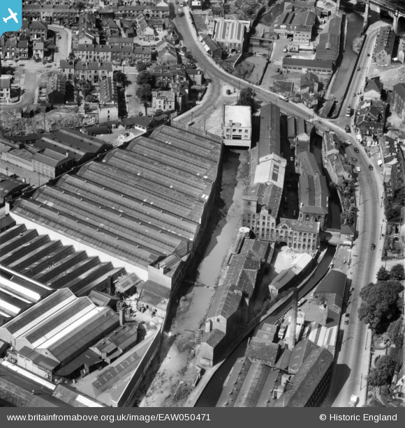
EAW050471 ENGLAND (1953). Springdale Woollen Mills, the River Colne and works off St Thomas' Road, Huddersfield, 1953
© Copyright OpenStreetMap contributors and licensed by the OpenStreetMap Foundation. 2024. Cartography is licensed as CC BY-SA.
Nearby Images (29)
Details
| Title | [EAW050471] Springdale Woollen Mills, the River Colne and works off St Thomas' Road, Huddersfield, 1953 |
| Reference | EAW050471 |
| Date | 8-July-1953 |
| Link | |
| Place name | HUDDERSFIELD |
| Parish | |
| District | |
| Country | ENGLAND |
| Easting / Northing | 413738, 416109 |
| Longitude / Latitude | -1.7921812565412, 53.641081176253 |
| National Grid Reference | SE137161 |
Pins
 John W |
Friday 9th of September 2016 11:42:55 AM | |
 John Wass |
Monday 20th of October 2014 02:07:28 PM |


![[EAW050471] Springdale Woollen Mills, the River Colne and works off St Thomas' Road, Huddersfield, 1953](http://britainfromabove.org.uk/sites/all/libraries/aerofilms-images/public/100x100/EAW/050/EAW050471.jpg)
![[EAW050468] Springdale Woollen Mills and works off St Thomas' Road, Huddersfield, 1953. This image was marked by Aerofilms Ltd for photo editing.](http://britainfromabove.org.uk/sites/all/libraries/aerofilms-images/public/100x100/EAW/050/EAW050468.jpg)
![[EAW050467] Springdale Woollen Mills and works off St Thomas' Road, Huddersfield, 1953. This image was marked by Aerofilms Ltd for photo editing.](http://britainfromabove.org.uk/sites/all/libraries/aerofilms-images/public/100x100/EAW/050/EAW050467.jpg)
![[EAW050466] Springdale Woollen Mills and works off St Thomas' Road, Huddersfield, 1953. This image was marked by Aerofilms Ltd for photo editing.](http://britainfromabove.org.uk/sites/all/libraries/aerofilms-images/public/100x100/EAW/050/EAW050466.jpg)
![[EAW050469] Springdale Woollen Mills and works off St Thomas' Road, Huddersfield, 1953. This image was marked by Aerofilms Ltd for photo editing.](http://britainfromabove.org.uk/sites/all/libraries/aerofilms-images/public/100x100/EAW/050/EAW050469.jpg)
![[EAW050465] Springdale Woollen Mills and works off St Thomas' Road, Huddersfield, 1953. This image was marked by Aerofilms Ltd for photo editing.](http://britainfromabove.org.uk/sites/all/libraries/aerofilms-images/public/100x100/EAW/050/EAW050465.jpg)
![[EAW050472] Springdale Woollen Mills and environs, Huddersfield, 1953](http://britainfromabove.org.uk/sites/all/libraries/aerofilms-images/public/100x100/EAW/050/EAW050472.jpg)
![[EAW050470] Springdale Woollen Mills, Manchester Road and environs, Huddersfield, 1953. This image was marked by Aerofilms Ltd for photo editing.](http://britainfromabove.org.uk/sites/all/libraries/aerofilms-images/public/100x100/EAW/050/EAW050470.jpg)
![[EAW047445] Springdale Woollen Mills and works off St Thomas' Road, Huddersfield, 1952. This image was marked by Aerofilms Ltd for photo editing.](http://britainfromabove.org.uk/sites/all/libraries/aerofilms-images/public/100x100/EAW/047/EAW047445.jpg)
![[EAW047440] Springdale Woollen Mills, Springwood Junction and works off St Thomas' Road, Huddersfield, 1952. This image was marked by Aerofilms Ltd for photo editing.](http://britainfromabove.org.uk/sites/all/libraries/aerofilms-images/public/100x100/EAW/047/EAW047440.jpg)
![[EAW047442] Springdale Woollen Mills and works off St Thomas' Road, Huddersfield, 1952. This image was marked by Aerofilms Ltd for photo editing.](http://britainfromabove.org.uk/sites/all/libraries/aerofilms-images/public/100x100/EAW/047/EAW047442.jpg)
![[EAW047738] The Springdale Woollen Mills, St Thomas' Church and the surrounding industrial area, Huddersfield, 1952. This image was marked by Aerofilms Ltd for photo editing.](http://britainfromabove.org.uk/sites/all/libraries/aerofilms-images/public/100x100/EAW/047/EAW047738.jpg)
![[EAW047742] The Springdale Woollen Mills, St Thomas' Road and the surrounding industrial area, Huddersfield, 1952. This image was marked by Aerofilms Ltd for photo editing.](http://britainfromabove.org.uk/sites/all/libraries/aerofilms-images/public/100x100/EAW/047/EAW047742.jpg)
![[EAW047740] The Springdale Woollen Mills, St Thomas' Road and the surrounding industrial area, Huddersfield, 1952. This image was marked by Aerofilms Ltd for photo editing.](http://britainfromabove.org.uk/sites/all/libraries/aerofilms-images/public/100x100/EAW/047/EAW047740.jpg)
![[EAW047746] The Springdale Woollen Mills, St Thomas' Road and the surrounding industrial area, Huddersfield, 1952. This image was marked by Aerofilms Ltd for photo editing.](http://britainfromabove.org.uk/sites/all/libraries/aerofilms-images/public/100x100/EAW/047/EAW047746.jpg)
![[EAW047443] Springdale Woollen Mills, Manchester Road and works off St Thomas' Road, Huddersfield, 1952. This image was marked by Aerofilms Ltd for photo editing.](http://britainfromabove.org.uk/sites/all/libraries/aerofilms-images/public/100x100/EAW/047/EAW047443.jpg)
![[EAW047444] Springdale Woollen Mills, works off St Thomas' Road and the Paddock Viaduct, Huddersfield, 1952. This image was marked by Aerofilms Ltd for photo editing.](http://britainfromabove.org.uk/sites/all/libraries/aerofilms-images/public/100x100/EAW/047/EAW047444.jpg)
![[EAW047741] The Springdale Woollen Mills and environs, Huddersfield, 1952. This image was marked by Aerofilms Ltd for photo editing.](http://britainfromabove.org.uk/sites/all/libraries/aerofilms-images/public/100x100/EAW/047/EAW047741.jpg)
![[EAW047441] Springdale Woollen Mills and works off St Thomas' Road, Huddersfield, 1952](http://britainfromabove.org.uk/sites/all/libraries/aerofilms-images/public/100x100/EAW/047/EAW047441.jpg)
![[EAW047743] The Springdale Woollen Mills and environs, Huddersfield, 1952. This image was marked by Aerofilms Ltd for photo editing.](http://britainfromabove.org.uk/sites/all/libraries/aerofilms-images/public/100x100/EAW/047/EAW047743.jpg)
![[EAW047744] The Springdale Woollen Mills, St Thomas' Church and the surrounding area, Huddersfield, 1952. This image was marked by Aerofilms Ltd for photo editing.](http://britainfromabove.org.uk/sites/all/libraries/aerofilms-images/public/100x100/EAW/047/EAW047744.jpg)
![[EAW047447] Springdale Woollen Mills and works off St Thomas' Road, Huddersfield, 1952. This image was marked by Aerofilms Ltd for photo editing.](http://britainfromabove.org.uk/sites/all/libraries/aerofilms-images/public/100x100/EAW/047/EAW047447.jpg)
![[EAW047739] The Springdale Woollen Mills, St Thomas' Church and the surrounding industrial area, Huddersfield, 1952. This image was marked by Aerofilms Ltd for photo editing.](http://britainfromabove.org.uk/sites/all/libraries/aerofilms-images/public/100x100/EAW/047/EAW047739.jpg)
![[EAW047446] Springdale Woollen Mills and works off St Thomas' Road, Huddersfield, 1952. This image was marked by Aerofilms Ltd for photo editing.](http://britainfromabove.org.uk/sites/all/libraries/aerofilms-images/public/100x100/EAW/047/EAW047446.jpg)
![[EAW047439] Springdale Woollen Mills, the Paddock Viaduct and environs, Huddersfield, 1952. This image was marked by Aerofilms Ltd for photo editing.](http://britainfromabove.org.uk/sites/all/libraries/aerofilms-images/public/100x100/EAW/047/EAW047439.jpg)
![[EAW047737] The Springdale Woollen Mills, St Thomas' Church and the surrounding area, Huddersfield, 1952. This image was marked by Aerofilms Ltd for photo editing.](http://britainfromabove.org.uk/sites/all/libraries/aerofilms-images/public/100x100/EAW/047/EAW047737.jpg)
![[EAW047745] The Springdale Woollen Mills, St Thomas' Road and the surrounding industrial area, Huddersfield, 1952. This image was marked by Aerofilms Ltd for photo editing.](http://britainfromabove.org.uk/sites/all/libraries/aerofilms-images/public/100x100/EAW/047/EAW047745.jpg)
![[EAW020163] Cliffe and Co Ltd Longroyd Bridge Iron Works and environs, Huddersfield, 1948. This image has been produced from a print marked by Aerofilms Ltd for photo editing.](http://britainfromabove.org.uk/sites/all/libraries/aerofilms-images/public/100x100/EAW/020/EAW020163.jpg)
![[EAW020164] Cliffe and Co Ltd Longroyd Bridge Iron Works and environs, Huddersfield, 1948. This image has been produced from a print marked by Aerofilms Ltd for photo editing.](http://britainfromabove.org.uk/sites/all/libraries/aerofilms-images/public/100x100/EAW/020/EAW020164.jpg)