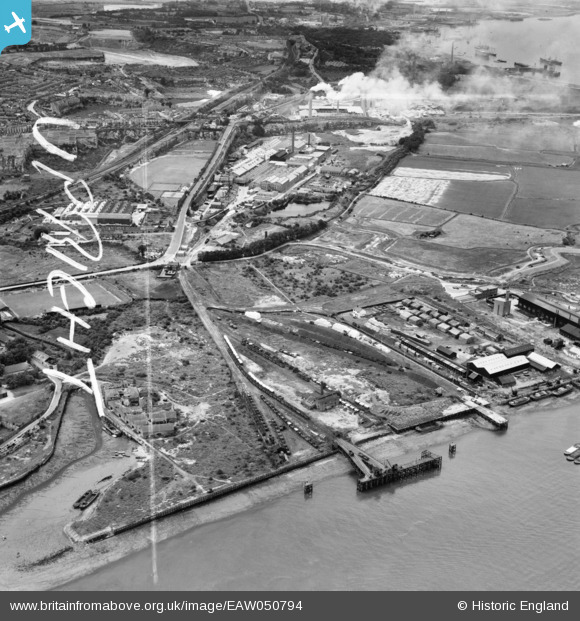
EAW050794 ENGLAND (1953). The Deep Water Pier, Tower Wharf, London Road and environs, Northfleet, 1953. This image was marked by Aerofilms Ltd for photo editing.
© Copyright OpenStreetMap contributors and licensed by the OpenStreetMap Foundation. 2025. Cartography is licensed as CC BY-SA.
Nearby Images (27)
Details
| Title | [EAW050794] The Deep Water Pier, Tower Wharf, London Road and environs, Northfleet, 1953. This image was marked by Aerofilms Ltd for photo editing. |
| Reference | EAW050794 |
| Date | 21-July-1953 |
| Link | |
| Place name | NORTHFLEET |
| Parish | |
| District | |
| Country | ENGLAND |
| Easting / Northing | 561396, 175082 |
| Longitude / Latitude | 0.3230486790894, 51.451197382565 |
| National Grid Reference | TQ614751 |
Pins
 Dylan Moore |
Monday 17th of November 2014 05:10:08 PM | |
 Dylan Moore |
Monday 17th of November 2014 05:09:25 PM | |
 Dylan Moore |
Monday 17th of November 2014 05:08:49 PM | |
 Dylan Moore |
Monday 17th of November 2014 05:08:01 PM | |
 Dylan Moore |
Monday 17th of November 2014 05:06:07 PM |


![[EAW050794] The Deep Water Pier, Tower Wharf, London Road and environs, Northfleet, 1953. This image was marked by Aerofilms Ltd for photo editing.](http://britainfromabove.org.uk/sites/all/libraries/aerofilms-images/public/100x100/EAW/050/EAW050794.jpg)
![[EPW040726] The Tower Concrete Blocks Works and the Deep Water Pier, Northfleet, 1932](http://britainfromabove.org.uk/sites/all/libraries/aerofilms-images/public/100x100/EPW/040/EPW040726.jpg)
![[EPW040727] The Tower Concrete Blocks Works and the Deep Water Pier, Northfleet, 1932](http://britainfromabove.org.uk/sites/all/libraries/aerofilms-images/public/100x100/EPW/040/EPW040727.jpg)
![[EPW040729] The Tower Concrete Blocks Works, Northfleet, 1932](http://britainfromabove.org.uk/sites/all/libraries/aerofilms-images/public/100x100/EPW/040/EPW040729.jpg)
![[EAW050795] The Deep Water Pier, Tower Wharf, London Road and environs, Northfleet, 1953. This image was marked by Aerofilms Ltd for photo editing.](http://britainfromabove.org.uk/sites/all/libraries/aerofilms-images/public/100x100/EAW/050/EAW050795.jpg)
![[EPW028497] The Deep Water Pier and tramway system serving the paper mills, Northfleet, 1929](http://britainfromabove.org.uk/sites/all/libraries/aerofilms-images/public/100x100/EPW/028/EPW028497.jpg)
![[EAW042587] Baxter Fell and Co Ltd Works at Tower Wharf, Northfleet, 1952. This image was marked by Aerofilms Ltd for photo editing.](http://britainfromabove.org.uk/sites/all/libraries/aerofilms-images/public/100x100/EAW/042/EAW042587.jpg)
![[EPW040728] The Tower Concrete Blocks Works and the Deep Water Pier, Northfleet, 1932](http://britainfromabove.org.uk/sites/all/libraries/aerofilms-images/public/100x100/EPW/040/EPW040728.jpg)
![[EAW042588] Baxter Fell and Co Ltd Works at Tower Wharf, Northfleet, 1952. This image was marked by Aerofilms Ltd for photo editing.](http://britainfromabove.org.uk/sites/all/libraries/aerofilms-images/public/100x100/EAW/042/EAW042588.jpg)
![[EAW042591] Baxter Fell and Co Ltd Works at Tower Wharf, Northfleet, 1952. This image was marked by Aerofilms Ltd for photo editing.](http://britainfromabove.org.uk/sites/all/libraries/aerofilms-images/public/100x100/EAW/042/EAW042591.jpg)
![[EAW042583] Baxter Fell and Co Ltd Works at Tower Wharf, Northfleet, 1952. This image was marked by Aerofilms Ltd for photo editing.](http://britainfromabove.org.uk/sites/all/libraries/aerofilms-images/public/100x100/EAW/042/EAW042583.jpg)
![[EPW028499] The Tower Concrete Blocks Works, the Deep Water Pier and tramway system serving the paper mills, Northfleet, 1929](http://britainfromabove.org.uk/sites/all/libraries/aerofilms-images/public/100x100/EPW/028/EPW028499.jpg)
![[EAW042577] Baxter Fell and Co Ltd Works at Tower Wharf, Northfleet, 1952. This image was marked by Aerofilms Ltd for photo editing.](http://britainfromabove.org.uk/sites/all/libraries/aerofilms-images/public/100x100/EAW/042/EAW042577.jpg)
![[EAW042585] Baxter Fell and Co Ltd Works at Tower Wharf, Northfleet, 1952](http://britainfromabove.org.uk/sites/all/libraries/aerofilms-images/public/100x100/EAW/042/EAW042585.jpg)
![[EAW042590] Baxter Fell and Co Ltd Works at Tower Wharf, Northfleet, 1952. This image was marked by Aerofilms Ltd for photo editing.](http://britainfromabove.org.uk/sites/all/libraries/aerofilms-images/public/100x100/EAW/042/EAW042590.jpg)
![[EPW040736] The Tower Concrete Blocks Works, Northfleet, 1932](http://britainfromabove.org.uk/sites/all/libraries/aerofilms-images/public/100x100/EPW/040/EPW040736.jpg)
![[EAW042580] Baxter Fell and Co Ltd Works at Tower Wharf, Northfleet, 1952. This image was marked by Aerofilms Ltd for photo editing.](http://britainfromabove.org.uk/sites/all/libraries/aerofilms-images/public/100x100/EAW/042/EAW042580.jpg)
![[EAW042589] Baxter Fell and Co Ltd Works at Tower Wharf, Northfleet, 1952. This image was marked by Aerofilms Ltd for photo editing.](http://britainfromabove.org.uk/sites/all/libraries/aerofilms-images/public/100x100/EAW/042/EAW042589.jpg)
![[EPW028500] The Tower Concrete Blocks Works, the Deep Water Pier and tramway system serving the paper mills, Northfleet, 1929](http://britainfromabove.org.uk/sites/all/libraries/aerofilms-images/public/100x100/EPW/028/EPW028500.jpg)
![[EAW042586] Baxter Fell and Co Ltd Works at Tower Wharf, Northfleet, 1952. This image was marked by Aerofilms Ltd for photo editing.](http://britainfromabove.org.uk/sites/all/libraries/aerofilms-images/public/100x100/EAW/042/EAW042586.jpg)
![[EAW042579] Baxter Fell and Co Ltd Works at Tower Wharf, Northfleet, 1952](http://britainfromabove.org.uk/sites/all/libraries/aerofilms-images/public/100x100/EAW/042/EAW042579.jpg)
![[EAW042582] Baxter Fell and Co Ltd Works at Tower Wharf, Northfleet, 1952. This image was marked by Aerofilms Ltd for photo editing.](http://britainfromabove.org.uk/sites/all/libraries/aerofilms-images/public/100x100/EAW/042/EAW042582.jpg)
![[EAW042584] Baxter Fell and Co Ltd Works at Tower Wharf, Northfleet, 1952. This image was marked by Aerofilms Ltd for photo editing.](http://britainfromabove.org.uk/sites/all/libraries/aerofilms-images/public/100x100/EAW/042/EAW042584.jpg)
![[EAW042581] Baxter Fell and Co Ltd Works at Tower Wharf, Northfleet, 1952. This image was marked by Aerofilms Ltd for photo editing.](http://britainfromabove.org.uk/sites/all/libraries/aerofilms-images/public/100x100/EAW/042/EAW042581.jpg)
![[EPW040735] The Britannia Lead Works and Tower Concrete Blocks Works, Northfleet, 1932](http://britainfromabove.org.uk/sites/all/libraries/aerofilms-images/public/100x100/EPW/040/EPW040735.jpg)
![[EAW042578] Baxter Fell and Co Ltd Works at Tower Wharf, Northfleet, 1952](http://britainfromabove.org.uk/sites/all/libraries/aerofilms-images/public/100x100/EAW/042/EAW042578.jpg)
![[EPW040953] The Britannia Lead Works and the Tower Cement Works alongside the River Thames, Northfleet, from the west, 1933](http://britainfromabove.org.uk/sites/all/libraries/aerofilms-images/public/100x100/EPW/040/EPW040953.jpg)