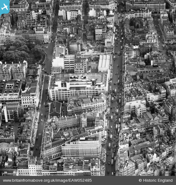
EAW052485 ENGLAND (1953). Oxford Street west of Oxford Circus, Westminster, 1953
© Copyright OpenStreetMap contributors and licensed by the OpenStreetMap Foundation. 2025. Cartography is licensed as CC BY-SA.
Nearby Images (27)
Details
| Title | [EAW052485] Oxford Street west of Oxford Circus, Westminster, 1953 |
| Reference | EAW052485 |
| Date | 30-September-1953 |
| Link | |
| Place name | WESTMINSTER |
| Parish | |
| District | |
| Country | ENGLAND |
| Easting / Northing | 528699, 181211 |
| Longitude / Latitude | -0.14504189905914, 51.514662048123 |
| National Grid Reference | TQ287812 |
Pins
Be the first to add a comment to this image!


![[EAW052485] Oxford Street west of Oxford Circus, Westminster, 1953](http://britainfromabove.org.uk/sites/all/libraries/aerofilms-images/public/100x100/EAW/052/EAW052485.jpg)
![[EAW050865] Oxford Street including John Lewis Department Store and Cavendish Square, Westminster, 1953](http://britainfromabove.org.uk/sites/all/libraries/aerofilms-images/public/100x100/EAW/050/EAW050865.jpg)
![[EAW050866] Oxford Street from Marylebone Lane to Hollies Street, Westminster, 1953](http://britainfromabove.org.uk/sites/all/libraries/aerofilms-images/public/100x100/EAW/050/EAW050866.jpg)
![[EAW050843] Oxford Street including John Lewis and D H Evans Department Stores, Westminster, 1953](http://britainfromabove.org.uk/sites/all/libraries/aerofilms-images/public/100x100/EAW/050/EAW050843.jpg)
![[EAW050859] Oxford Street including John Lewis Department Store, Westminster, 1953](http://britainfromabove.org.uk/sites/all/libraries/aerofilms-images/public/100x100/EAW/050/EAW050859.jpg)
![[EAW030115] Oxford Street and environs, Mayfair, 1950](http://britainfromabove.org.uk/sites/all/libraries/aerofilms-images/public/100x100/EAW/030/EAW030115.jpg)
![[EPW006304] View of Oxford Street and environs, Westminster, from the west, 1921](http://britainfromabove.org.uk/sites/all/libraries/aerofilms-images/public/100x100/EPW/006/EPW006304.jpg)
![[EAW052486] Oxford Street west of Oxford Circus, Westminster, 1953](http://britainfromabove.org.uk/sites/all/libraries/aerofilms-images/public/100x100/EAW/052/EAW052486.jpg)
![[EPW060758] Oxford Street and the surrounding streets, Marylebone, 1939](http://britainfromabove.org.uk/sites/all/libraries/aerofilms-images/public/100x100/EPW/060/EPW060758.jpg)
![[EAW050840] Oxford Street including John Lewis Department Store, Westminster, 1953](http://britainfromabove.org.uk/sites/all/libraries/aerofilms-images/public/100x100/EAW/050/EAW050840.jpg)
![[EAW000559] Regent Street, Cavendish Square and environs, Westminster, 1946](http://britainfromabove.org.uk/sites/all/libraries/aerofilms-images/public/100x100/EAW/000/EAW000559.jpg)
![[EAW050856] Oxford Street and Hollies Street including John Lewis Department Store, Westminster, 1953](http://britainfromabove.org.uk/sites/all/libraries/aerofilms-images/public/100x100/EAW/050/EAW050856.jpg)
![[EPW021443] Oxford Circus and Oxford Street, Marylebone, from the west, 1928](http://britainfromabove.org.uk/sites/all/libraries/aerofilms-images/public/100x100/EPW/021/EPW021443.jpg)
![[EAW050836] Oxford Circus and Oxford Street, Westminster, 1953](http://britainfromabove.org.uk/sites/all/libraries/aerofilms-images/public/100x100/EAW/050/EAW050836.jpg)
![[EPW021404] Regent's Street and environs, Soho, from the north-west, 1928](http://britainfromabove.org.uk/sites/all/libraries/aerofilms-images/public/100x100/EPW/021/EPW021404.jpg)
![[EPW021934] Hanover Square and Oxford Circus, Westminster, 1928](http://britainfromabove.org.uk/sites/all/libraries/aerofilms-images/public/100x100/EPW/021/EPW021934.jpg)
![[EAW050838] Oxford Street and Oxford Circus, Westminster, 1953](http://britainfromabove.org.uk/sites/all/libraries/aerofilms-images/public/100x100/EAW/050/EAW050838.jpg)
![[EAW052487] Oxford Street at Oxford Circus, Westminster, 1953](http://britainfromabove.org.uk/sites/all/libraries/aerofilms-images/public/100x100/EAW/052/EAW052487.jpg)
![[EPW047237] A London cityscape featuring Grosvenor Square, Marylebone, 1935](http://britainfromabove.org.uk/sites/all/libraries/aerofilms-images/public/100x100/EPW/047/EPW047237.jpg)
![[EAW052488] Oxford Street at Oxford Circus, Westminster, 1953](http://britainfromabove.org.uk/sites/all/libraries/aerofilms-images/public/100x100/EAW/052/EAW052488.jpg)
![[EAW050839] Oxford Street, Westminster, 1953](http://britainfromabove.org.uk/sites/all/libraries/aerofilms-images/public/100x100/EAW/050/EAW050839.jpg)
![[EPW045398] Oxford Circus and environs, Marylebone, 1934](http://britainfromabove.org.uk/sites/all/libraries/aerofilms-images/public/100x100/EPW/045/EPW045398.jpg)
![[EAW000563] Marylebone High Street and environs, Marylebone, from the south-east, 1946](http://britainfromabove.org.uk/sites/all/libraries/aerofilms-images/public/100x100/EAW/000/EAW000563.jpg)
![[EAW000560] Regent Street, Cavendish Square, Oxford Circus and environs, Westminster, 1946](http://britainfromabove.org.uk/sites/all/libraries/aerofilms-images/public/100x100/EAW/000/EAW000560.jpg)
![[EPW053003] A cityscape of Oxford Street running from Soho to Hyde Park, Mayfair, 1937](http://britainfromabove.org.uk/sites/all/libraries/aerofilms-images/public/100x100/EPW/053/EPW053003.jpg)
![[EPW059412] A cityscape from Marble Arch along Oxford Street, Westminster, 1938](http://britainfromabove.org.uk/sites/all/libraries/aerofilms-images/public/100x100/EPW/059/EPW059412.jpg)
![[EAW041946] Regent Street by Cavendish Square, Marylebone, 1952](http://britainfromabove.org.uk/sites/all/libraries/aerofilms-images/public/100x100/EAW/041/EAW041946.jpg)