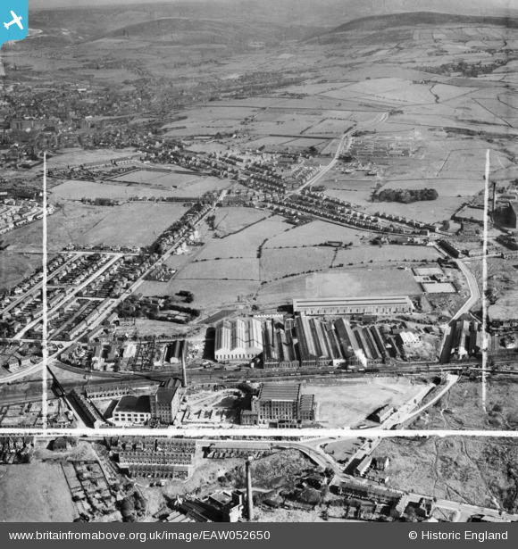
EAW052650 ENGLAND (1953). The Daniel Adamson and Co Ltd Engineering Works and environs, Dukinfield, 1953. This image was marked by Aerofilms Ltd for photo editing.
© Copyright OpenStreetMap contributors and licensed by the OpenStreetMap Foundation. 2025. Cartography is licensed as CC BY-SA.
Nearby Images (27)
Details
| Title | [EAW052650] The Daniel Adamson and Co Ltd Engineering Works and environs, Dukinfield, 1953. This image was marked by Aerofilms Ltd for photo editing. |
| Reference | EAW052650 |
| Date | 5-October-1953 |
| Link | |
| Place name | DUKINFIELD |
| Parish | |
| District | |
| Country | ENGLAND |
| Easting / Northing | 394701, 396845 |
| Longitude / Latitude | -2.0798331407985, 53.468063471716 |
| National Grid Reference | SJ947968 |
Pins
 Globe Lane Pals |
Sunday 13th of September 2015 09:47:45 PM | |
 Globe Lane Pals |
Sunday 13th of September 2015 09:45:22 PM | |
 Globe Lane Pals |
Sunday 13th of September 2015 09:43:31 PM | |
 Globe Lane Pals |
Sunday 13th of September 2015 09:32:11 PM | |
 John Wass |
Friday 15th of May 2015 09:15:10 PM | |
Correct, the train is the local mixed stopping freight which visited most sidings along the line to Maccelsfield and Hayfield. Its main delivery was coal to the many coal merchants based along the line. |
 Globe Lane Pals |
Sunday 13th of September 2015 09:37:27 PM |


![[EAW052650] The Daniel Adamson and Co Ltd Engineering Works and environs, Dukinfield, 1953. This image was marked by Aerofilms Ltd for photo editing.](http://britainfromabove.org.uk/sites/all/libraries/aerofilms-images/public/100x100/EAW/052/EAW052650.jpg)
![[EAW037555] The Daniel Adamson & Co Ltd Engineering Works and environs, Dukinfield, 1951. This image has been produced from a print marked by Aerofilms Ltd for photo editing.](http://britainfromabove.org.uk/sites/all/libraries/aerofilms-images/public/100x100/EAW/037/EAW037555.jpg)
![[EAW052652] The Daniel Adamson and Co Ltd Engineering Works and environs, Dukinfield, 1953. This image was marked by Aerofilms Ltd for photo editing.](http://britainfromabove.org.uk/sites/all/libraries/aerofilms-images/public/100x100/EAW/052/EAW052652.jpg)
![[EAW037554] The Daniel Adamson & Co Ltd Engineering Works and environs, Dukinfield, 1951. This image has been produced from a print marked by Aerofilms Ltd for photo editing.](http://britainfromabove.org.uk/sites/all/libraries/aerofilms-images/public/100x100/EAW/037/EAW037554.jpg)
![[EAW052651] The Daniel Adamson and Co Ltd Engineering Works and environs, Dukinfield, 1953. This image was marked by Aerofilms Ltd for photo editing.](http://britainfromabove.org.uk/sites/all/libraries/aerofilms-images/public/100x100/EAW/052/EAW052651.jpg)
![[EAW026612] The Daniel Adamson & Co Ltd Engineering Works and environs, Dukinfield, 1949. This image has been produced from a print marked by Aerofilms Ltd for photo editing.](http://britainfromabove.org.uk/sites/all/libraries/aerofilms-images/public/100x100/EAW/026/EAW026612.jpg)
![[EAW052653] The Daniel Adamson and Co Ltd Engineering Works and environs, Dukinfield, 1953. This image was marked by Aerofilms Ltd for photo editing.](http://britainfromabove.org.uk/sites/all/libraries/aerofilms-images/public/100x100/EAW/052/EAW052653.jpg)
![[EAW037553] The Daniel Adamson & Co Ltd Engineering Works, Dukinfield, 1951. This image has been produced from a print marked by Aerofilms Ltd for photo editing.](http://britainfromabove.org.uk/sites/all/libraries/aerofilms-images/public/100x100/EAW/037/EAW037553.jpg)
![[EAW008498] The Daniel Adamson and Co Engineering Works, Dukinfield, 1947. This image was marked by Aerofilms Ltd for photo editing.](http://britainfromabove.org.uk/sites/all/libraries/aerofilms-images/public/100x100/EAW/008/EAW008498.jpg)
![[EAW008502] The Daniel Adamson and Co Engineering Works, Dukinfield, 1947. This image was marked by Aerofilms Ltd for photo editing.](http://britainfromabove.org.uk/sites/all/libraries/aerofilms-images/public/100x100/EAW/008/EAW008502.jpg)
![[EAW026615] The Daniel Adamson & Co Ltd Engineering Works and environs, Dukinfield, 1949. This image has been produced from a damaged negative.](http://britainfromabove.org.uk/sites/all/libraries/aerofilms-images/public/100x100/EAW/026/EAW026615.jpg)
![[EAW052647] The Daniel Adamson and Co Ltd Engineering Works, Dukinfield, 1953. This image was marked by Aerofilms Ltd for photo editing.](http://britainfromabove.org.uk/sites/all/libraries/aerofilms-images/public/100x100/EAW/052/EAW052647.jpg)
![[EAW008499] The Daniel Adamson and Co Engineering Works, Dukinfield, 1947. This image was marked by Aerofilms Ltd for photo editing.](http://britainfromabove.org.uk/sites/all/libraries/aerofilms-images/public/100x100/EAW/008/EAW008499.jpg)
![[EAW037549] The Daniel Adamson & Co Ltd Engineering Works, Dukinfield, 1951. This image has been produced from a print marked by Aerofilms Ltd for photo editing.](http://britainfromabove.org.uk/sites/all/libraries/aerofilms-images/public/100x100/EAW/037/EAW037549.jpg)
![[EAW037547] The Daniel Adamson & Co Ltd Engineering Works, Dukinfield, 1951. This image has been produced from a print marked by Aerofilms Ltd for photo editing.](http://britainfromabove.org.uk/sites/all/libraries/aerofilms-images/public/100x100/EAW/037/EAW037547.jpg)
![[EAW037550] The Daniel Adamson & Co Ltd Engineering Works, Dukinfield, 1951. This image has been produced from a print marked by Aerofilms Ltd for photo editing.](http://britainfromabove.org.uk/sites/all/libraries/aerofilms-images/public/100x100/EAW/037/EAW037550.jpg)
![[EAW052649] The Daniel Adamson and Co Ltd Engineering Works, Dukinfield, 1953. This image was marked by Aerofilms Ltd for photo editing.](http://britainfromabove.org.uk/sites/all/libraries/aerofilms-images/public/100x100/EAW/052/EAW052649.jpg)
![[EAW026614] The Daniel Adamson & Co Ltd Engineering Works (site of), Dukinfield, 1949. This image has been produced from a damaged negative.](http://britainfromabove.org.uk/sites/all/libraries/aerofilms-images/public/100x100/EAW/026/EAW026614.jpg)
![[EAW026611] The Daniel Adamson & Co Ltd Engineering Works, Dukinfield, 1949. This image has been produced from a print marked by Aerofilms Ltd for photo editing.](http://britainfromabove.org.uk/sites/all/libraries/aerofilms-images/public/100x100/EAW/026/EAW026611.jpg)
![[EAW037545] The Daniel Adamson & Co Ltd Engineering Works, Dukinfield, 1951. This image has been produced from a print marked by Aerofilms Ltd for photo editing.](http://britainfromabove.org.uk/sites/all/libraries/aerofilms-images/public/100x100/EAW/037/EAW037545.jpg)
![[EAW008501] The Daniel Adamson and Co Engineering Works, Dukinfield, 1947. This image was marked by Aerofilms Ltd for photo editing.](http://britainfromabove.org.uk/sites/all/libraries/aerofilms-images/public/100x100/EAW/008/EAW008501.jpg)
![[EAW026616] The Daniel Adamson & Co Ltd Engineering Works and environs, Dukinfield, 1949. This image was marked by Aerofilms Ltd for photo editing.](http://britainfromabove.org.uk/sites/all/libraries/aerofilms-images/public/100x100/EAW/026/EAW026616.jpg)
![[EAW037548] The Daniel Adamson & Co Ltd Engineering Works, Dukinfield, 1951. This image has been produced from a print marked by Aerofilms Ltd for photo editing.](http://britainfromabove.org.uk/sites/all/libraries/aerofilms-images/public/100x100/EAW/037/EAW037548.jpg)
![[EAW052646] The Daniel Adamson and Co Ltd Engineering Works, Dukinfield, 1953. This image was marked by Aerofilms Ltd for photo editing.](http://britainfromabove.org.uk/sites/all/libraries/aerofilms-images/public/100x100/EAW/052/EAW052646.jpg)
![[EAW026617] The Daniel Adamson & Co Ltd Engineering Works and environs, Dukinfield, 1949. This image was marked by Aerofilms Ltd for photo editing.](http://britainfromabove.org.uk/sites/all/libraries/aerofilms-images/public/100x100/EAW/026/EAW026617.jpg)
![[EAW037544] The Daniel Adamson & Co Ltd Engineering Works, Dukinfield, 1951. This image has been produced from a print marked by Aerofilms Ltd for photo editing.](http://britainfromabove.org.uk/sites/all/libraries/aerofilms-images/public/100x100/EAW/037/EAW037544.jpg)
![[EAW026619] The Daniel Adamson & Co Ltd Engineering Works and environs, Dukinfield, 1949. This image was marked by Aerofilms Ltd for photo editing.](http://britainfromabove.org.uk/sites/all/libraries/aerofilms-images/public/100x100/EAW/026/EAW026619.jpg)