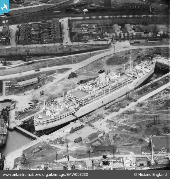
EAW053230 ENGLAND (1954). The RMS Orion in Dry Dock, Tilbury, 1954
© Copyright OpenStreetMap contributors and licensed by the OpenStreetMap Foundation. 2024. Cartography is licensed as CC BY-SA.
Nearby Images (10)
Details
| Title | [EAW053230] The RMS Orion in Dry Dock, Tilbury, 1954 |
| Reference | EAW053230 |
| Date | 17-March-1954 |
| Link | |
| Place name | TILBURY |
| Parish | |
| District | |
| Country | ENGLAND |
| Easting / Northing | 564031, 175620 |
| Longitude / Latitude | 0.36119063390985, 51.455274000885 |
| National Grid Reference | TQ640756 |
Pins
 rivermersey |
Saturday 28th of September 2024 09:55:16 PM |


![[EAW053230] The RMS Orion in Dry Dock, Tilbury, 1954](http://britainfromabove.org.uk/sites/all/libraries/aerofilms-images/public/100x100/EAW/053/EAW053230.jpg)
![[EAW053227] The RMS Orion in Dry Dock, Tilbury, 1954](http://britainfromabove.org.uk/sites/all/libraries/aerofilms-images/public/100x100/EAW/053/EAW053227.jpg)
![[EAW053228] The RMS Orion in Dry Dock, Tilbury, 1954](http://britainfromabove.org.uk/sites/all/libraries/aerofilms-images/public/100x100/EAW/053/EAW053228.jpg)
![[EAW053226] The RMS Orion in Dry Dock, Tilbury, 1954](http://britainfromabove.org.uk/sites/all/libraries/aerofilms-images/public/100x100/EAW/053/EAW053226.jpg)
![[EPW032815] The Dry Docks, Tilbury, 1930](http://britainfromabove.org.uk/sites/all/libraries/aerofilms-images/public/100x100/EPW/032/EPW032815.jpg)
![[EAW053229] The RMS Orion in Dry Dock, Tilbury, 1954](http://britainfromabove.org.uk/sites/all/libraries/aerofilms-images/public/100x100/EAW/053/EAW053229.jpg)
![[EAR036175] Dry dock, Tilbury, Essex, 1959](http://britainfromabove.org.uk/sites/all/libraries/aerofilms-images/public/100x100/EAR/036/EAR036175.jpg)
![[EAW053225] The RMS Orion in Dry Dock, Tilbury, 1954](http://britainfromabove.org.uk/sites/all/libraries/aerofilms-images/public/100x100/EAW/053/EAW053225.jpg)
![[EPW032813] The Dry Docks, Tilbury, 1930](http://britainfromabove.org.uk/sites/all/libraries/aerofilms-images/public/100x100/EPW/032/EPW032813.jpg)
![[EPW032814] The Dry Docks, Tilbury, 1930](http://britainfromabove.org.uk/sites/all/libraries/aerofilms-images/public/100x100/EPW/032/EPW032814.jpg)