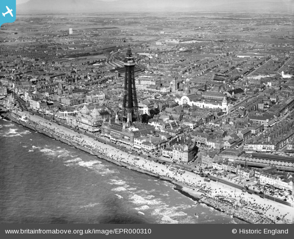
EPR000310 ENGLAND (1934). The Tower and the town, Blackpool, from the south-west, 1934
© Copyright OpenStreetMap contributors and licensed by the OpenStreetMap Foundation. 2025. Cartography is licensed as CC BY-SA.
Nearby Images (19)
Details
| Title | [EPR000310] The Tower and the town, Blackpool, from the south-west, 1934 |
| Reference | EPR000310 |
| Date | 30-August-1934 |
| Link | |
| Place name | BLACKPOOL |
| Parish | |
| District | |
| Country | ENGLAND |
| Easting / Northing | 330577, 435937 |
| Longitude / Latitude | -3.0545387404055, 53.814862389676 |
| National Grid Reference | SD306359 |
Pins
 tango55 |
Sunday 6th of November 2016 10:46:04 AM | |
 tango55 |
Sunday 6th of November 2016 10:46:04 AM | |
 tango55 |
Sunday 6th of November 2016 10:46:03 AM | |
 tango55 |
Sunday 6th of November 2016 10:46:02 AM | |
 tango55 |
Sunday 6th of November 2016 10:44:45 AM | |
 tango55 |
Sunday 6th of November 2016 10:44:42 AM |


![[EPR000310] The Tower and the town, Blackpool, from the south-west, 1934](http://britainfromabove.org.uk/sites/all/libraries/aerofilms-images/public/100x100/EPR/000/EPR000310.jpg)
![[EPW038914] The Tower, seafront and town, Blackpool, from the south-west, 1932](http://britainfromabove.org.uk/sites/all/libraries/aerofilms-images/public/100x100/EPW/038/EPW038914.jpg)
![[EPW029211] The Tower, Blackpool, 1929](http://britainfromabove.org.uk/sites/all/libraries/aerofilms-images/public/100x100/EPW/029/EPW029211.jpg)
![[EPW002064] The Central Station, Blackpool, 1920](http://britainfromabove.org.uk/sites/all/libraries/aerofilms-images/public/100x100/EPW/002/EPW002064.jpg)
![[EPW038740] Blackpool Tower and Promenade, Blackpool, 1932](http://britainfromabove.org.uk/sites/all/libraries/aerofilms-images/public/100x100/EPW/038/EPW038740.jpg)
![[EPW029214] The Tower, Blackpool, 1929](http://britainfromabove.org.uk/sites/all/libraries/aerofilms-images/public/100x100/EPW/029/EPW029214.jpg)
![[EPW029212] The Tower, Blackpool, 1929](http://britainfromabove.org.uk/sites/all/libraries/aerofilms-images/public/100x100/EPW/029/EPW029212.jpg)
![[EPW002071] Blackpool Tower and the North Pier, Blackpool, 1920](http://britainfromabove.org.uk/sites/all/libraries/aerofilms-images/public/100x100/EPW/002/EPW002071.jpg)
![[EPW029213] The Tower, Blackpool, 1929](http://britainfromabove.org.uk/sites/all/libraries/aerofilms-images/public/100x100/EPW/029/EPW029213.jpg)
![[EPW002069] Blackpool Tower and the Promenade, Blackpool, 1920](http://britainfromabove.org.uk/sites/all/libraries/aerofilms-images/public/100x100/EPW/002/EPW002069.jpg)
![[EAW047418] Blackpool Tower, Central Railway Station and the town, Blackpool, from the north-west, 1952](http://britainfromabove.org.uk/sites/all/libraries/aerofilms-images/public/100x100/EAW/047/EAW047418.jpg)
![[EAW001049] The Tower, Central Station and North Pier, Blackpool, 1946](http://britainfromabove.org.uk/sites/all/libraries/aerofilms-images/public/100x100/EAW/001/EAW001049.jpg)
![[EPW002080] Blackpool Tower and the Winter Gardens, Blackpool, 1920](http://britainfromabove.org.uk/sites/all/libraries/aerofilms-images/public/100x100/EPW/002/EPW002080.jpg)
![[EAW001050] The Tower, Central Station and North Pier, Blackpool, 1946](http://britainfromabove.org.uk/sites/all/libraries/aerofilms-images/public/100x100/EAW/001/EAW001050.jpg)
![[EPW002059] Blackpool Tower and the Winter Gardens, Blackpool, 1920](http://britainfromabove.org.uk/sites/all/libraries/aerofilms-images/public/100x100/EPW/002/EPW002059.jpg)
![[EPW002065] Blackpool Tower and the Winter Gardens, Blackpool, 1920](http://britainfromabove.org.uk/sites/all/libraries/aerofilms-images/public/100x100/EPW/002/EPW002065.jpg)
![[EAW023418] Blackpool Tower, the Winter Gardens and the town, Blackpool, from the west, 1949](http://britainfromabove.org.uk/sites/all/libraries/aerofilms-images/public/100x100/EAW/023/EAW023418.jpg)
![[EAW026236] Blackpool Tower, the Winter Gardens and the town, Blackpool, from the west, 1949](http://britainfromabove.org.uk/sites/all/libraries/aerofilms-images/public/100x100/EAW/026/EAW026236.jpg)
![[EPW038739] Blackpool Tower and sea front, Blackpool, from the south-west, 1932](http://britainfromabove.org.uk/sites/all/libraries/aerofilms-images/public/100x100/EPW/038/EPW038739.jpg)